
97 B-Line
Encyclopedia
The 97 B-Line is a bus rapid transit
line in Metro Vancouver, British Columbia
, Canada
. It connects Coquitlam Central Station
on the West Coast Express
system to Lougheed Town Centre Station
on the SkyTrain
system. It is operated by Coast Mountain Bus Company
and funded by TransLink. Going west, the route goes along Clarke Rd., St. John's St., Ioco Rd, Guildford Way and Pinetree Way, and serves Burnaby, Port Moody, and Coquitlam. The line carries over 6,000 passengers daily (http://www.apta.com/research/info/briefings/documents/mills.pdf, PDF file) and will be replaced by the Evergreen Line in 2014.
Unlike the other B-Line services, this route mainly uses conventional 40-foot buses with no special paint scheme.

1: This stop is located on the street separating Burnaby and Coquitlam.
Bus rapid transit
Bus rapid transit is a term applied to a variety of public transportation systems using buses to provide faster, more efficient service than an ordinary bus line. Often this is achieved by making improvements to existing infrastructure, vehicles and scheduling...
line in Metro Vancouver, British Columbia
British Columbia
British Columbia is the westernmost of Canada's provinces and is known for its natural beauty, as reflected in its Latin motto, Splendor sine occasu . Its name was chosen by Queen Victoria in 1858...
, Canada
Canada
Canada is a North American country consisting of ten provinces and three territories. Located in the northern part of the continent, it extends from the Atlantic Ocean in the east to the Pacific Ocean in the west, and northward into the Arctic Ocean...
. It connects Coquitlam Central Station
Coquitlam Central Station
Coquitlam Central Station is a station on the West Coast Express commuter rail line connecting Vancouver to Mission, British Columbia, Canada. The station is located on the north side of the Canadian Pacific Railway tracks in Coquitlam, just west of the Lougheed Highway rail overpass, near the...
on the West Coast Express
West Coast Express
West Coast Express is the interregional commuter railway in British Columbia, Canada. Opened in 1995, it links Mission, Maple Ridge, Pitt Meadows, Port Coquitlam, Coquitlam, and Port Moody with Waterfront Station in Downtown Vancouver, where it interchanges with SkyTrain rapid transit, SeaBus and...
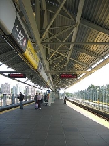
system to Lougheed Town Centre Station
Lougheed Town Centre Station
Lougheed Town Centre Station is a station on the Millennium Line, part of the SkyTrain rapid transit system in Metro Vancouver, British Columbia.-Location:...
on the SkyTrain
SkyTrain (Vancouver)
SkyTrain is a light rapid transit system in Metro Vancouver, British Columbia, Canada. SkyTrain has of track and uses fully automated trains on grade-separated tracks, running mostly on elevated guideways, which helps SkyTrain to hold consistently high on-time reliability...
system. It is operated by Coast Mountain Bus Company
Coast Mountain Bus Company
Coast Mountain Bus Company is the contract operator for bus transit services in Metro Vancouver and is a wholly owned subsidiary of the South Coast British Columbia Transportation Authority known locally as TransLink, the entity responsible for transit...
and funded by TransLink. Going west, the route goes along Clarke Rd., St. John's St., Ioco Rd, Guildford Way and Pinetree Way, and serves Burnaby, Port Moody, and Coquitlam. The line carries over 6,000 passengers daily (http://www.apta.com/research/info/briefings/documents/mills.pdf, PDF file) and will be replaced by the Evergreen Line in 2014.
Unlike the other B-Line services, this route mainly uses conventional 40-foot buses with no special paint scheme.
Burquitlam Stops
- Lougheed Town Centre StationLougheed Town Centre StationLougheed Town Centre Station is a station on the Millennium Line, part of the SkyTrain rapid transit system in Metro Vancouver, British Columbia.-Location:...
1 - connects to the SkyTrainSkyTrain (Vancouver)SkyTrain is a light rapid transit system in Metro Vancouver, British Columbia, Canada. SkyTrain has of track and uses fully automated trains on grade-separated tracks, running mostly on elevated guideways, which helps SkyTrain to hold consistently high on-time reliability...
system and also serves the Lougheed Town CentreLougheed Town CentreLougheed Town Centre is a shopping mall in Burnaby, British Columbia. It is located in the northeast corner of the city, near the border with Coquitlam....
shopping mall and the standing stonesStanding Stones of LougheedThe Standing Stones of Lougheed are a group of five stones located beside the SkyTrain station at Lougheed Town Centre in Burnaby, which is near the city of Vancouver...
. - Lougheed Mall/Austin1 - an alternate stop for the Lougheed Town Centre mall.
- Cameron1 - serves the Sullivan Heights neighbourhood in Burnaby.
- Foster1 - alternate stop for Sullivan Heights.
- Smith - serves the Plaza Burquitlam shopping area.
- Como Lake - alternate stop for the Plaza Burquitlam.
1: This stop is located on the street separating Burnaby and Coquitlam.
Port Moody Stops
- Glenayre - serves the Glenayre and Seaview neighbourhoods of Port Moody, with connections to a local community shuttle.
- Barnet - serves the East Hill neighbourhood.
- Queens - serves the northwestern part of the Harbour Chines neighbourhood and the Port Moody Station Museum.
- Williams - serves the Port Moody StationPort Moody StationPort Moody Station is a station on the West Coast Express commuter rail line connecting Vancouver to Mission, British Columbia, Canada. The station is located on the south side of the Canadian Pacific Railway tracks in Port Moody, at the north foot of William Street, approximately north of St....
of the West Coast ExpressWest Coast ExpressWest Coast Express is the interregional commuter railway in British Columbia, Canada. Opened in 1995, it links Mission, Maple Ridge, Pitt Meadows, Port Coquitlam, Coquitlam, and Port Moody with Waterfront Station in Downtown Vancouver, where it interchanges with SkyTrain rapid transit, SeaBus and...
and northern Harbour Chines. - Moray - serves the industrial areas in southeast Port Moody.
- Newport - serves the Port Moody City Hall, the local theatre and library, and the Heritage Mountain Shoppers Village strip-mall.
- Ungless - serves Eagle Ridge HospitalEagle Ridge HospitalEagle Ridge Hospital is a medical facility located in Port Moody, British Columbia, on the Port Moody/Coquitlam border. ERH is one of 12 hospitals under the jurisdiction of Fraser Health, which services more than 1.3 million people....
.
Coquitlam Stops
- Falcon - serves the Eagle Ridge neighbourhood around the Coquitlam/Port Moody border.
- Lansdowne - serves the Eagle Ridge and Highland Park neighbourhoods.
- Johnson - serves the Canyon Springs neighbourhood.
- Pinetree - serves the Coquitlam City Hall area and Douglas CollegeDouglas CollegeEstablished in 1970, Douglas College is one of the largest public colleges in British Columbia, Canada serving 14,000 credit students, 9,000 continuing education students and 1,000 international students each year.-Programs:...
's David Lam campus. - Guildford - the same as the Pinetree stop, but going in the opposite direction.
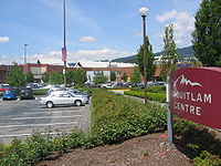
- Lincoln - first stop for the Coquitlam CentreCoquitlam CentreCoquitlam Centre is a shopping mall in Coquitlam, British Columbia, built in 1979 and expanded in 2001. It is located at the southern edge of the Coquitlam Town Centre area, near Coquitlam Central Station and several other smaller shopping centres...
shopping mall; also serves Henderson Place mall and the Westwood neighbourhood. - Coquitlam Central StationCoquitlam Central StationCoquitlam Central Station is a station on the West Coast Express commuter rail line connecting Vancouver to Mission, British Columbia, Canada. The station is located on the north side of the Canadian Pacific Railway tracks in Coquitlam, just west of the Lougheed Highway rail overpass, near the...
- connects to the West Coast Express's Coquitlam Station and the Coquitlam Centre mall; also serves Westwood Mall and Pinetree Village.
See also
- Evergreen Line (Vancouver)
- 99 B-Line99 B-LineThe 99 B-Line is a bus rapid transit line in Metro Vancouver, British Columbia, Canada. It travels along Broadway, a major east-west thoroughfare, and connects the University of British Columbia to Commercial–Broadway Station on the SkyTrain system...
- 98 B-Line98 B-LineThe 98 B-Line was a bus rapid transit line in Metro Vancouver, British Columbia, Canada. It connected Richmond, British Columbia to Downtown Vancouver, with a connection to Vancouver International Airport. It travelled mainly along Granville Street in Vancouver and No. 3 Road in Richmond. It was...
- List of bus routes in Metro Vancouver