
4th Ward of New Orleans
Encyclopedia
The 4th Ward or Fourth Ward is a division of the city of New Orleans
, Louisiana
, United States
, one of the 17 Wards of New Orleans
.
to Lake Pontchartrain
. From the River to Metairie Ridge the upper boundrary is Canal Street, New Orleans
, across which is the 3rd Ward
, and the lower boundary is St. Louis Street, across which is the 5th Ward
. This portion was the original 4th Ward as defined in 1852. In 1880 additional ground (still mostly undeveloped swamp at the time) was added to the Ward from City Park Avenue on Metairie Ridge back to the lake. The upper boundary was the New Basin Canal
, now Pontchartrain Boulevard, across which is the 17th Ward
. The lower boundary is the Orleans Canal
, across which is more of the 5th Ward.
, and the old Bienville Street Wharf, formerly a commercial wharf and now a dock for pleasure cruises of tourist steamboat
s. The Aquarium of the Americas
is near the foot of Canal Street. The next blocks back include such notable businesses as the New Orleans House of Blues
and the Canal Place skyscraper shopping mall/hotel/theater complex. Across Decatur Street, the Ward includes a 4 by 6 block section of the old French Quarter
, including the old U.S. Customs House and some of the most popular businesses on Royal Street and Bourbon Street, some of the blocks most frequented by out-of-town visitors to the city. Across Rampart, near where one of the city's main railroad stations was in the 19th and early 20th century, is the Saenger Theater, a splendid 1920s Movie & Vaudeville Palace which touring Broadway shows and other national acts appear at in the 21st century. In the late 19th and early 20th century Storyville
, is the famous red light district
. In the 1940s most of it was torn down to build the Iberville Projects
. Continuing back, Mercy Hospital is near the headwaters of Bayou St. John
. The Ward includes a narrow strip of Mid City New Orleans, including some of the neighborhood's best known restaurants. Beyond City Park Avenue (formerly Bayou Metairie Road) the Ward widens out from I-10
to City Park, including Delgado Community College
and Greenwood Cemetery
, and the Navarre neighborhood
, including the studios of PBS
television station
WYES-12
. Farther back is the prosperous Lakeview neighborhood
with the commercial strip of Harrison Avenue, and across Robert E. Lee Boulevard the Lakeshore neighborhood, and at the northern end is Lakeshore Park along the lakefront.
Hurricane Katrina
hit most of the Ward hard (see: Effect of Hurricane Katrina on New Orleans
). Lakeview is only some dozen blocks from the notorious breach in the 17th Street Canal
. Narrow strips of land at the two ends of the Ward, in the French Quarter by the Riverfront and on some of the higher ground of the Lakeshore, were above the flood waters. Some of the narrow strip of Metairie Ridge took on only minimal water. Most of the rest of the ward flooded significantly, often severely.
New Orleans, Louisiana
New Orleans is a major United States port and the largest city and metropolitan area in the state of Louisiana. The New Orleans metropolitan area has a population of 1,235,650 as of 2009, the 46th largest in the USA. The New Orleans – Metairie – Bogalusa combined statistical area has a population...
, Louisiana
Louisiana
Louisiana is a state located in the southern region of the United States of America. Its capital is Baton Rouge and largest city is New Orleans. Louisiana is the only state in the U.S. with political subdivisions termed parishes, which are local governments equivalent to counties...
, United States
United States
The United States of America is a federal constitutional republic comprising fifty states and a federal district...
, one of the 17 Wards of New Orleans
Wards of New Orleans
The city of New Orleans, Louisiana is divided into 17 wards. Politically, the wards are used in voting in elections, subdivided into precincts. Under various previous city charters of the 19th century, aldermen and later city council members were elected by ward. The city has not had officials...
.
Boundaries
The 4th Ward stretches through the city from the Mississippi RiverMississippi River
The Mississippi River is the largest river system in North America. Flowing entirely in the United States, this river rises in western Minnesota and meanders slowly southwards for to the Mississippi River Delta at the Gulf of Mexico. With its many tributaries, the Mississippi's watershed drains...
to Lake Pontchartrain
Lake Pontchartrain
Lake Pontchartrain is a brackish estuary located in southeastern Louisiana. It is the second-largest inland saltwater body of water in the United States, after the Great Salt Lake in Utah, and the largest lake in Louisiana. As an estuary, Pontchartrain is not a true lake.It covers an area of with...
. From the River to Metairie Ridge the upper boundrary is Canal Street, New Orleans
Canal Street, New Orleans
Canal Street is a major thoroughfare in the city of New Orleans. Forming the upriver boundary of the city's oldest neighborhood, the French Quarter , it acted as the dividing line between the older French/Spanish Colonial-era city and the newer American Sector, today's Central Business District.The...
, across which is the 3rd Ward
3rd Ward of New Orleans
The 3rd Ward or Third Ward is one of the 17 Wards of New Orleans, a division of the city of New Orleans, Louisiana.-Boundaries:The Ward touches the Mississippi River as its front. The down-river boundary is Canal Street, below which is the city's 4th Ward. The upper boundary is Julia Street,...
, and the lower boundary is St. Louis Street, across which is the 5th Ward
5th Ward of New Orleans
The 5th Ward or Fifth Ward is a division of the city of New Orleans, Louisiana, one of the 17 Wards of New Orleans.-Boundaries:The roughly "L" shaped ward stretches through the city from the Mississippi River to Lake Pontchartrain. The lower boundary is St. Philip Street, across which is the 6th...
. This portion was the original 4th Ward as defined in 1852. In 1880 additional ground (still mostly undeveloped swamp at the time) was added to the Ward from City Park Avenue on Metairie Ridge back to the lake. The upper boundary was the New Basin Canal
New Basin Canal
The New Basin Canal, also known as the New Orleans Canal and the New Canal, was a shipping canal in New Orleans, Louisiana from the 1830s through the 1940s....
, now Pontchartrain Boulevard, across which is the 17th Ward
17th Ward of New Orleans
The 17th Ward is one of the seventeen Wards of New Orleans, a section of the city of New Orleans, Louisiana. New Orleans Districts and Wards. The 17th Ward, along with the 16th, was formed when the City of New Orleans annexed City of Carrollton in 1870....
. The lower boundary is the Orleans Canal
Orleans Canal
The Orleans Canal is a drainage canal in New Orleans, Louisiana. The current version of the canal is about 2 km long, running along the up-river side of City Park, through the Lakeview and Lakeshore neighborhood, and into Lake Pontchartrain...
, across which is more of the 5th Ward.
Neighborhoods and Landmarks
Going roughly from the River to the Lake, the Ward has a portion of the riverfront Woldenberg ParkWoldenberg Park
Woldenberg Park is a park in New Orleans, Louisiana. It was created in the late 1980s/early 1990s on land that had been old wharves and warehouses along the Mississippi River front in the upper French Quarter. It is named after philanthropist Malcolm Woldenberg who helped fund the building of...
, and the old Bienville Street Wharf, formerly a commercial wharf and now a dock for pleasure cruises of tourist steamboat
Steamboat
A steamboat or steamship, sometimes called a steamer, is a ship in which the primary method of propulsion is steam power, typically driving propellers or paddlewheels...
s. The Aquarium of the Americas
Aquarium of the Americas
The Audubon Aquarium of the Americas is a renowned aquarium in New Orleans, Louisiana, USA.Recognized as one of the leading aquariums in the United States, it is run by the Audubon Institute, which also supervises the Audubon Zoo and Audubon Park...
is near the foot of Canal Street. The next blocks back include such notable businesses as the New Orleans House of Blues
House of Blues
House of Blues is a chain of 13 live music concert halls and restaurants in major markets throughout the United States. House of Blues first location was in Cambridge's Harvard Square. It was opened in 1992 by Isaac Tigrett, co-founder of Hard Rock Cafe, and Dan Aykroyd, star of The Blues Brothers...
and the Canal Place skyscraper shopping mall/hotel/theater complex. Across Decatur Street, the Ward includes a 4 by 6 block section of the old French Quarter
French Quarter
The French Quarter, also known as Vieux Carré, is the oldest neighborhood in the city of New Orleans. When New Orleans was founded in 1718 by Jean-Baptiste Le Moyne de Bienville, the city was originally centered on the French Quarter, or the Vieux Carré as it was known then...
, including the old U.S. Customs House and some of the most popular businesses on Royal Street and Bourbon Street, some of the blocks most frequented by out-of-town visitors to the city. Across Rampart, near where one of the city's main railroad stations was in the 19th and early 20th century, is the Saenger Theater, a splendid 1920s Movie & Vaudeville Palace which touring Broadway shows and other national acts appear at in the 21st century. In the late 19th and early 20th century Storyville
Storyville
Storyville was the red-light district of New Orleans, Louisiana, from 1897 through 1917. Locals usually simply referred to the area as The District.-History:...
, is the famous red light district
Red Light District
Red Light District may refer to:* Red-light district - a neighborhood where prostitution is common* The Red Light District - the title of the 2004 album by rapper Ludacris* Red Light District Video - a pornography studio based in Los Angeles, California...
. In the 1940s most of it was torn down to build the Iberville Projects
Iberville Projects
Iberville Projects is a neighborhood of the city of New Orleans and one of the Housing Projects of New Orleans. A subdistrict of the Mid-City District Area, its boundaries as defined by the City Planning Commission are: St. Louis Street to the north, Basin Street to the east, Iberville Street to...
. Continuing back, Mercy Hospital is near the headwaters of Bayou St. John
Bayou St. John
Bayou St. John is a bayou within the city of New Orleans, Louisiana.The Bayou as a natural feature drained the swampy land of a good portion of what was to become New Orleans into Lake Pontchartrain...
. The Ward includes a narrow strip of Mid City New Orleans, including some of the neighborhood's best known restaurants. Beyond City Park Avenue (formerly Bayou Metairie Road) the Ward widens out from I-10
Interstate 10 in Louisiana
Interstate 10, a major transcontinental Interstate Highway in the Southern U.S., runs across the southern part of the U.S. state of Louisiana. It passes through Lake Charles, Lafayette and Baton Rouge before dipping south of Lake Pontchartrain to serve the New Orleans area and then passing through...
to City Park, including Delgado Community College
Delgado Community College
Delgado Community College ' is a Louisiana public community college with campuses throughout the New Orleans metropolitan area, the East and West Banks of New Orleans, the East Bank of Jefferson Parish and on the North Shore of Lake Pontchartrain in Covington and Slidell in St. Tammany Parish...
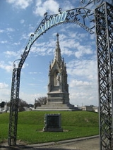
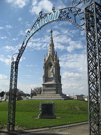
and Greenwood Cemetery
Greenwood Cemetery, New Orleans
Greenwood Cemetery is a cemetery in New Orleans, Louisiana.The cemetery was opened in 1852, and is located on City Park Avenue in the Navarre neighborhood.The cemetery has a number of impressive monuments and sculptures...
, and the Navarre neighborhood
Navarre, New Orleans
Navarre is a neighborhood of the city of New Orleans. A subdistrict of the Lakeview District Area, its boundaries as defined by the City Planning Commission are: I-610, Canal Boulevard and Florida Boulevard to the north, Orleans Avenue to the east, City Park Avenue to the south and the...
, including the studios of PBS
Public Broadcasting Service
The Public Broadcasting Service is an American non-profit public broadcasting television network with 354 member TV stations in the United States which hold collective ownership. Its headquarters is in Arlington, Virginia....
television station
Television station
A television station is a business, organisation or other such as an amateur television operator that transmits content over terrestrial television. A television transmission can be by analog television signals or, more recently, by digital television. Broadcast television systems standards are...
WYES-12
WYES-TV
WYES-TV is the primary Public Broadcasting Service member public television station in New Orleans, Louisiana, owned by the Greater New Orleans Educational Television Foundation. It broadcasts on virtual channel 12.-History:...
. Farther back is the prosperous Lakeview neighborhood
Lakeview, New Orleans
Lakeview is a neighborhood of the city of New Orleans. A subdistrict of the Lakeview District Area, its boundaries as defined by the City Planning Commission are: Robert E. Lee Boulevard to the north, Orleans Avenue to the east, Florida Boulevard, Canal Boulevard and I-610 to the south and...
with the commercial strip of Harrison Avenue, and across Robert E. Lee Boulevard the Lakeshore neighborhood, and at the northern end is Lakeshore Park along the lakefront.
Hurricane Katrina
Hurricane Katrina
Hurricane Katrina of the 2005 Atlantic hurricane season was a powerful Atlantic hurricane. It is the costliest natural disaster, as well as one of the five deadliest hurricanes, in the history of the United States. Among recorded Atlantic hurricanes, it was the sixth strongest overall...
hit most of the Ward hard (see: Effect of Hurricane Katrina on New Orleans
Effect of Hurricane Katrina on New Orleans
The effects of Hurricane Katrina in New Orleans have been long-lasting. As the center of Katrina passed South-east of New Orleans on August 29, 2005, winds downtown were in the Category 3 range with frequent intense gusts and tidal surge. Hurricane force winds were experienced throughout the...
). Lakeview is only some dozen blocks from the notorious breach in the 17th Street Canal
17th Street Canal
The 17th Street Canal is a drainage canal in Greater New Orleans, Louisiana, that flows into Lake Pontchartrain. The canal forms a significant portion of the boundary between the city of New Orleans and Metairie, Louisiana...
. Narrow strips of land at the two ends of the Ward, in the French Quarter by the Riverfront and on some of the higher ground of the Lakeshore, were above the flood waters. Some of the narrow strip of Metairie Ridge took on only minimal water. Most of the rest of the ward flooded significantly, often severely.