

2008 Bihar flood
Encyclopedia
The 2008 Bihar flood was one of the most disastrous floods in the history of Bihar
, an impoverished and densely populated state in India
. A breach in the Kosi embankment
near the Indo-Nepal border (at Kusha
in Nepal
) occurred on 18 August 2008. The river changed course and inundated areas which hadn't experienced floods in many decades. The flood affected over 2.3 million people in the northern part of Bihar.
rains and poor maintenance caused a breach in the Kosi embankment
. Water passed through the breach at an estimated 129,800 m³/s, inundating hundreds of villages in northern Bihar. The flood submerged most of the Kosi alluvial fan
area, which is very fertile, with a dense agrarian population.
and eastern Nepal drains some 60,000 km² of mountainous terrain, a region that tectonic forces are elevating by about 1 cm a year. If erosion keeps pace with geologic uplift, an estimated 600 million cubic meters of sediment is potentially carried downstream in an average year. However, empirical measurements of the river's sediment load have yielded estimates of 100 million cubic meters annually, indicating that the area is rising.
River gradient ranges from more than 10 meters/km for major upper tributaries in the mountains to as little as 6 cm/km as the lower Kosi nears the Ganges. As the gradient decreases on the plains, current slows and turbulence that holds sediments in suspension diminishes. Sediments settle out and are deposited on the riverbed. This process eventually raises a channel above the surrounding terrain. The river breaks out, seeking lower terrain, which it again proceeds to elevate by deposition. This creates a cone-shaped alluvial fan. The Kosi alluvial fan is one of the largest in the world, covering some 15,000 km² and extending 180 km from the outermost foothills of the Himalayas to the Ganges river valley.
Flood waters naturally spread out over the surface of this cone. Flows over 25,000 m³/s have been measured where the Kosi exits the Himalayan foothills, enough to create a flow of water 30 km wide. At this rate, in one week enough water would accumulate to cover the entire megafan to a depth of 1.5 meters.
Preventative flood control measures include upstream reservoirs that can also serve irrigation needs and produce hydroelectric power. However, in Nepal these are mostly in the planning stages. The flood control measures mainly consist of downstream embankments meant to confine the river to a fixed channel. In theory, the faster flow along this channel would carry high flows away and keep sediments in suspension.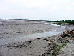 On 18 August 2008 one of the man-made embankments failed. The river reverted from the prescribed western channel to an old channel near the centre of its alluvial fan. The river spread out widely and inundated towns, villages, and cultivated fields on the densely populated alluvial fan. Recurrent flooding on the lower Kosi contributes largely to India's history of suffering more flood deaths than any other country except Bangladesh
, and has earned the Kosi the epithet "The Sorrow of Bihar".
, Araria
, Saharsa
, Madhepura
, Bhagalpur
, West Champaran and Purnea. The southeast Tarai ecoregion
of Nepal was also affected.
The flood killed 250 people and forced nearly 3 million people from their homes in Bihar. More than 300,000 houses were destroyed and at least 340,000 hectares (840,000 acres) of crops were damaged. Villagers in Bihar ate raw rice and flour mixed with polluted water. Hunger and disease were widespread. The Supaul district was the worst-hit; surging waters swamped 1,000 square kilometres (247,000 acres) of farmlands, destroying crops.
, Chief Minister of Bihar, met Indian Prime Minister
Manmohan Singh
to seek his help in dealing with the "catastrophe".
The Prime Minister declared a “national calamity” on 28 August and earmarked US$230 million in aid for the region. Rescue operations were carried out by the Indian Army, National Disaster Response Force (NDRF)
and non-government organizations. Indian Air Force
helicopters dropped relief supplies in the worst-hit districts. Mumbai Fire Brigade
sent a 22-member disaster management team to help in relief work.
Chief Minister Kumar requested a rehabilitation package of Rs
14,500 crore
from the central government for the flood ravaged Kosi region.
The Bihar government returned funds from Gujarat for relief work because of purported differences with the Gujarat Chief Minister, Narendra Modi
.
On 1 September, describing the floods as a “disaster,” the Dalai Lama gave 10 lakh
rupees to the Bihar government for relief work.
The Government of Bihar initiated Kosi Reconstruction and Rehabilitation Programme covering 30,000 affected families in Saharsa, Supaul and Madhepura district based on a pilot project implemented by ODR Collaborative, a network of organizations, supporting the Government and an owner driven reconstruction policy was formulated to support each family with Rs. 55,000 to construct their own house. After signing an agreement with the World Bank in January 2011, this programme has been upscaled to cover 100,000 families for reconstruction of hazard safe houses. The cost per house will be Rs. 55,000 ($1200) with an additional cost of Rs. 2,300 ($50) for a toilet and Rs. 5,000 ($110) for solar powered lighting. In cases where beneficiaries do not own land, the Government of Bihar will provide additional assistance of Rs. 5000 ($110) for the people to buy the land. Towards this project, the World Bank is contributing $220 million. The Government of Bihar has also partnered with ODR Collaborative and UNDP to continue the social and technical facilitation and capacity building for this 'owner driven reconstruction' programme. Technical guidelines have been brought out to enable owners to build houses with various local materials including bamboo.
Bihar
Bihar is a state in eastern India. It is the 12th largest state in terms of geographical size at and 3rd largest by population. Almost 58% of Biharis are below the age of 25, which is the highest proportion in India....
, an impoverished and densely populated state in India
India
India , officially the Republic of India , is a country in South Asia. It is the seventh-largest country by geographical area, the second-most populous country with over 1.2 billion people, and the most populous democracy in the world...
. A breach in the Kosi embankment
Kosi embankment
The Kosi embankments were built in late 1950s to retain the Kosi River which is a transboundary river between Nepal and India and is one of the largest tributaries of the Ganges....
near the Indo-Nepal border (at Kusha
Kusha
Kusha may refer to:* Kusha , one of six schools of Japanese Buddhism in the Nara period* Kusha , in Hindu mythology, was one of the twin sons of Lord Rama and Sita* Kusha, tall tufted perennial grass. See also: Poa cynosuroides...
in Nepal
Nepal
Nepal , officially the Federal Democratic Republic of Nepal, is a landlocked sovereign state located in South Asia. It is located in the Himalayas and bordered to the north by the People's Republic of China, and to the south, east, and west by the Republic of India...
) occurred on 18 August 2008. The river changed course and inundated areas which hadn't experienced floods in many decades. The flood affected over 2.3 million people in the northern part of Bihar.
Incident
On 18 August 2008, heavy monsoonMonsoon
Monsoon is traditionally defined as a seasonal reversing wind accompanied by corresponding changes in precipitation, but is now used to describe seasonal changes in atmospheric circulation and precipitation associated with the asymmetric heating of land and sea...
rains and poor maintenance caused a breach in the Kosi embankment
Embankment
Embankment may refer to:* A levee or dike, an artificial bank raised above the immediately surrounding land to redirect or prevent flooding by a river, lake or sea...
. Water passed through the breach at an estimated 129,800 m³/s, inundating hundreds of villages in northern Bihar. The flood submerged most of the Kosi alluvial fan
Alluvial fan
An alluvial fan is a fan-shaped deposit formed where a fast flowing stream flattens, slows, and spreads typically at the exit of a canyon onto a flatter plain. A convergence of neighboring alluvial fans into a single apron of deposits against a slope is called a bajada, or compound alluvial...
area, which is very fertile, with a dense agrarian population.
Background
The Kosi River's upper basin in southern TibetTibet
Tibet is a plateau region in Asia, north-east of the Himalayas. It is the traditional homeland of the Tibetan people as well as some other ethnic groups such as Monpas, Qiang, and Lhobas, and is now also inhabited by considerable numbers of Han and Hui people...
and eastern Nepal drains some 60,000 km² of mountainous terrain, a region that tectonic forces are elevating by about 1 cm a year. If erosion keeps pace with geologic uplift, an estimated 600 million cubic meters of sediment is potentially carried downstream in an average year. However, empirical measurements of the river's sediment load have yielded estimates of 100 million cubic meters annually, indicating that the area is rising.
River gradient ranges from more than 10 meters/km for major upper tributaries in the mountains to as little as 6 cm/km as the lower Kosi nears the Ganges. As the gradient decreases on the plains, current slows and turbulence that holds sediments in suspension diminishes. Sediments settle out and are deposited on the riverbed. This process eventually raises a channel above the surrounding terrain. The river breaks out, seeking lower terrain, which it again proceeds to elevate by deposition. This creates a cone-shaped alluvial fan. The Kosi alluvial fan is one of the largest in the world, covering some 15,000 km² and extending 180 km from the outermost foothills of the Himalayas to the Ganges river valley.
Flood waters naturally spread out over the surface of this cone. Flows over 25,000 m³/s have been measured where the Kosi exits the Himalayan foothills, enough to create a flow of water 30 km wide. At this rate, in one week enough water would accumulate to cover the entire megafan to a depth of 1.5 meters.
Preventative flood control measures include upstream reservoirs that can also serve irrigation needs and produce hydroelectric power. However, in Nepal these are mostly in the planning stages. The flood control measures mainly consist of downstream embankments meant to confine the river to a fixed channel. In theory, the faster flow along this channel would carry high flows away and keep sediments in suspension.
Bangladesh
Bangladesh , officially the People's Republic of Bangladesh is a sovereign state located in South Asia. It is bordered by India on all sides except for a small border with Burma to the far southeast and by the Bay of Bengal to the south...
, and has earned the Kosi the epithet "The Sorrow of Bihar".
Affected areas
Flooding occurred throughout the Kosi River valley in northern Bihar, in the districts of SupaulSupaul
Supaul is a town and a municipality that is headquarters of Supaul district in the Indian state of Bihar. Not far from this place is the Indian border connecting Nepal. The Supaul Town is the administrative headquarters of this district....
, Araria
Araria
Araria is a town and a municipality that is headquarters of Araria district in the state of Bihar, India.-Geography:Araria is located at . It has an average elevation of 47 metres . Araria is situated at the northern part of Purnia and Madhepura in Bihar...
, Saharsa
Saharsa
Saharsa is a city and a municipality in the Saharsa district in the Indian state of Bihar in north India, east of the Kosi River. It is the administrative headquarters of the Saharsa District, and is in the Kosi Division. Sahrasa is also the name of the Parliamentary constituency, which contains...
, Madhepura
Madhepura
Madhepura is a city and a municipality in Madhepura district in the Indian state of Bihar. Madhepura as it stands now was carved out of Saharsa district and got the status of revenue district on 9 May 1981. Prior to that, Madhepura was a sub-division under Bhagalpur district with effect from 3...
, Bhagalpur
Bhagalpur
Bhagdattpuram was one of the most influential towns in "Aryavarta" . It is supposed to have been concurrent to Patliputra or Patna. Bhagdattpuram finds its mention in the Vedas and Ramayana as well. It is supposed to be the kingdom of Daanvir Karna, the son of Kunti and the Sun God...
, West Champaran and Purnea. The southeast Tarai ecoregion
Ecoregion
An ecoregion , sometimes called a bioregion, is an ecologically and geographically defined area that is smaller than an ecozone and larger than an ecosystem. Ecoregions cover relatively large areas of land or water, and contain characteristic, geographically distinct assemblages of natural...
of Nepal was also affected.
The flood killed 250 people and forced nearly 3 million people from their homes in Bihar. More than 300,000 houses were destroyed and at least 340,000 hectares (840,000 acres) of crops were damaged. Villagers in Bihar ate raw rice and flour mixed with polluted water. Hunger and disease were widespread. The Supaul district was the worst-hit; surging waters swamped 1,000 square kilometres (247,000 acres) of farmlands, destroying crops.
Relief and Rehabilitation Work
In response to the disaster, widely reported as the region's worst flood in 50 years, Nitish KumarNitish Kumar
Nitish Kumār is an Indian politician currently serving as Chief Minister of Bihar, an eastern state of India. He leads the Janata Dal party...
, Chief Minister of Bihar, met Indian Prime Minister
Prime Minister of India
The Prime Minister of India , as addressed to in the Constitution of India — Prime Minister for the Union, is the chief of government, head of the Council of Ministers and the leader of the majority party in parliament...
Manmohan Singh
Manmohan Singh
Manmohan Singh is the 13th and current Prime Minister of India. He is the only Prime Minister since Jawaharlal Nehru to return to power after completing a full five-year term. A Sikh, he is the first non-Hindu to occupy the office. Singh is also the 7th Prime Minister belonging to the Indian...
to seek his help in dealing with the "catastrophe".
The Prime Minister declared a “national calamity” on 28 August and earmarked US$230 million in aid for the region. Rescue operations were carried out by the Indian Army, National Disaster Response Force (NDRF)
National Disaster Response Force (NDRF)
The DM Act, 2005 has made the statutory provisions for the constitution of the National Disaster Response Force for the purpose of specialized response to natural and man-made disasters...
and non-government organizations. Indian Air Force
Indian Air Force
The Indian Air Force is the air arm of the Indian armed forces. Its primary responsibility is to secure Indian airspace and to conduct aerial warfare during a conflict...
helicopters dropped relief supplies in the worst-hit districts. Mumbai Fire Brigade
Mumbai Fire Brigade
The Mumbai Fire Brigade is responsible for the provision of fire protection in the City of Greater Mumbai as well as responding to building collapses, drowning cases, gas leakage, oil spillage, road and rail accidents, bird and animal rescues, fallen trees and taking appropriate action during...
sent a 22-member disaster management team to help in relief work.
Chief Minister Kumar requested a rehabilitation package of Rs
Rupee
The rupee is the common name for the monetary unit of account in India, Sri Lanka, Nepal, Pakistan, Mauritius, Seychelles, Maldives, and formerly in Burma, and Afghanistan. Historically, the first currency called "rupee" was introduced in the 16th century...
14,500 crore
Crore
A crore is a unit in the Indian number system equal to ten million , or 100 lakhs. It is widely used in India, Bangladesh, Nepal, and Pakistan....
from the central government for the flood ravaged Kosi region.
The Bihar government returned funds from Gujarat for relief work because of purported differences with the Gujarat Chief Minister, Narendra Modi
Narendra Modi
Narendra Damodardas Modi is the current Chief Minister of the Indian state of Gujarat.He was born in a middle class family in Vadnagar; and is a member of Rashtriya Swayamsevak Sangh since childhood, as also an active politician since early in life. He holds a masters degree in political...
.
On 1 September, describing the floods as a “disaster,” the Dalai Lama gave 10 lakh
Lakh
A lakh is a unit in the Indian numbering system equal to one hundred thousand . It is widely used both in official and other contexts in Pakistan, Bangladesh, India, Maldives, Nepal, Sri Lanka, Myanmar and is often used in Indian English.-Usage:...
rupees to the Bihar government for relief work.
The Government of Bihar initiated Kosi Reconstruction and Rehabilitation Programme covering 30,000 affected families in Saharsa, Supaul and Madhepura district based on a pilot project implemented by ODR Collaborative, a network of organizations, supporting the Government and an owner driven reconstruction policy was formulated to support each family with Rs. 55,000 to construct their own house. After signing an agreement with the World Bank in January 2011, this programme has been upscaled to cover 100,000 families for reconstruction of hazard safe houses. The cost per house will be Rs. 55,000 ($1200) with an additional cost of Rs. 2,300 ($50) for a toilet and Rs. 5,000 ($110) for solar powered lighting. In cases where beneficiaries do not own land, the Government of Bihar will provide additional assistance of Rs. 5000 ($110) for the people to buy the land. Towards this project, the World Bank is contributing $220 million. The Government of Bihar has also partnered with ODR Collaborative and UNDP to continue the social and technical facilitation and capacity building for this 'owner driven reconstruction' programme. Technical guidelines have been brought out to enable owners to build houses with various local materials including bamboo.
Administrative lapse
Fax messages sent by engineers at the Kosi dam warning the state government of the impending disaster went unheeded as the official authorized to respond was on leave. Consequently, many residents waiting for evacuation instructions never received warning of the flood. Nitish Mishra, Bihar's disaster management minister, said, "There should definitely be some accountability," and that action would be taken.See also
- CNN-IBN 30 Minutes documentary on Bihar Floods 2008 by Marya Shakil – Part 1 Part 2 Part 3 Part 4
- 2008 Indian floods2008 Indian floodsThe 2008 Indian floods were a series of floods in various states of India during the 2008 monsoon season. The floods mostly affected the western regions of Maharashtra state and Andhra Pradesh as well as northern Bihar...
- Flood in Bihar
- Kosi River#2008 flood in Bihar