
2006 Westchester County tornado
Encyclopedia
The 2006 Westchester County tornado was the strongest and largest tornado
in the history of Westchester County, New York
. It touched down there on July 12, 2006 and traveled 13 miles (20.9 km) into southwestern Connecticut
during a 33-minute span through two states. The tornado touched down at 3:30 p.m. EDT
(19:30 UTC
) on the shore of the Hudson River
before becoming a waterspout
and traveling 3 mi (4.8 km) across the river. Coming ashore, the tornado entered Westchester County
and struck the town of Sleepy Hollow
at F1 intensity. After passing through the town, it intensified into an F2 tornado and grew to almost a quarter of a mile (400 m) in diameter. The tornado continued through the county, damaging numerous structures, until it crossed into Connecticut at 4:01 p.m. EDT (20:01 UTC). Not long after entering the state, it dissipated in the town of Greenwich
at 4:03 p.m. EDT (20:03 UTC). When the tornado entered Westchester County, it was the eighth known tornado to either touch down or enter the county since 1950.
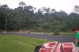
Two barns and a warehouse were destroyed, and a large stained-glass window was shattered. Numerous homes and businesses were damaged and thousands of trees were uprooted. There were no fatalities and only six minor injuries were associated with the storm. The cost of damages was estimated at $12.1 million.
thunderstorm
developed over eastern New Jersey
in association with a surface low-pressure area
in southwestern Ontario
. Daytime heating in the Tri-State Region led to moderate instability, a key factor in the development of showers and thunderstorms
. With conditions favorable for the development of a tornado
, the Storm Prediction Center
issued a tornado watch
at 12:40 p.m. EDT
(16:40 UTC
). A strong thunderstorm developed around 2:00 p.m. EDT (18:00 UTC) which produced a funnel cloud
near Carlstadt
at around 2:45 p.m. EDT (18:45 UTC), although no damage was associated with the funnel. That same storm intensified and developed into a supercell as it crossed into New York
. About 15 minutes later, a tornado warning
was issued for southern Rockland and Westchester
counties which would remain in effect until 4:15 p.m. EDT (21:15 UTC). At around 3:30 p.m. EDT (19:30 UTC), an F1 tornado touched down near Grand View-on-Hudson
along the Hudson River
in Rockland County
. The 100 yard (91 m) wide tornado touched down on a dock before becoming a waterspout
as it took a 3 mi (4.8 km) path across the river. The tornado passed near the Tappan Zee Bridge
before crossing into Westchester County
. Upon entering Westchester, it was the eighth tornado ever recorded in the county.
The tornado hit the town of Sleepy Hollow, New York
, around 3:37 p.m. EDT (19:37 UTC); two minutes later, a 58 mph (93.3 km/h) wind gust was reported along the periphery of the tornado. As the tornado neared New York State Route 9A
, it intensified to F2 status, generating winds up to 157 mph (252.7 km/h), and struck the California Closet Warehouse. At the time, the tornado was estimated to be 300 yd (274 m) wide and was the strongest tornado ever recorded in Westchester County. Shortly after, it weakened back to F1 intensity. Minor damage was reported through the Kensico Reservoir
in Valhalla
as the tornado neared the New York–Connecticut
border. The track length through Westchester County was measured at around 8 mi (12.9 km). After crossing the state border into Fairfield County, Connecticut
, it weakened further before lifting at 4:03 p.m EDT (20:03 UTC) in Greenwich
after traveling 2 mi (3.2 km) in Connecticut. Another brief touchdown may have occurred shortly after near the Merritt Parkway
. Overall, the tornado tracked across a total of 13 mi (20.9 km) through two states over a period over 33 minutes.
, Westchester
, and Fairfield
counties, downing or uprooting thousands of trees and damaging several structures, including significant structural damage to the California Closets
warehouse. Six minor injuries were also reported. In all, the tornado inflicted $12.1 million in damage.
Minor damage was reported in Rockland County. One dock and one boat were damaged by the tornado. After crossing the Hudson River
, the tornado entered Westchester County, where the worst of the damage took place. It struck the town of Sleepy Hollow
, damaging roofs and tearing the siding off numerous homes and businesses. A 10 foot (3 m) tall stained-glass window in the St. Teresa of Avila Church was shattered. Afterwards, the town of Pocantico Hills
was struck as the tornado intensified to F2 intensity. Several trees were uprooted and two barns were destroyed. The California Closet Warehouse suffered severe structural damage; two concrete walls were destroyed. An interior staircase, which employees used as a shelter, collapsed causing four injuries. Concrete blocks from the building were blown about, some of which struck cars in a nearby parking lot. A nearby Comfort Inn had part of its roof torn off. After a tornado warning
was issued, a school near the warehouse was evacuated.
As the tornado crossed New York State Route 9A
, it picked up a state trooper car and flipped it several times before it fell to the ground; the officer inside suffered only minor injuries. Moving towards the east-northeast, the tornado struck the towns of Mount Pleasant
and Hawthorne
, damaging numerous trees and causing minor structural damage. Damage along the Saw Mill River Parkway
prompted officials to shut down a section of the highway near Mount Pleasant. Trees fell on streets and railroad tracks, halting Metro-North Railroad
service and creating major traffic delays. After passing by the Kensico Reservoir
in Valhalla
, the tornado crossed into Connecticut
, where it knocked down numerous power lines, cutting power to about 10,000 residences in the county. In all, six people sustained minor injuries and damages amounted to $10.1 million.
The weakening tornado ended its duration in Fairfield County, Connecticut, in the town of Greenwich
. Thousands of trees were either uprooted or snapped along the tornado's 2 mi (3.2 km) path through the state. Minor damage was inflicted upon several structures. The tornado left 1,700 residences in Greenwich without power and blocked six roads. Most of the damage was concentrated to the northwestern corner of the town. Damages in the state totaled to $2 million.
(conEdison) crews were sent out to repair downed power lines and clear roads. By the next night, power was restored to all but 600 of the previous 10,000 residences without power in Westchester
. Westchester County opened its Emergency Operations Center after the storm to quickly respond to the event. Two days after the storm, many of the roads had been cleared and power was fully restored. A recreational path in Tarrytown, New York
, was not expected to be open for another two weeks due to numerous fallen trees. Metro-North Railroad
suspended trains on the Upper Harlem line until 5:00 p.m. EDT (21:00 UTC) for the removal of debris on the tracks. During the time the rails were shut down, southbound passengers were transported by bus. All trains were back on schedule by 7:00 p.m. EDT (23:00 UTC).
Tornado
A tornado is a violent, dangerous, rotating column of air that is in contact with both the surface of the earth and a cumulonimbus cloud or, in rare cases, the base of a cumulus cloud. They are often referred to as a twister or a cyclone, although the word cyclone is used in meteorology in a wider...
in the history of Westchester County, New York
Westchester County, New York
Westchester County is a county located in the U.S. state of New York. Westchester covers an area of and has a population of 949,113 according to the 2010 Census, residing in 45 municipalities...
. It touched down there on July 12, 2006 and traveled 13 miles (20.9 km) into southwestern Connecticut
Connecticut
Connecticut is a state in the New England region of the northeastern United States. It is bordered by Rhode Island to the east, Massachusetts to the north, and the state of New York to the west and the south .Connecticut is named for the Connecticut River, the major U.S. river that approximately...
during a 33-minute span through two states. The tornado touched down at 3:30 p.m. EDT
Eastern Time Zone
The Eastern Time Zone of the United States and Canada is a time zone that falls mostly along the east coast of North America. Its UTC time offset is −5 hrs during standard time and −4 hrs during daylight saving time...
(19:30 UTC
Coordinated Universal Time
Coordinated Universal Time is the primary time standard by which the world regulates clocks and time. It is one of several closely related successors to Greenwich Mean Time. Computer servers, online services and other entities that rely on having a universally accepted time use UTC for that purpose...
) on the shore of the Hudson River
Hudson River
The Hudson is a river that flows from north to south through eastern New York. The highest official source is at Lake Tear of the Clouds, on the slopes of Mount Marcy in the Adirondack Mountains. The river itself officially begins in Henderson Lake in Newcomb, New York...
before becoming a waterspout
Waterspout
A waterspout is an intense columnar vortex that occurs over a body of water and is connected to a cumuliform cloud. In the common form, it is a non-supercell tornado over water. While it is often weaker than most of its land counterparts, stronger versions spawned by mesocyclones do occur...
and traveling 3 mi (4.8 km) across the river. Coming ashore, the tornado entered Westchester County
Westchester County, New York
Westchester County is a county located in the U.S. state of New York. Westchester covers an area of and has a population of 949,113 according to the 2010 Census, residing in 45 municipalities...
and struck the town of Sleepy Hollow
Sleepy Hollow, New York
Sleepy Hollow is a village in the town of Mount Pleasant in Westchester County, New York, United States. It is located on the eastern bank of the Hudson River, about north of midtown Manhattan in New York City, and is served by the Philipse Manor stop on the Metro-North Hudson Line.Originally...
at F1 intensity. After passing through the town, it intensified into an F2 tornado and grew to almost a quarter of a mile (400 m) in diameter. The tornado continued through the county, damaging numerous structures, until it crossed into Connecticut at 4:01 p.m. EDT (20:01 UTC). Not long after entering the state, it dissipated in the town of Greenwich
Greenwich, Connecticut
Greenwich is a town in Fairfield County, Connecticut, United States. As of the 2010 census, the town had a total population of 61,171. It is home to many hedge funds and other financial service companies. Greenwich is the southernmost and westernmost municipality in Connecticut and is 38+ minutes ...
at 4:03 p.m. EDT (20:03 UTC). When the tornado entered Westchester County, it was the eighth known tornado to either touch down or enter the county since 1950.
Two barns and a warehouse were destroyed, and a large stained-glass window was shattered. Numerous homes and businesses were damaged and thousands of trees were uprooted. There were no fatalities and only six minor injuries were associated with the storm. The cost of damages was estimated at $12.1 million.
Meteorological synopsis
On July 12 a supercellSupercell
A supercell is a thunderstorm that is characterized by the presence of a mesocyclone: a deep, continuously-rotating updraft. For this reason, these storms are sometimes referred to as rotating thunderstorms...
thunderstorm
Thunderstorm
A thunderstorm, also known as an electrical storm, a lightning storm, thundershower or simply a storm is a form of weather characterized by the presence of lightning and its acoustic effect on the Earth's atmosphere known as thunder. The meteorologically assigned cloud type associated with the...
developed over eastern New Jersey
New Jersey
New Jersey is a state in the Northeastern and Middle Atlantic regions of the United States. , its population was 8,791,894. It is bordered on the north and east by the state of New York, on the southeast and south by the Atlantic Ocean, on the west by Pennsylvania and on the southwest by Delaware...
in association with a surface low-pressure area
Low pressure area
A low-pressure area, or "low", is a region where the atmospheric pressure at sea level is below that of surrounding locations. Low-pressure systems form under areas of wind divergence which occur in upper levels of the troposphere. The formation process of a low-pressure area is known as...
in southwestern Ontario
Ontario
Ontario is a province of Canada, located in east-central Canada. It is Canada's most populous province and second largest in total area. It is home to the nation's most populous city, Toronto, and the nation's capital, Ottawa....
. Daytime heating in the Tri-State Region led to moderate instability, a key factor in the development of showers and thunderstorms
Atmospheric convection
Atmospheric convection is the result of a parcel-environment instability, or temperature difference, layer in the atmosphere. Different lapse rates within dry and moist air lead to instability. Mixing of air during the day which expands the height of the planetary boundary layer leads to...
. With conditions favorable for the development of a tornado
Tornado
A tornado is a violent, dangerous, rotating column of air that is in contact with both the surface of the earth and a cumulonimbus cloud or, in rare cases, the base of a cumulus cloud. They are often referred to as a twister or a cyclone, although the word cyclone is used in meteorology in a wider...
, the Storm Prediction Center
Storm Prediction Center
The Storm Prediction Center , located in Norman, Oklahoma, is tasked with forecasting the risk of severe thunderstorms and tornadoes in the contiguous United States. The agency issues convective outlooks, mesoscale discussions, and watches as a part of this process...
issued a tornado watch
Tornado watch
A tornado watch is issued when conditions are right for a tornado to form. Since any thunderstorm capable of producing a tornado is defined as severe, a tornado watch is also automatically a severe thunderstorm watch...
at 12:40 p.m. EDT
Eastern Time Zone
The Eastern Time Zone of the United States and Canada is a time zone that falls mostly along the east coast of North America. Its UTC time offset is −5 hrs during standard time and −4 hrs during daylight saving time...
(16:40 UTC
Coordinated Universal Time
Coordinated Universal Time is the primary time standard by which the world regulates clocks and time. It is one of several closely related successors to Greenwich Mean Time. Computer servers, online services and other entities that rely on having a universally accepted time use UTC for that purpose...
). A strong thunderstorm developed around 2:00 p.m. EDT (18:00 UTC) which produced a funnel cloud
Funnel cloud
A funnel cloud is a funnel-shaped cloud of condensed water droplets, associated with a rotating column of wind and extending from the base of a cloud but not reaching the ground or a water surface. A funnel cloud is usually visible as a cone-shaped or needle like protuberance from the main cloud...
near Carlstadt
Carlstadt, New Jersey
Carlstadt is a borough in Bergen County, New Jersey, United States. As of the 2010 United States Census, the borough population was 6,127.Carlstadt was originally formed as a village by an Act of the New Jersey Legislature on March 12, 1860, within Lodi Township. It was named after Dr...
at around 2:45 p.m. EDT (18:45 UTC), although no damage was associated with the funnel. That same storm intensified and developed into a supercell as it crossed into New York
New York
New York is a state in the Northeastern region of the United States. It is the nation's third most populous state. New York is bordered by New Jersey and Pennsylvania to the south, and by Connecticut, Massachusetts and Vermont to the east...
. About 15 minutes later, a tornado warning
Tornado warning
A tornado warning is an alert issued by government weather services to warn that severe thunderstorms with tornadoes may be imminent. It can be issued after a tornado or funnel cloud has been spotted by eye, or more commonly if there are radar indications of tornado formation...
was issued for southern Rockland and Westchester
Westchester County, New York
Westchester County is a county located in the U.S. state of New York. Westchester covers an area of and has a population of 949,113 according to the 2010 Census, residing in 45 municipalities...
counties which would remain in effect until 4:15 p.m. EDT (21:15 UTC). At around 3:30 p.m. EDT (19:30 UTC), an F1 tornado touched down near Grand View-on-Hudson
Grand View-on-Hudson, New York
Grand View-on-Hudson is a village in Rockland County, New York, United States located north of Piermont; east of Orangeburg; south of South Nyack and west of the Hudson River. The population, one of the most affluent incorporated communities in the United States, was 284 at the 2000 census. The...
along the Hudson River
Hudson River
The Hudson is a river that flows from north to south through eastern New York. The highest official source is at Lake Tear of the Clouds, on the slopes of Mount Marcy in the Adirondack Mountains. The river itself officially begins in Henderson Lake in Newcomb, New York...
in Rockland County
Rockland County, New York
Rockland County is a suburban county 15 miles to the northwest of Manhattan and part of the New York City Metropolitan Area, in the U.S. state of New York. It is the southernmost county in New York west of the Hudson River, and the smallest county in New York outside of New York City. The...
. The 100 yard (91 m) wide tornado touched down on a dock before becoming a waterspout
Waterspout
A waterspout is an intense columnar vortex that occurs over a body of water and is connected to a cumuliform cloud. In the common form, it is a non-supercell tornado over water. While it is often weaker than most of its land counterparts, stronger versions spawned by mesocyclones do occur...
as it took a 3 mi (4.8 km) path across the river. The tornado passed near the Tappan Zee Bridge
Tappan Zee Bridge
The Governor Malcolm Wilson Tappan Zee Bridge, usually referred to as Tappan Zee Bridge, is a cantilever bridge in New York over the Hudson River at one of its widest points; the Tappan Zee is named for an American Indian tribe from the area called "Tappan"; and zee being the Dutch word for "sea"....
before crossing into Westchester County
Westchester County, New York
Westchester County is a county located in the U.S. state of New York. Westchester covers an area of and has a population of 949,113 according to the 2010 Census, residing in 45 municipalities...
. Upon entering Westchester, it was the eighth tornado ever recorded in the county.
The tornado hit the town of Sleepy Hollow, New York
Sleepy Hollow, New York
Sleepy Hollow is a village in the town of Mount Pleasant in Westchester County, New York, United States. It is located on the eastern bank of the Hudson River, about north of midtown Manhattan in New York City, and is served by the Philipse Manor stop on the Metro-North Hudson Line.Originally...
, around 3:37 p.m. EDT (19:37 UTC); two minutes later, a 58 mph (93.3 km/h) wind gust was reported along the periphery of the tornado. As the tornado neared New York State Route 9A
New York State Route 9A
New York State Route 9A is a state highway in the vicinity of New York City, New York, United States. Its southern terminus is at the northern end of the Brooklyn–Battery Tunnel in New York City, where it intersects with both Interstate 478 and FDR Drive. The northern terminus of...
, it intensified to F2 status, generating winds up to 157 mph (252.7 km/h), and struck the California Closet Warehouse. At the time, the tornado was estimated to be 300 yd (274 m) wide and was the strongest tornado ever recorded in Westchester County. Shortly after, it weakened back to F1 intensity. Minor damage was reported through the Kensico Reservoir
Kensico Reservoir
The Kensico Reservoir is a reservoir, located in the village of Valhalla and in the town of North Castle, that was put into service in 1915. It is about 3 miles north of White Plains, New York, and about 15 miles north of New York City...
in Valhalla
Valhalla, New York
Valhalla is an unincorporated hamlet and census-designated place that is located within the town of Mount Pleasant, New York, in Westchester County. Its population was 3,162 at the 2010 U.S. Census...
as the tornado neared the New York–Connecticut
Connecticut
Connecticut is a state in the New England region of the northeastern United States. It is bordered by Rhode Island to the east, Massachusetts to the north, and the state of New York to the west and the south .Connecticut is named for the Connecticut River, the major U.S. river that approximately...
border. The track length through Westchester County was measured at around 8 mi (12.9 km). After crossing the state border into Fairfield County, Connecticut
Fairfield County, Connecticut
Fairfield County is a county located in the southwestern corner of the U.S. state of Connecticut. The county population is 916,829 according to the 2010 Census. There are currently 1,465 people per square mile in the county. It is the most populous county in the State of Connecticut and contains...
, it weakened further before lifting at 4:03 p.m EDT (20:03 UTC) in Greenwich
Greenwich, Connecticut
Greenwich is a town in Fairfield County, Connecticut, United States. As of the 2010 census, the town had a total population of 61,171. It is home to many hedge funds and other financial service companies. Greenwich is the southernmost and westernmost municipality in Connecticut and is 38+ minutes ...
after traveling 2 mi (3.2 km) in Connecticut. Another brief touchdown may have occurred shortly after near the Merritt Parkway
Merritt Parkway
The Merritt Parkway is a historic limited-access parkway in Fairfield County, Connecticut. The parkway is known for its scenic layout, its uniquely styled signage, and the architecturally elaborate overpasses along the route. It is designated as a National Scenic Byway and is also listed in the...
. Overall, the tornado tracked across a total of 13 mi (20.9 km) through two states over a period over 33 minutes.
Impact
The tornado took a path through RocklandRockland County, New York
Rockland County is a suburban county 15 miles to the northwest of Manhattan and part of the New York City Metropolitan Area, in the U.S. state of New York. It is the southernmost county in New York west of the Hudson River, and the smallest county in New York outside of New York City. The...
, Westchester
Westchester County, New York
Westchester County is a county located in the U.S. state of New York. Westchester covers an area of and has a population of 949,113 according to the 2010 Census, residing in 45 municipalities...
, and Fairfield
Fairfield County, Connecticut
Fairfield County is a county located in the southwestern corner of the U.S. state of Connecticut. The county population is 916,829 according to the 2010 Census. There are currently 1,465 people per square mile in the county. It is the most populous county in the State of Connecticut and contains...
counties, downing or uprooting thousands of trees and damaging several structures, including significant structural damage to the California Closets
California Closets
California Closets is a closet company headquartered in Berkeley, California. Its main products are centered around custom made storage solutions for any area within the home....
warehouse. Six minor injuries were also reported. In all, the tornado inflicted $12.1 million in damage.
Minor damage was reported in Rockland County. One dock and one boat were damaged by the tornado. After crossing the Hudson River
Hudson River
The Hudson is a river that flows from north to south through eastern New York. The highest official source is at Lake Tear of the Clouds, on the slopes of Mount Marcy in the Adirondack Mountains. The river itself officially begins in Henderson Lake in Newcomb, New York...
, the tornado entered Westchester County, where the worst of the damage took place. It struck the town of Sleepy Hollow
Sleepy Hollow, New York
Sleepy Hollow is a village in the town of Mount Pleasant in Westchester County, New York, United States. It is located on the eastern bank of the Hudson River, about north of midtown Manhattan in New York City, and is served by the Philipse Manor stop on the Metro-North Hudson Line.Originally...
, damaging roofs and tearing the siding off numerous homes and businesses. A 10 foot (3 m) tall stained-glass window in the St. Teresa of Avila Church was shattered. Afterwards, the town of Pocantico Hills
Pocantico Hills, New York
Pocantico Hills is a hamlet in the town of Mount Pleasant, New York, northeast of the village of Sleepy Hollow and southwest of the village of Pleasantville. The area was originally settled by native Americans of the Wecquaesgeek tribes; "Pocantico" means "running between two hills," and the name...
was struck as the tornado intensified to F2 intensity. Several trees were uprooted and two barns were destroyed. The California Closet Warehouse suffered severe structural damage; two concrete walls were destroyed. An interior staircase, which employees used as a shelter, collapsed causing four injuries. Concrete blocks from the building were blown about, some of which struck cars in a nearby parking lot. A nearby Comfort Inn had part of its roof torn off. After a tornado warning
Tornado warning
A tornado warning is an alert issued by government weather services to warn that severe thunderstorms with tornadoes may be imminent. It can be issued after a tornado or funnel cloud has been spotted by eye, or more commonly if there are radar indications of tornado formation...
was issued, a school near the warehouse was evacuated.
As the tornado crossed New York State Route 9A
New York State Route 9A
New York State Route 9A is a state highway in the vicinity of New York City, New York, United States. Its southern terminus is at the northern end of the Brooklyn–Battery Tunnel in New York City, where it intersects with both Interstate 478 and FDR Drive. The northern terminus of...
, it picked up a state trooper car and flipped it several times before it fell to the ground; the officer inside suffered only minor injuries. Moving towards the east-northeast, the tornado struck the towns of Mount Pleasant
Mount Pleasant, New York
Mount Pleasant is a town in Westchester County, New York, in the United States. As of the 2010 census, the town population was 43,724.-Geography:...
and Hawthorne
Hawthorne, New York
Hawthorne is an unincorporated hamlet and census-designated place located in the town of Mount Pleasant in Westchester County, New York. The population was 4,586 at the 2010 census.-History:...
, damaging numerous trees and causing minor structural damage. Damage along the Saw Mill River Parkway
Saw Mill River Parkway
The Saw Mill River Parkway is a north–south parkway that extends for through Westchester County, New York, in the United States. It begins at the border between Westchester County and the Bronx, where it continues into New York City as the Henry Hudson Parkway, and heads generally...
prompted officials to shut down a section of the highway near Mount Pleasant. Trees fell on streets and railroad tracks, halting Metro-North Railroad
Metro-North Railroad
The Metro-North Commuter Railroad , trading as MTA Metro-North Railroad, or, more commonly, Metro-North, is a suburban commuter rail service that is run and managed by the Metropolitan Transportation Authority , an authority of New York State. It is the busiest commuter railroad in the United...
service and creating major traffic delays. After passing by the Kensico Reservoir
Kensico Reservoir
The Kensico Reservoir is a reservoir, located in the village of Valhalla and in the town of North Castle, that was put into service in 1915. It is about 3 miles north of White Plains, New York, and about 15 miles north of New York City...
in Valhalla
Valhalla, New York
Valhalla is an unincorporated hamlet and census-designated place that is located within the town of Mount Pleasant, New York, in Westchester County. Its population was 3,162 at the 2010 U.S. Census...
, the tornado crossed into Connecticut
Connecticut
Connecticut is a state in the New England region of the northeastern United States. It is bordered by Rhode Island to the east, Massachusetts to the north, and the state of New York to the west and the south .Connecticut is named for the Connecticut River, the major U.S. river that approximately...
, where it knocked down numerous power lines, cutting power to about 10,000 residences in the county. In all, six people sustained minor injuries and damages amounted to $10.1 million.
The weakening tornado ended its duration in Fairfield County, Connecticut, in the town of Greenwich
Greenwich, Connecticut
Greenwich is a town in Fairfield County, Connecticut, United States. As of the 2010 census, the town had a total population of 61,171. It is home to many hedge funds and other financial service companies. Greenwich is the southernmost and westernmost municipality in Connecticut and is 38+ minutes ...
. Thousands of trees were either uprooted or snapped along the tornado's 2 mi (3.2 km) path through the state. Minor damage was inflicted upon several structures. The tornado left 1,700 residences in Greenwich without power and blocked six roads. Most of the damage was concentrated to the northwestern corner of the town. Damages in the state totaled to $2 million.
Aftermath
In the wake of the tornado, the mayor of Sleepy Hollow declared a village-wide state of emergency. Two hundred emergency personnel responded to the storm. Consolidated EdisonConsolidated Edison
Consolidated Edison, Inc. is one of the largest investor-owned energy companies in the United States, with approximately $14 billion in annual revenues and $36 billion in assets...
(conEdison) crews were sent out to repair downed power lines and clear roads. By the next night, power was restored to all but 600 of the previous 10,000 residences without power in Westchester
Westchester County, New York
Westchester County is a county located in the U.S. state of New York. Westchester covers an area of and has a population of 949,113 according to the 2010 Census, residing in 45 municipalities...
. Westchester County opened its Emergency Operations Center after the storm to quickly respond to the event. Two days after the storm, many of the roads had been cleared and power was fully restored. A recreational path in Tarrytown, New York
Tarrytown, New York
Tarrytown is a village in the town of Greenburgh in Westchester County, New York, United States. It is located on the eastern bank of the Hudson River, about north of midtown Manhattan in New York City, and is served by a stop on the Metro-North Hudson Line...
, was not expected to be open for another two weeks due to numerous fallen trees. Metro-North Railroad
Metro-North Railroad
The Metro-North Commuter Railroad , trading as MTA Metro-North Railroad, or, more commonly, Metro-North, is a suburban commuter rail service that is run and managed by the Metropolitan Transportation Authority , an authority of New York State. It is the busiest commuter railroad in the United...
suspended trains on the Upper Harlem line until 5:00 p.m. EDT (21:00 UTC) for the removal of debris on the tracks. During the time the rails were shut down, southbound passengers were transported by bus. All trains were back on schedule by 7:00 p.m. EDT (23:00 UTC).
See also
- 1900 Westchester County tornado1900 Westchester County tornadoThe 1900 Westchester County tornado was an intense, but short-lived tornado that caused significant damage near the city of New Rochelle.-Synopsis:...
- 1904 Chappaqua tornado1904 Chappaqua tornadoThe 1904 Chappaqua tornado was an intense tornado that struck northern Westchester County, New York during the afternoon of July 16, 1904. As of 2009, this tornado ranks as the strongest tornado to touch down in the county, ranking as F3 on the modern-day Fujita Scale. The tornado formed around...
- List of Connecticut tornadoes
- List of North American tornadoes and tornado outbreaks
- Tornadoes of 2006
External links
- http://wcbstv.com/video/?id=89570@wcbs.dayport.com Doppler Radar image of the tornadic supercell nearing Tarrytown
- http://www.youtube.com/watch?v=_fLZLrZAB0M Video of the tornado damage in Westchester
- http://wcbstv.com/topstories/Tornado.Tornado.Warning.2.236314.html WCBS article and video of damage/press reports of the tornado
- http://www.brianduddy.com/g/071206 On scene photos from the Tornado aftermath