
2005 Kashmir earthquake
Encyclopedia
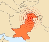
The 2005 Kashmir earthquake was a major earthquake
centered
in Pakistan-administered Kashmir
known as Azad Kashmir
, near the city of Muzaffarabad
, affecting Gilgit-Baltistan and Khyber Pakhtunkhwa province of Pakistan
. It occurred at 08:52:37 Pakistan Standard Time
(03:52:37 GMT) on 8 October 2005. It registered a moment magnitude
of 7.6 making it similar in size to the 1906 San Francisco earthquake
, the 1935 Quetta earthquake, the 2001 Gujarat earthquake
, and the 2009 Sumatra earthquakes
. As of 8 November, the government of Pakistan
's official death toll was 75,000. The earthquake also affected countries in the surrounding region where tremors were felt in Tajikistan
and western China, while officials say nearly 1,400 people also died in Indian-administered Kashmir and four people in Afghanistan
. The severity of the damage caused by the earthquake is attributed to severe upthrust, coupled with poor construction.
Well over US$
5.4 billion (400 billion Pakistani rupee
s) in aid arrived from all around the world. US Marine and Army helicopters stationed in neighbouring Afghanistan
quickly flew aid into the devastated region. Five crossing points were opened on the Line of Control
(LoC) between India and Pakistan to facilitate the flow of humanitarian and medical aid to the affected region, and international aid teams from around the world came to the region to assist in relief.
 Pakistan-administered Kashmir
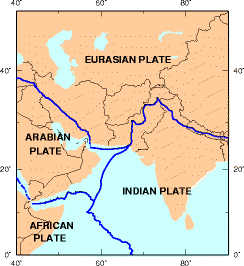
lies in the area of collision of the Eurasian
and Indian tectonic plates
. The geological activity born out of this collision, also responsible for the birth of the Himalayan mountain range, is the cause of unstable seismicity in the region. The Pakistan Meteorological Department
estimated the 5.2 magnitude on the richter scale. The United States Geological Survey
(USGS) measured its magnitude as a minimum of 7.6 on the moment magnitude scale
, with its epicentre at 34°29′35"N 73°37′44"E, about 19 km (11.8 mi) northeast of Muzaffarabad
, Pakistan-administered Kashmir
, and 100 km (62.1 mi) north-northeast of the national capital Islamabad
. The earthquake is classified as "major" by the USGS. The hypocenter
was located at a depth of 26 km (16.2 mi) below the surface. The Japan Meteorological Agency
estimated its moment magnitude at 7.8. By comparison, the 2004 Indian Ocean earthquake
had a magnitude of 9.15. The worst-hit areas were Pakistan-administered Kashmir
, Khyber-Pakhtunkhwa,and western parts of the Kashmir valley in Indian-administered Kashmir. Also affected were some parts of the Pakistani province of Punjab, the capital city of Islamabad
, and the city of Karachi
which experienced a minor aftershock
of magnitude 4.6. There were many secondary earthquakes in the region, mainly to the northwest of the original epicentre. A total of 147 aftershocks were registered in the first day after the initial quake, of which one had a magnitude of 6.2. Twenty-eight of these aftershocks occurred with magnitudes greater than the original quake. On October 19, a series of strong aftershocks, one with a magnitude of 5.8, occurred about 65 km (40.4 mi) north-northwest of Muzaffarabad
. As of 27 October 2005 there have been more than 978 aftershocks with a magnitude of 4.0 and above that continue to occur daily. (See USGS for a list of recent aftershocks and effects.) Since then, measurements from satellites have shown that mountain parts directly above the epicenter
have risen by a few meters, giving ample proof that the rising of the Himalayas is still going on, and that this earthquake was a consequence of that.
. In Kashmir, the three main districts were badly affected and Muzaffarabad
, the state capital of Kashmir, was hardest hit in terms of casualties and destruction. Hospitals, schools, and rescue services including police and armed forces were paralysed. There was virtually no infrastructure and communication was badly affected. More than 70% of all casualties were estimated to have occurred in Muzaffarabad. Bagh, the second most affected district, accounted for 15% of the total casualties.
The national and international humanitarian response to the crisis was huge. In the initial phases of response Pakistan Medical corps, Corps of Engineers, Army aviation and large number of infantry units played important role. Lt.Gen Afzal, Maj.Gen. Imtiaz, and Maj.Gen Javid were the leaders of their formations. Maj.Gen Farrukh Seir was in charge of foreign relief co-ordination. In early 2006, the Government of Pakistan organized a donors' conference to raise money for reconstruction and development of the area. A total of $6.2 billion was pledged and a large amount of the money was delivered in terms of services of international NGOs with high pay scales. The rest of the money pledged, which was given to the Government of Pakistan for reconstruction and development, was used by a reconstruction authority called ERRA which was made by then military regime to accommodate retired high military officials and while keeping the command of the reconstruction and rehabilitation authority directly under the military. This authority has highly been criticized for luxurious non-developmental spending and false statistics. Practical reconstruction and rehabilitation were carried out by Turkey, Japan, Saudi Arabia and the UAE. The UN and US were criticised for not taking practical steps, rather focusing on training and seminars costing millions. The basic infrastructure—including tertiary care, health, education, road networks, water supply, waste management and other basic needs—is still underdeveloped and has not reached pre-earthquake status in the region.
Central Asia Institute
, a US NGO was the first organization to rebuild earthquake resistant schools in Azad Kashmir in November 2006. They were not only earthquake resistant but the first 3 schools reconstructed after the disaster.
Earthquake
An earthquake is the result of a sudden release of energy in the Earth's crust that creates seismic waves. The seismicity, seismism or seismic activity of an area refers to the frequency, type and size of earthquakes experienced over a period of time...
centered
Epicenter
The epicenter or epicentre is the point on the Earth's surface that is directly above the hypocenter or focus, the point where an earthquake or underground explosion originates...
in Pakistan-administered Kashmir
Pakistan-administered Kashmir
Azad Kashmir borders the Pakistani provinces of Punjab and Khyber Pakhtunkhwa to the west, the Wakhan Corridor of Afghanistan to the north west, the Xinjiang Uyghur Autonomous Region of People's Republic of China to the north and the Indian-administered state of Jammu and Kashmir, to the east.A...
known as Azad Kashmir
Azad Kashmir
Azad Jammu and Kashmir or Azad Kashmir for short, is the southernmost political entity within the Pakistani-administered part of the former princely state of Jammu and Kashmir...
, near the city of Muzaffarabad
Muzaffarabad
Muzaffarabad is the capital of Pakistan Occupied Kashmir, Pakistan. It is located in Muzaffarabad District on the banks of the Jhelum and Neelum rivers...
, affecting Gilgit-Baltistan and Khyber Pakhtunkhwa province of Pakistan
Pakistan
Pakistan , officially the Islamic Republic of Pakistan is a sovereign state in South Asia. It has a coastline along the Arabian Sea and the Gulf of Oman in the south and is bordered by Afghanistan and Iran in the west, India in the east and China in the far northeast. In the north, Tajikistan...
. It occurred at 08:52:37 Pakistan Standard Time
Pakistan Standard Time
Pakistan Time is the time zone for Pakistan. It is 5 hours ahead of GMT/UTC .The only tz database zone is Asia/Karachi.-History:The current Pakistan time was set up at midnight between 29 September and 30 1951...
(03:52:37 GMT) on 8 October 2005. It registered a moment magnitude
Moment magnitude scale
The moment magnitude scale is used by seismologists to measure the size of earthquakes in terms of the energy released. The magnitude is based on the seismic moment of the earthquake, which is equal to the rigidity of the Earth multiplied by the average amount of slip on the fault and the size of...
of 7.6 making it similar in size to the 1906 San Francisco earthquake
1906 San Francisco earthquake
The San Francisco earthquake of 1906 was a major earthquake that struck San Francisco, California, and the coast of Northern California at 5:12 a.m. on Wednesday, April 18, 1906. The most widely accepted estimate for the magnitude of the earthquake is a moment magnitude of 7.9; however, other...
, the 1935 Quetta earthquake, the 2001 Gujarat earthquake
2001 Gujarat earthquake
The 2001 Gujarat earthquake occurred on January 26, 2001, India's 52nd Republic Day, at 08:46 AM local time and lasted for over two minutes. The epicentre was about 9 km south-southwest of the village of Chobari in Bhachau Taluka of Kutch District of Gujarat, India...
, and the 2009 Sumatra earthquakes
2009 Sumatra earthquakes
The September 2009 Sumatra earthquake occurred just off the southern coast of Sumatra, Indonesia. The major shock hit at 17:16:10 local time on and had a moment magnitude of 7.6. The epicenter was west-northwest of Padang, Sumatra, and southwest of Pekanbaru, Sumatra. Early death-toll estimates...
. As of 8 November, the government of Pakistan
Government of Pakistan
The Government of Pakistan is a federal parliamentary system, with an indirectly-elected President as the Head of State and Commander in Chief of the Pakistani Armed Forces, and an indirectly-elected Prime Minister as the Head of Government. The President’s appointment and term are...
's official death toll was 75,000. The earthquake also affected countries in the surrounding region where tremors were felt in Tajikistan
Tajikistan
Tajikistan , officially the Republic of Tajikistan , is a mountainous landlocked country in Central Asia. Afghanistan borders it to the south, Uzbekistan to the west, Kyrgyzstan to the north, and China to the east....
and western China, while officials say nearly 1,400 people also died in Indian-administered Kashmir and four people in Afghanistan
Afghanistan
Afghanistan , officially the Islamic Republic of Afghanistan, is a landlocked country located in the centre of Asia, forming South Asia, Central Asia and the Middle East. With a population of about 29 million, it has an area of , making it the 42nd most populous and 41st largest nation in the world...
. The severity of the damage caused by the earthquake is attributed to severe upthrust, coupled with poor construction.
Well over US$
United States dollar
The United States dollar , also referred to as the American dollar, is the official currency of the United States of America. It is divided into 100 smaller units called cents or pennies....
5.4 billion (400 billion Pakistani rupee
Pakistani rupee
The rupee is the currency of Pakistan. The issuance of the currency is controlled by the State Bank of Pakistan, the central bank of the country. The most commonly used symbol for the rupee is Rs, used on receipts when purchasing goods and services. In Pakistan, the rupee is referred to as the...
s) in aid arrived from all around the world. US Marine and Army helicopters stationed in neighbouring Afghanistan
Afghanistan
Afghanistan , officially the Islamic Republic of Afghanistan, is a landlocked country located in the centre of Asia, forming South Asia, Central Asia and the Middle East. With a population of about 29 million, it has an area of , making it the 42nd most populous and 41st largest nation in the world...
quickly flew aid into the devastated region. Five crossing points were opened on the Line of Control
Line of Control
The term Line of Control refers to the military control line between the Indian- and Pakistani-controlled parts of the former princely state of Jammu and Kashmir—a line which, to this day, does not constitute a legally recognized international boundary but is the de facto border...
(LoC) between India and Pakistan to facilitate the flow of humanitarian and medical aid to the affected region, and international aid teams from around the world came to the region to assist in relief.
The earthquake
Pakistan-administered Kashmir
Azad Kashmir borders the Pakistani provinces of Punjab and Khyber Pakhtunkhwa to the west, the Wakhan Corridor of Afghanistan to the north west, the Xinjiang Uyghur Autonomous Region of People's Republic of China to the north and the Indian-administered state of Jammu and Kashmir, to the east.A...
lies in the area of collision of the Eurasian
Eurasian Plate
The Eurasian Plate is a tectonic plate which includes most of the continent of Eurasia , with the notable exceptions of the Indian subcontinent, the Arabian subcontinent, and the area east of the Chersky Range in East Siberia...
and Indian tectonic plates
India Plate
The India Plate or Indian Plate is a tectonic plate that was originally a part of the ancient continent of Gondwanaland from which it split off, eventually becoming a major plate. About 50 to 55 million years ago , it fused with the adjacent Australian Plate...
. The geological activity born out of this collision, also responsible for the birth of the Himalayan mountain range, is the cause of unstable seismicity in the region. The Pakistan Meteorological Department
Pakistan Meteorological Department
The Pakistan Meteorological Department, also known as Pak Met Office, is a Government of Pakistan organization which works under the Ministry of Defence...
estimated the 5.2 magnitude on the richter scale. The United States Geological Survey
United States Geological Survey
The United States Geological Survey is a scientific agency of the United States government. The scientists of the USGS study the landscape of the United States, its natural resources, and the natural hazards that threaten it. The organization has four major science disciplines, concerning biology,...
(USGS) measured its magnitude as a minimum of 7.6 on the moment magnitude scale
Moment magnitude scale
The moment magnitude scale is used by seismologists to measure the size of earthquakes in terms of the energy released. The magnitude is based on the seismic moment of the earthquake, which is equal to the rigidity of the Earth multiplied by the average amount of slip on the fault and the size of...
, with its epicentre at 34°29′35"N 73°37′44"E, about 19 km (11.8 mi) northeast of Muzaffarabad
Muzaffarabad
Muzaffarabad is the capital of Pakistan Occupied Kashmir, Pakistan. It is located in Muzaffarabad District on the banks of the Jhelum and Neelum rivers...
, Pakistan-administered Kashmir
Pakistan-administered Kashmir
Azad Kashmir borders the Pakistani provinces of Punjab and Khyber Pakhtunkhwa to the west, the Wakhan Corridor of Afghanistan to the north west, the Xinjiang Uyghur Autonomous Region of People's Republic of China to the north and the Indian-administered state of Jammu and Kashmir, to the east.A...
, and 100 km (62.1 mi) north-northeast of the national capital Islamabad
Islamabad
Islamabad is the capital of Pakistan and the tenth largest city in the country. Located within the Islamabad Capital Territory , the population of the city has grown from 100,000 in 1951 to 1.7 million in 2011...
. The earthquake is classified as "major" by the USGS. The hypocenter
Hypocenter
The hypocenter refers to the site of an earthquake or a nuclear explosion...
was located at a depth of 26 km (16.2 mi) below the surface. The Japan Meteorological Agency
Japan Meteorological Agency
The or JMA, is the Japanese government's weather service. Charged with gathering and reporting weather data and forecasts in Japan, it is a semi-autonomous part of the Ministry of Land, Infrastructure and Transport...
estimated its moment magnitude at 7.8. By comparison, the 2004 Indian Ocean earthquake
2004 Indian Ocean earthquake
The 2004 Indian Ocean earthquake was an undersea megathrust earthquake that occurred at 00:58:53 UTC on Sunday, December 26, 2004, with an epicentre off the west coast of Sumatra, Indonesia. The quake itself is known by the scientific community as the Sumatra-Andaman earthquake...
had a magnitude of 9.15. The worst-hit areas were Pakistan-administered Kashmir
Pakistan-administered Kashmir
Azad Kashmir borders the Pakistani provinces of Punjab and Khyber Pakhtunkhwa to the west, the Wakhan Corridor of Afghanistan to the north west, the Xinjiang Uyghur Autonomous Region of People's Republic of China to the north and the Indian-administered state of Jammu and Kashmir, to the east.A...
, Khyber-Pakhtunkhwa,and western parts of the Kashmir valley in Indian-administered Kashmir. Also affected were some parts of the Pakistani province of Punjab, the capital city of Islamabad
Islamabad
Islamabad is the capital of Pakistan and the tenth largest city in the country. Located within the Islamabad Capital Territory , the population of the city has grown from 100,000 in 1951 to 1.7 million in 2011...
, and the city of Karachi
Karachi
Karachi is the largest city, main seaport and the main financial centre of Pakistan, as well as the capital of the province of Sindh. The city has an estimated population of 13 to 15 million, while the total metropolitan area has a population of over 18 million...
which experienced a minor aftershock
Aftershock
An aftershock is a smaller earthquake that occurs after a previous large earthquake, in the same area of the main shock. If an aftershock is larger than the main shock, the aftershock is redesignated as the main shock and the original main shock is redesignated as a foreshock...
of magnitude 4.6. There were many secondary earthquakes in the region, mainly to the northwest of the original epicentre. A total of 147 aftershocks were registered in the first day after the initial quake, of which one had a magnitude of 6.2. Twenty-eight of these aftershocks occurred with magnitudes greater than the original quake. On October 19, a series of strong aftershocks, one with a magnitude of 5.8, occurred about 65 km (40.4 mi) north-northwest of Muzaffarabad
Muzaffarabad
Muzaffarabad is the capital of Pakistan Occupied Kashmir, Pakistan. It is located in Muzaffarabad District on the banks of the Jhelum and Neelum rivers...
. As of 27 October 2005 there have been more than 978 aftershocks with a magnitude of 4.0 and above that continue to occur daily. (See USGS for a list of recent aftershocks and effects.) Since then, measurements from satellites have shown that mountain parts directly above the epicenter
Epicenter
The epicenter or epicentre is the point on the Earth's surface that is directly above the hypocenter or focus, the point where an earthquake or underground explosion originates...
have risen by a few meters, giving ample proof that the rising of the Himalayas is still going on, and that this earthquake was a consequence of that.
Impact and aftermath
Most of the devastation hit north Pakistan and Pakistan-administered KashmirPakistan-administered Kashmir
Azad Kashmir borders the Pakistani provinces of Punjab and Khyber Pakhtunkhwa to the west, the Wakhan Corridor of Afghanistan to the north west, the Xinjiang Uyghur Autonomous Region of People's Republic of China to the north and the Indian-administered state of Jammu and Kashmir, to the east.A...
. In Kashmir, the three main districts were badly affected and Muzaffarabad
Muzaffarabad
Muzaffarabad is the capital of Pakistan Occupied Kashmir, Pakistan. It is located in Muzaffarabad District on the banks of the Jhelum and Neelum rivers...
, the state capital of Kashmir, was hardest hit in terms of casualties and destruction. Hospitals, schools, and rescue services including police and armed forces were paralysed. There was virtually no infrastructure and communication was badly affected. More than 70% of all casualties were estimated to have occurred in Muzaffarabad. Bagh, the second most affected district, accounted for 15% of the total casualties.
The national and international humanitarian response to the crisis was huge. In the initial phases of response Pakistan Medical corps, Corps of Engineers, Army aviation and large number of infantry units played important role. Lt.Gen Afzal, Maj.Gen. Imtiaz, and Maj.Gen Javid were the leaders of their formations. Maj.Gen Farrukh Seir was in charge of foreign relief co-ordination. In early 2006, the Government of Pakistan organized a donors' conference to raise money for reconstruction and development of the area. A total of $6.2 billion was pledged and a large amount of the money was delivered in terms of services of international NGOs with high pay scales. The rest of the money pledged, which was given to the Government of Pakistan for reconstruction and development, was used by a reconstruction authority called ERRA which was made by then military regime to accommodate retired high military officials and while keeping the command of the reconstruction and rehabilitation authority directly under the military. This authority has highly been criticized for luxurious non-developmental spending and false statistics. Practical reconstruction and rehabilitation were carried out by Turkey, Japan, Saudi Arabia and the UAE. The UN and US were criticised for not taking practical steps, rather focusing on training and seminars costing millions. The basic infrastructure—including tertiary care, health, education, road networks, water supply, waste management and other basic needs—is still underdeveloped and has not reached pre-earthquake status in the region.
Central Asia Institute
Central Asia Institute
The Central Asia Institute is an American non-profit organization, co-founded by Greg Mortenson and Jean Hoerni and based in Bozeman, Montana...
, a US NGO was the first organization to rebuild earthquake resistant schools in Azad Kashmir in November 2006. They were not only earthquake resistant but the first 3 schools reconstructed after the disaster.
See also
- List of deadliest earthquakes
Further reading
- "A crisis of neglect". (6 November 2005). New Sunday TimesNew Straits TimesThe New Straits Times is an English-language newspaper published in Malaysia. It is Malaysia's oldest newspaper still in print , having been founded as The Straits Times in 1845, and was reestablished as the "New Straits Times" in 1965. The paper served as Malaysia's only broadsheet format English...
, p. 18. - "Pneumonia hits Pakistan quake zone". (8 November 2005). New Straits Times, p. 6.
- "Quake death toll now 87,350". (29 November 2005). New Straits Times, p. 6.
External links
- The earthquake and the US response
- WikiPakistan Earthquake – News and information on the earthquake related to India and Afghanistan