
1993 Auckland mid-air collision
Encyclopedia
The 1993 Auckland mid-air collision was an aircraft accident in New Zealand
. It occurred on 26 November 1993, when an Aérospatiale TwinStar
helicopter and a Piper Archer airplane collided and crashed in central Auckland
, killing all four occupants — both civilian pilots and two police officers aboard the helicopter. The accident occurred in daylight with excellent visibility, in uncontrolled airspace
(class G), with both aircraft flying under visual flight rules
. Both the helicopter and aeroplane were operated by Airwork (NZ), and working under contract to the New Zealand Police
at the time of the accident.
The Transport Accident Investigation Commission
investigation found the accident occurred because neither pilot saw the other aircraft.
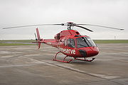 The Aérospatiale TwinStar AS 355 F1, registration ZK-HIT, was using call signs "Police One" with air traffic control and "Eagle" with police control. It was operating out of Mechanics Bay Heliport, the base of the police Air Support Unit, 1 NM east of the central city. The helicopter performed ad-hoc missions around the city, usually at 1,000 feet AMSL, and on 26 November was being piloted by Ross Jeffree Harvey (aged 41), with Police Air Support Unit officers Sergeant Lindsay Eion "Lou" Grant (39) and Constable Alastair Alan Sampson (27). At 4:22 pm it returned to the heliport after a routine mission for a break of about an hour, and was logged taking off again at 5:33 pm. It departed to the north over Waitemata Harbour
and shortly afterwards made a turn to the left to a southwest heading. It flew this course, climbing, for about 1 minute before making a 30° turn to the left, continuing climbing through 1,200 feet until the accident 18 seconds later.
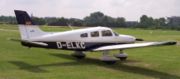 The Piper Archer 28-181, registration ZK-ENX, call sign "Pact 1" (Police Airborne Control of Traffic) was flying a regular weekday traffic patrol, piloted by Allan Anthony Connors (aged 27). The patrols were normally conducted at 1,500 feet. It left Ardmore Aerodrome at 3:59 pm, and reported on several traffic incidents. Shortly after 5:32 pm, the aircraft flew south from the North Shore
to a road accident on the Auckland Southern Motorway
near the Symonds Street on-ramp. It flew southeast past the road accident, and began a turn to the left around the accident site. The aircraft turned through about 270° and was turning through a southwest heading when the collision occurred. The accident interrupted a report the pilot was making to Police Control over the radio.
and Karangahape Road
, at an altitude of about 1,400 feet. The left wing of the Archer separated, and the aircraft rolled, dived steeply, and crashed into the elevated carriageway on the Central Motorway Junction
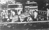
between the Northern and Southern Motorways. The wing landed on a church roof. The TwinStar lost the main rotor and transmission, and rear tail boom, vertical stabiliser, and rear rotor. It fell onto the Grafton Road on-ramp to the Northwestern Motorway, under Symonds Street Bridge, and a severe fire broke out, fuelled by 700 litres of kerosene. The main rotor and tail section fell into a cemetery by Karangahape Road.
Helicopter debris caused moderate facial burns to the driver of a car, who was taken to Auckland City Hospital
. The accident created substantial traffic congestion, which hampered emergency services responding to the scene. A witness at Mount Eden
, 1.3 NM south of the site, caught the accident on video (after the collision).
The U.S. Federal Aviation Administration
conducted a cockpit field of view survey for the Commission. The relative angular position was plotted on the diagram from each aircraft, for 28 seconds prior to the collision. It showed the helicopter would have been visible to the Archer pilot, appearing for about ten seconds in the lower centre windscreen, before being obscured by the engine nose around 18 seconds before the accident. The diagram also showed the low position of the sun may have affected the pilot's ability to see the helicopter. For the TwinStar pilot, the aeroplane would have been visible only for a few seconds in the top left corner of the windscreen. The two observers in the helicopter, sitting in the left front and rear, had no obstruction preventing them seeing the approaching Archer.
The Commission found the Airwork (NZ) Operations Manual specifically addressed collision avoidance between these two aircraft:
Discussions with other pilots of the aircraft and police crew found they were familiar with the normal operating altitudes of 1,500 feet for the Police Traffic Patrol and 1,000 feet for the Police Eagle.
The Commission found the accident occurred because neither pilot saw the other aircraft. Contributing factors were the helicopter not levelling at the agreed altitude, the helicopter did not establish mutual position by radio, and the helicopter crewmembers did not see the traffic in time. It also cited the inherent limitations with the "see and avoid" method as a causal factor. The Commission recommended the Director of Civil Aviation
promulgate a single advisory radio frequency for aircraft in the uncontrolled airspace between Auckland and Whenuapai Control Zones, which he did.
New Zealand
New Zealand is an island country in the south-western Pacific Ocean comprising two main landmasses and numerous smaller islands. The country is situated some east of Australia across the Tasman Sea, and roughly south of the Pacific island nations of New Caledonia, Fiji, and Tonga...
. It occurred on 26 November 1993, when an Aérospatiale TwinStar
Eurocopter AS355
The Eurocopter AS355 Ecureuil 2 is a twin-engine light helicopter originally manufactured by Aérospatiale...
helicopter and a Piper Archer airplane collided and crashed in central Auckland
Auckland
The Auckland metropolitan area , in the North Island of New Zealand, is the largest and most populous urban area in the country with residents, percent of the country's population. Auckland also has the largest Polynesian population of any city in the world...
, killing all four occupants — both civilian pilots and two police officers aboard the helicopter. The accident occurred in daylight with excellent visibility, in uncontrolled airspace
Uncontrolled airspace
Uncontrolled airspace is airspace where an Air Traffic Control service is not deemed necessary or cannot be provided for practical reasons. According to the airspace classes set by ICAO both class F and class G airspace are uncontrolled...
(class G), with both aircraft flying under visual flight rules
Visual flight rules
Visual flight rules are a set of regulations which allow a pilot to operate an aircraft in weather conditions generally clear enough to allow the pilot to see where the aircraft is going. Specifically, the weather must be better than basic VFR weather minimums, as specified in the rules of the...
. Both the helicopter and aeroplane were operated by Airwork (NZ), and working under contract to the New Zealand Police
New Zealand Police
The New Zealand Police is the national police force of New Zealand, responsible for enforcing criminal law, enhancing public safety, maintaining order and keeping the peace throughout New Zealand...
at the time of the accident.
The Transport Accident Investigation Commission
Transport Accident Investigation Commission
The Transport Accident Investigation Commission is a transport safety body of New Zealand. It has its headquarters on the 16th floor of the AXA Centre in Wellington.It was established by Act of the Parliament of New Zealand on 1 September 1990...
investigation found the accident occurred because neither pilot saw the other aircraft.
Aérospatiale aircraft
Waitemata Harbour
The quite famous Waitemata Harbour is the main access by sea to Auckland, New Zealand. For this reason it is often referred to as Auckland Harbour, despite the fact that it is only one of two harbours surrounding the city, and is crossed by the Auckland Harbour Bridge. The Waitemata forms the north...
and shortly afterwards made a turn to the left to a southwest heading. It flew this course, climbing, for about 1 minute before making a 30° turn to the left, continuing climbing through 1,200 feet until the accident 18 seconds later.
Piper aircraft
North Shore, New Zealand
North Shore City was the name of a city that existed in the Auckland region of New Zealand from 1989 until 2010. The city had a population of making it the fourth most populous city in New Zealand prior to November 2010...
to a road accident on the Auckland Southern Motorway
Auckland Southern Motorway
The Auckland Southern Motorway is the major route south out of the Auckland Region of New Zealand. It is part of State Highway 1....
near the Symonds Street on-ramp. It flew southeast past the road accident, and began a turn to the left around the accident site. The aircraft turned through about 270° and was turning through a southwest heading when the collision occurred. The accident interrupted a report the pilot was making to Police Control over the radio.
Collision
The collision occurred at 5:34:48 pm, near the intersection of Queen StreetQueen Street, Auckland
Queen Street is the major commercial thoroughfare in the Auckland CBD, Auckland, New Zealand's main population centre. It starts at Queens Wharf on the Auckland waterfront, adjacent to the Britomart Transport Centre and the Downtown Ferry Terminal, and runs uphill for almost three kilometres in a...
and Karangahape Road
Karangahape Road
Karangahape Road is one of the main streets in the central business district of Auckland, New Zealand. The massive expansion of motorways through the nearby inner city area - and subsequent flight of residents and retail into the suburbs - turned it from one of Auckland's premier shopping streets...
, at an altitude of about 1,400 feet. The left wing of the Archer separated, and the aircraft rolled, dived steeply, and crashed into the elevated carriageway on the Central Motorway Junction
Central Motorway Junction
The Central Motorway Junction or CMJ , is the intersection of New Zealand State Highways 1 and 16, just south of the central business district of Auckland, New Zealand...
between the Northern and Southern Motorways. The wing landed on a church roof. The TwinStar lost the main rotor and transmission, and rear tail boom, vertical stabiliser, and rear rotor. It fell onto the Grafton Road on-ramp to the Northwestern Motorway, under Symonds Street Bridge, and a severe fire broke out, fuelled by 700 litres of kerosene. The main rotor and tail section fell into a cemetery by Karangahape Road.
Helicopter debris caused moderate facial burns to the driver of a car, who was taken to Auckland City Hospital
Auckland City Hospital
The Auckland City Hospital is Auckland's main hospital and the largest hospital in New Zealand, as well as one of the oldest medical facilities of the country. It is a publicly funded hospital, run by the Auckland District Health Board since 2001...
. The accident created substantial traffic congestion, which hampered emergency services responding to the scene. A witness at Mount Eden
Mount Eden
Mount Eden is the name of a cinder cone and surrounding suburb in Auckland City, New Zealand, situated five kilometres south of the city centre. The mountain is the highest natural point in the whole of Auckland...
, 1.3 NM south of the site, caught the accident on video (after the collision).
Investigation
The Transport Accident Investigation Commission was notified of the accident at 6:20 pm, and appointed J J Goddard Investigator in Charge. He began a field investigation later that evening. The wreckage was moved to a storage site prior to inspection, as it was causing a serious obstruction to major public highways. The wreckage inspection found the outboard 50 cm (19.7 in) of the left wing had been cut off the Archer, and found matching damage on one rotor blade of the helicopter, including paint similar to the airplane primer.The U.S. Federal Aviation Administration
Federal Aviation Administration
The Federal Aviation Administration is the national aviation authority of the United States. An agency of the United States Department of Transportation, it has authority to regulate and oversee all aspects of civil aviation in the U.S...
conducted a cockpit field of view survey for the Commission. The relative angular position was plotted on the diagram from each aircraft, for 28 seconds prior to the collision. It showed the helicopter would have been visible to the Archer pilot, appearing for about ten seconds in the lower centre windscreen, before being obscured by the engine nose around 18 seconds before the accident. The diagram also showed the low position of the sun may have affected the pilot's ability to see the helicopter. For the TwinStar pilot, the aeroplane would have been visible only for a few seconds in the top left corner of the windscreen. The two observers in the helicopter, sitting in the left front and rear, had no obstruction preventing them seeing the approaching Archer.
The Commission found the Airwork (NZ) Operations Manual specifically addressed collision avoidance between these two aircraft:
Discussions with other pilots of the aircraft and police crew found they were familiar with the normal operating altitudes of 1,500 feet for the Police Traffic Patrol and 1,000 feet for the Police Eagle.
The Commission found the accident occurred because neither pilot saw the other aircraft. Contributing factors were the helicopter not levelling at the agreed altitude, the helicopter did not establish mutual position by radio, and the helicopter crewmembers did not see the traffic in time. It also cited the inherent limitations with the "see and avoid" method as a causal factor. The Commission recommended the Director of Civil Aviation
Civil Aviation Authority of New Zealand
The Civil Aviation Authority of New Zealand is the government agency tasked with establishing civil aviation safety and security standards in New Zealand....
promulgate a single advisory radio frequency for aircraft in the uncontrolled airspace between Auckland and Whenuapai Control Zones, which he did.