
1975-80 Southern Hemisphere tropical cyclone seasons
Encyclopedia
The 1975-1980 Southern Hemisphere tropical cyclone seasons ran year-round from 1 July to 30 June during each year between 1975 and 1980. Tropical cyclone
activity in the Southern Hemisphere
reaches its peak from mid-February to early March.
Pre-1970
1970-75 1975-80 1980-85 1985-90
Tropical cyclone
A tropical cyclone is a storm system characterized by a large low-pressure center and numerous thunderstorms that produce strong winds and heavy rain. Tropical cyclones strengthen when water evaporated from the ocean is released as the saturated air rises, resulting in condensation of water vapor...
activity in the Southern Hemisphere
Southern Hemisphere
The Southern Hemisphere is the part of Earth that lies south of the equator. The word hemisphere literally means 'half ball' or "half sphere"...
reaches its peak from mid-February to early March.
Pre-1970
Pre-1970 Southern Hemisphere tropical cyclone seasons
The Pre-1970 Southern Hemisphere tropical cyclone seasons ran year-round from July 1 to June 30, reaching their peaks mid-February to early March.Pre-1970 1970–75 1975–80 1980–1985-Unnnamed tropical cyclone :The Banda Islands were hit in March...
1970-75 1975-80 1980-85 1985-90
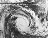
Severe Tropical Cyclone Joan
On the morning of 30 November 1975 satellite imagery showed a large cloud mass in the Timor Sea. The satellite photograph received on the morning of 1 December showed that significant organization had occurred in the cloud mass during the previous 24 hours. It was deemed at 0115 UTC that the system be named the developing cyclone Joan, located about 310 km west-northwest of Darwin. Joan's movement in the following 48 hours was towards the southwest at an average 5 km/h. The first evidence of the increasing strength of Joan came as the cyclone moved west-southwest past the northernmost areas of Western Australia on 3 December. The cyclone's generally west-southwesterly track after 2 December took it away from the coast until 0900 6 December when it was about 420 km north of Port Hedland and the system turned southward. At about 2200 UTC 7 December 1975 the eye of tropical cyclone Joan crossed the coast about 50 km west of Port Hedland. The cyclone was travelling south-southwest at about 14 km/h and crossed over or adjacent to the homesteads on the pastoral properties Mundabullangana, Mallina, Coolawanyah, Hamersley, and Mount Brockman. As cyclone Joan crossed the coastal plain and the Chichester Range only a slow moderation of its intensity seems to have occurred, but as the cyclone crossed the Hamersley Range the available evidence suggests that a rapid weakening took place.Tropical cyclone Joan was the most destructive cyclone to affect the Port Hedland area in more than 30 years. The city was subjected to sustained winds exceeding 90 km/h for about 10 hours with winds in excess of 120 km/h for three hours. The maximum measured wind gust of 208 km/h on 8 December 1975 is the fourth highest on record in Australia. Severe property damage occurred at Port Hedland and at other settlements close to the cyclone's path. Subsequent flooding damaged roads and sections of the iron ore railways, particularly that of Hamersley Iron Pty Ltd. Sheep losses were heavy but, remarkably, no loss of human life or serious injury was reported. The estimated damage to private property and public facilities is believed to have exceeded $25 million.
Cyclone Danae
Cyclone Danae struck Madagascar and then hit the east coast of Mozambique and South Africa in late January 1976. 50 people were killed in the flooding that resulted from the heavy rainfall of Cyclone Danae.WeatherSA Home: Johannesburg
Cyclone Ted
Ted made landfall in QueenslandQueensland
Queensland is a state of Australia, occupying the north-eastern section of the mainland continent. It is bordered by the Northern Territory, South Australia and New South Wales to the west, south-west and south respectively. To the east, Queensland is bordered by the Coral Sea and Pacific Ocean...
on 1 January 1976. The storm killed 2 people and left $49 million dollars in damage.
Cyclone Otto
Otto made landfall near Bowen, QueenslandBowen, Queensland
Bowen is a town on the eastern coast of Queensland, Australia. At the 2006 census, Bowen had a population of 7,484.-Geography:Bowen is located on the north-east coast of Australia, at exactly twenty degrees south of the equator. In fact, the twentieth parallel crosses the main street...
in March 1977. The storm caused minimal wind damage but caused extensive beach erosion.
Cyclone Emilie
Cyclone Emilie struck the east coast of Mozambique and northeastern South Africa in February 1977. Heavy flooding in the Limpopo Valley killed at least 300 people.http://www.blackwell-synergy.com/doi/pdf/10.1111/j.1365-2486.2004.00732.x
http://upetd.up.ac.za/thesis/available/etd-04042002-141358/unrestricted/Dissertation.pdf
Severe Tropical Cyclone Alby
On 27 March a tropical depression developed in the eastern Indian OceanIndian Ocean
The Indian Ocean is the third largest of the world's oceanic divisions, covering approximately 20% of the water on the Earth's surface. It is bounded on the north by the Indian Subcontinent and Arabian Peninsula ; on the west by eastern Africa; on the east by Indochina, the Sunda Islands, and...
between Indonesia
Indonesia
Indonesia , officially the Republic of Indonesia , is a country in Southeast Asia and Oceania. Indonesia is an archipelago comprising approximately 13,000 islands. It has 33 provinces with over 238 million people, and is the world's fourth most populous country. Indonesia is a republic, with an...
and Australia
Australia
Australia , officially the Commonwealth of Australia, is a country in the Southern Hemisphere comprising the mainland of the Australian continent, the island of Tasmania, and numerous smaller islands in the Indian and Pacific Oceans. It is the world's sixth-largest country by total area...
. It drifted to the southwest, and slowly strengthened into a tropical storm on the 29th. Alby continued slowly southwestward, and attained cyclone status on 30 March. The rate of intensification, which was slower earlier in its life, became more steady towards strengthening, and reached the equivalent of Category 3 status on 1 April. Tropical Cyclone Alby turned more to the south, and quickly reached a peak of 135 mph later on 1 April. After maintaining its strength for 30 hours, Alby weakened as it turned to the southeast. Its forward momentum increased over the southeast Indian Ocean, and Alby was only an 85 mph cyclone as it passed off the southwest coast of Australia
Australia
Australia , officially the Commonwealth of Australia, is a country in the Southern Hemisphere comprising the mainland of the Australian continent, the island of Tasmania, and numerous smaller islands in the Indian and Pacific Oceans. It is the world's sixth-largest country by total area...
on 4 April. It continued rapidly to the southeast, and became extratropical on 5 April while south of the continent.
On the 4th of April, Tropical Cyclone Alby passed close to the southwest corner of Western Australia
Western Australia
Western Australia is a state of Australia, occupying the entire western third of the Australian continent. It is bounded by the Indian Ocean to the north and west, the Great Australian Bight and Indian Ocean to the south, the Northern Territory to the north-east and South Australia to the south-east...
, killing five people and causing widespread but mostly minor damage to the southwest. The damage bill was estimated to be $39 million (2003 dollars). A man was blown from the roof of a shed and a woman was killed by a falling pine tree. Another man was killed when a tree fell on the bulldozer he was operating and two men drowned when their dinghy overturned at Albany
Albany, Western Australia
Albany is a port city in the Great Southern region of Western Australia, some 418 km SE of Perth, the state capital. As of 2009, Albany's population was estimated at 33,600, making it the 6th-largest city in the state....
. Storm surge and destructive waves caused coastal inundation and erosion from Perth
Perth, Western Australia
Perth is the capital and largest city of the Australian state of Western Australia and the fourth most populous city in Australia. The Perth metropolitan area has an estimated population of almost 1,700,000....
to Busselton
Busselton, Western Australia
-Growth and development:According to the Australian Bureau of Statistics the Shire had a permanent resident population of 25,950 in 2004 with the town of Busselton accounting for 67% or 17,400 of the total. The Shire's permanent population is expected to continue to increase significantly to...
, damaging the Busselton Jetty and Fremantle Harbour. Fires fanned by the strong winds burned an estimated 1,140 km² of forest and farming land.
Cyclone Peter
Peter caused extensive damage in the Gulf of CarpentariaGulf of Carpentaria
The Gulf of Carpentaria is a large, shallow sea enclosed on three sides by northern Australia and bounded on the north by the Arafura Sea...
between 1 January and 2 January 1979. Peter hovered offshore, causing a 24 hour rainfall of 1140mm/44.88" at Mount Bellenden Ker
Mount Bellenden Ker
Mount Bellenden Ker is the second highest mountain in Queensland, Australia. It is named after the botanist John Bellenden Ker Gawler. Located 60 km south of Cairns near Babinda, it is adjacent to Mount Bartle Frere, the state's highest peak, part of the Bellenden Ker Range which is also...
on 5 January.
Cyclone Kerry
Tropical Cyclone Kerry has the distinction of being the longest lived cyclone in the Australian region. It formed on 13 February 1979 and caused severe damage in the Solomon IslandsSolomon Islands
Solomon Islands is a sovereign state in Oceania, east of Papua New Guinea, consisting of nearly one thousand islands. It covers a land mass of . The capital, Honiara, is located on the island of Guadalcanal...
. It then tracked across the Coral Sea
Coral Sea
The Coral Sea is a marginal sea off the northeast coast of Australia. It is bounded in the west by the east coast of Queensland, thereby including the Great Barrier Reef, in the east by Vanuatu and by New Caledonia, and in the north approximately by the southern extremity of the Solomon Islands...
making landfall near Mackay, Queensland
Mackay, Queensland
Mackay is a city on the eastern coast of Queensland, Australia, about north of Brisbane, on the Pioneer River. Mackay is nicknamed the sugar capital of Australia because its region produces more than a third of Australia's cane sugar....
on 1 March and dissipated on 6 March. Its lowest pressure was 955hPa.
Cyclone Meli
On 27 March 1979, Cyclone Meli brushed Fiji
Fiji
Fiji , officially the Republic of Fiji , is an island nation in Melanesia in the South Pacific Ocean about northeast of New Zealand's North Island...
at peak intensity, causing substantial damage to the island. At least 50 people were killed by the storm.
Cyclone Meli had previously passed through Tuvalu
Tuvalu
Tuvalu , formerly known as the Ellice Islands, is a Polynesian island nation located in the Pacific Ocean, midway between Hawaii and Australia. Its nearest neighbours are Kiribati, Nauru, Samoa and Fiji. It comprises four reef islands and five true atolls...
damaging Funafuti
Funafuti
Funafuti is an atoll that forms the capital of the island nation of Tuvalu. It has a population of 4,492 , making it the most populated atoll in the country. It is a narrow sweep of land between 20 and 400 metres wide, encircling a large lagoon 18 km long and 14 km wide, with a surface of...
atoll.
Cyclone Hazel
Hazel grazed the Western AustraliaWestern Australia
Western Australia is a state of Australia, occupying the entire western third of the Australian continent. It is bounded by the Indian Ocean to the north and west, the Great Australian Bight and Indian Ocean to the south, the Northern Territory to the north-east and South Australia to the south-east...
coast on 1 March 1979. Fifteen crewmen drowned when their fishing boat sank during the storm.
Cyclone Amy
Cyclone Amy struck Western AustraliaWestern Australia
Western Australia is a state of Australia, occupying the entire western third of the Australian continent. It is bounded by the Indian Ocean to the north and west, the Great Australian Bight and Indian Ocean to the south, the Northern Territory to the north-east and South Australia to the south-east...
as a Category 5
Tropical cyclone scales
Tropical systems are officially ranked on one of several tropical cyclone scales according to their maximum sustained winds and in what oceanic basin they are located...
cyclone on 10 January 1980. Amy left $2.7 million dollars ($12 million 2005 AUD) in damage, and injured 5 people.
Cyclone Hyacinthe
Tropical Cyclone Hyacinthe set several worldwide tropical cyclone rainfall records in RéunionRéunion
Réunion is a French island with a population of about 800,000 located in the Indian Ocean, east of Madagascar, about south west of Mauritius, the nearest island.Administratively, Réunion is one of the overseas departments of France...
in the Southwestern Indian Ocean, including a peak total of 5678 mm (223.5 inches).
Tropical Cyclone Dean
Dean struck Western AustraliaWestern Australia
Western Australia is a state of Australia, occupying the entire western third of the Australian continent. It is bounded by the Indian Ocean to the north and west, the Great Australian Bight and Indian Ocean to the south, the Northern Territory to the north-east and South Australia to the south-east...
a month after Cyclone Amy. Dean left $11 million (2005 AUD) in damage. It lasted from 26 January to 4 February 1980.
Cyclone Enid
Enid lasted from 12 to 18 February 1980 and made landfall between Port Hedland and Broome, Western AustraliaBroome, Western Australia
Broome is a pearling and tourist town in the Kimberley region of Western Australia, north of Perth. The year round population is approximately 14,436, growing to more than 45,000 per month during the tourist season...
(near Shay Gap) and caused flooding.