
1973 Pacific typhoon season
Encyclopedia
The 1973 Pacific typhoon season has no official bounds, but most tropical cyclones tend to form in the northwestern Pacific Ocean between June and December. These dates conventionally delimit the period of each year when most tropical cyclones form in the northwestern Pacific Ocean.
The scope of this article is limited to the Pacific Ocean, north of the equator and west of the international date line
. Storms that form east of the date line and north of the equator are called hurricanes; see 1973 Pacific hurricane season
. Tropical Storms formed in the entire west pacific basin were assigned a name by the Joint Typhoon Warning Center
. Tropical depressions in this basin have the "W" suffix added to their number. Tropical depressions that enter or form in the Philippine area of responsibility are assigned a name by the Philippine Atmospheric, Geophysical and Astronomical Services Administration
or PAGASA. This can often result in the same storm having two names.
, rapidly strengthened on the 14th and 15th to a 150 mph super typhoon. It tracked due north, fluctuating in intensity for the next 3 days. A building ridge over the Sea of Japan
forced Billie to the northwest, where it weakened greatly, first to a tropical storm on the 18th, then to a tropical depression on the 19th as it passes over northeastern China. The storm dissipated on the 20th.
on the 7th as a 115 mph typhoon. Nora continued to the northwest, weakening to a minimal typhoon as it hit southeast China on the 10th. The typhoon caused 18 fatalities, with over $2 million in damage.
. The first storm of 1973 was named Wilda and the final one was named Vera.
{|width="90%"
|
The scope of this article is limited to the Pacific Ocean, north of the equator and west of the international date line
International Date Line
The International Date Line is a generally north-south imaginary line on the surface of the Earth, passing through the middle of the Pacific Ocean, that designates the place where each calendar day begins...
. Storms that form east of the date line and north of the equator are called hurricanes; see 1973 Pacific hurricane season
1973 Pacific hurricane season
The 1973 Pacific hurricane season was an event in tropical cyclone meteorology. The most important system this year was Hurricane Ava, which was the most intense Pacific hurricane known at the time. Several other much weaker tropical cyclones came close to, or made landfall on, the Pacific coast of...
. Tropical Storms formed in the entire west pacific basin were assigned a name by the Joint Typhoon Warning Center
Joint Typhoon Warning Center
The Joint Typhoon Warning Center is a joint United States Navy – United States Air Force task force located at the Naval Maritime Forecast Center in Pearl Harbor, Hawaii...
. Tropical depressions in this basin have the "W" suffix added to their number. Tropical depressions that enter or form in the Philippine area of responsibility are assigned a name by the Philippine Atmospheric, Geophysical and Astronomical Services Administration
Philippine Atmospheric, Geophysical and Astronomical Services Administration
The Philippine Atmospheric, Geophysical and Astronomical Services Administration is a Philippine national institution dedicated to provide flood and typhoon warnings, public weather forecasts and advisories, meteorological, astronomical, climatological, and other specialized information and...
or PAGASA. This can often result in the same storm having two names.
Storms
23 tropical depressions formed this year in the Western Pacific, of which 21 became tropical storms. 12 storms reached typhoon intensity, of which 3 reached super typhoon strength.Super Typhoon Billie (Bining)
Tropical Storm Bille, which developed on July 12 east of the PhilippinesPhilippines
The Philippines , officially known as the Republic of the Philippines , is a country in Southeast Asia in the western Pacific Ocean. To its north across the Luzon Strait lies Taiwan. West across the South China Sea sits Vietnam...
, rapidly strengthened on the 14th and 15th to a 150 mph super typhoon. It tracked due north, fluctuating in intensity for the next 3 days. A building ridge over the Sea of Japan
Sea of Japan
The Sea of Japan is a marginal sea of the western Pacific Ocean, between the Asian mainland, the Japanese archipelago and Sakhalin. It is bordered by Japan, North Korea, Russia and South Korea. Like the Mediterranean Sea, it has almost no tides due to its nearly complete enclosure from the Pacific...
forced Billie to the northwest, where it weakened greatly, first to a tropical storm on the 18th, then to a tropical depression on the 19th as it passes over northeastern China. The storm dissipated on the 20th.
Typhoon Dot
Typhoon Dot struck Hong Kong causing sustained storm force winds, killing one person.Super Typhoon Nora (Luming)
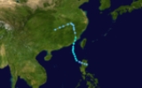
The monsoon trough spawned a tropical depression east of the Philippines on October 1. Under weak steering currents, it meandered westward, where favorable conditions allowed for it to strengthen, first to a tropical storm on the 2nd, then to a typhoon on the 3rd. Nora continued to the northwest, and explosively deepened on the 5th and 6th to a 185 mph super typhoon. At the time, it had a minimum central pressure of 877 millibars, the lowest pressure on record at the time and currently tied for 9th. The typhoon weakened as it headed to the northwest, and struck northeastern LuzonLuzon
Luzon is the largest island in the Philippines. It is located in the northernmost region of the archipelago, and is also the name for one of the three primary island groups in the country centered on the Island of Luzon...
on the 7th as a 115 mph typhoon. Nora continued to the northwest, weakening to a minimal typhoon as it hit southeast China on the 10th. The typhoon caused 18 fatalities, with over $2 million in damage.
Typhoon Ruth (Narsing)
27 people were killed when Typhoon Ruth crossed Luzon on October 15 and caused $5 million in damage. Ruth continued to the northwest, and hit Hainan Island and China on the 19th and 20th, respectively.Tropical Storm Sarah
On November 12 this system emerged in the Bay of Bengal and became Tropical Cyclone 37-73.1973 storm names
Western North Pacific tropical cyclones were named by the Joint Typhoon Warning CenterJoint Typhoon Warning Center
The Joint Typhoon Warning Center is a joint United States Navy – United States Air Force task force located at the Naval Maritime Forecast Center in Pearl Harbor, Hawaii...
. The first storm of 1973 was named Wilda and the final one was named Vera.
{|width="90%"
|
The 1973 Pacific typhoon season has no official bounds, but most tropical cyclones tend to form in the northwestern Pacific Ocean between June and December. These dates conventionally delimit the period of each year when most tropical cyclones form in the northwestern Pacific Ocean.
The scope of this article is limited to the Pacific Ocean, north of the equator and west of the international date line
International Date Line
The International Date Line is a generally north-south imaginary line on the surface of the Earth, passing through the middle of the Pacific Ocean, that designates the place where each calendar day begins...
. Storms that form east of the date line and north of the equator are called hurricanes; see 1973 Pacific hurricane season
1973 Pacific hurricane season
The 1973 Pacific hurricane season was an event in tropical cyclone meteorology. The most important system this year was Hurricane Ava, which was the most intense Pacific hurricane known at the time. Several other much weaker tropical cyclones came close to, or made landfall on, the Pacific coast of...
. Tropical Storms formed in the entire west pacific basin were assigned a name by the Joint Typhoon Warning Center
Joint Typhoon Warning Center
The Joint Typhoon Warning Center is a joint United States Navy – United States Air Force task force located at the Naval Maritime Forecast Center in Pearl Harbor, Hawaii...
. Tropical depressions in this basin have the "W" suffix added to their number. Tropical depressions that enter or form in the Philippine area of responsibility are assigned a name by the Philippine Atmospheric, Geophysical and Astronomical Services Administration
Philippine Atmospheric, Geophysical and Astronomical Services Administration
The Philippine Atmospheric, Geophysical and Astronomical Services Administration is a Philippine national institution dedicated to provide flood and typhoon warnings, public weather forecasts and advisories, meteorological, astronomical, climatological, and other specialized information and...
or PAGASA. This can often result in the same storm having two names.
Storms
23 tropical depressions formed this year in the Western Pacific, of which 21 became tropical storms. 12 storms reached typhoon intensity, of which 3 reached super typhoon strength.Super Typhoon Billie (Bining)
Tropical Storm Bille, which developed on July 12 east of the PhilippinesPhilippines
The Philippines , officially known as the Republic of the Philippines , is a country in Southeast Asia in the western Pacific Ocean. To its north across the Luzon Strait lies Taiwan. West across the South China Sea sits Vietnam...
, rapidly strengthened on the 14th and 15th to a 150 mph super typhoon. It tracked due north, fluctuating in intensity for the next 3 days. A building ridge over the Sea of Japan
Sea of Japan
The Sea of Japan is a marginal sea of the western Pacific Ocean, between the Asian mainland, the Japanese archipelago and Sakhalin. It is bordered by Japan, North Korea, Russia and South Korea. Like the Mediterranean Sea, it has almost no tides due to its nearly complete enclosure from the Pacific...
forced Billie to the northwest, where it weakened greatly, first to a tropical storm on the 18th, then to a tropical depression on the 19th as it passes over northeastern China. The storm dissipated on the 20th.
Typhoon Dot
Typhoon Dot struck Hong Kong causing sustained storm force winds, killing one person.Super Typhoon Nora (Luming)
The monsoon trough spawned a tropical depression east of the Philippines on October 1. Under weak steering currents, it meandered westward, where favorable conditions allowed for it to strengthen, first to a tropical storm on the 2nd, then to a typhoon on the 3rd. Nora continued to the northwest, and explosively deepened on the 5th and 6th to a 185 mph super typhoon. At the time, it had a minimum central pressure of 877 millibars, the lowest pressure on record at the time and currently tied for 9th. The typhoon weakened as it headed to the northwest, and struck northeastern LuzonLuzon
Luzon is the largest island in the Philippines. It is located in the northernmost region of the archipelago, and is also the name for one of the three primary island groups in the country centered on the Island of Luzon...
on the 7th as a 115 mph typhoon. Nora continued to the northwest, weakening to a minimal typhoon as it hit southeast China on the 10th. The typhoon caused 18 fatalities, with over $2 million in damage.
Typhoon Ruth (Narsing)
27 people were killed when Typhoon Ruth crossed Luzon on October 15 and caused $5 million in damage. Ruth continued to the northwest, and hit Hainan Island and China on the 19th and 20th, respectively.Tropical Storm Sarah
On November 12 this system emerged in the Bay of Bengal and became Tropical Cyclone 37-73.1973 storm names
Western North Pacific tropical cyclones were named by the Joint Typhoon Warning CenterJoint Typhoon Warning Center
The Joint Typhoon Warning Center is a joint United States Navy – United States Air Force task force located at the Naval Maritime Forecast Center in Pearl Harbor, Hawaii...
. The first storm of 1973 was named Wilda and the final one was named Vera.
{|width="90%"
|
- AgnesBessCarmenDellaElaineFayeGloriaHesterIrmaJudyKitLolaMamieNinaOraPhylliRitaSusanTessViolaWinnie
|- AliceBettyCoraDorisElsieFlossieGraceHelenIdaJuneKathyLornaMarieNancyOlgaPamelaRubySallyThereseViolet
- Wilda 1W
|- Anita 2W
- Billie 4W
- Clara 3W
- Dot 5W
- Ellen 6W
- Fran 7W
- Georgia 8W
- Hope 9W
- Iris 10W
- Joan 12W
- Kate 13W
- Louise 15W
- Marge 16W
- Nora 17W
- Opal 18W
- Patsy 19W
- Ruth 20W
- Sarah 21W
- Thelma 22W
- Vera 23W
- Wanda
|- AmyBabeCarlaDinahEmmaFredaGildaHarrietIvyJeanKimLucyMaryNadineOlivePollyRoseShirleyTrixVirginiaWendy
|}
See also
- 1973 Pacific hurricane season1973 Pacific hurricane seasonThe 1973 Pacific hurricane season was an event in tropical cyclone meteorology. The most important system this year was Hurricane Ava, which was the most intense Pacific hurricane known at the time. Several other much weaker tropical cyclones came close to, or made landfall on, the Pacific coast of...
- 1973 Atlantic hurricane season1973 Atlantic hurricane seasonThe 1973 Atlantic hurricane season was the first season to use the Saffir-Simpson Hurricane Scale, a scale developed in 1971 by Herbert Saffir and Robert Simpson used for rating the intensity of tropical cyclones. The season produced 24 tropical and subtropical cyclones, of which only 8 reached...
External links
- Japan Meteorological Agency
- Joint Typhoon Warning Center.
- China Meteorological Agency
- National Weather Service Guam
- Hong Kong Observatory
- Macau Meteorological Geophysical Services
- Korea Meteorological Agency
- Philippine Atmospheric, Geophysical and Astronomical Services Administration
- Taiwan Central Weather Bureau
- Digital Typhoon - Typhoon Images and Information
- Typhoon2000 Philippine typhoon website

-