
1939 Long Beach Tropical Storm
Encyclopedia
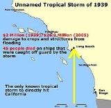
The 1939 California tropical storm, also called the 1939 Long Beach Tropical Storm, El Cordonazo, The Lash of St. Francis was a tropical cyclone that hit Southern California
in September, 1939. Formerly a hurricane, it was the only tropical storm to make landfall
in California in the twentieth century. The only other known tropical cyclone to directly affect California is the 1858 San Diego Hurricane
, and only three other eastern Pacific tropical cyclone
s have caused gale-force winds in the continental United States. The tropical storm caused heavy flooding, leaving many dead, mostly at sea.
. It then turned north and then north-eastward. For some time, it was a hurricane, and it lost that intensity on or just before September 25. The tropical storm made landfall near San Pedro, California early on September 25 with winds of severe gale strength. It dissipated later that day. The strongest reported wind was of Force 11
, reported by a ship, making this system a minimal hurricane. The lowest pressure was reported by the same ship and was 28.67 inHg (971 mb).
Due to the rotation of the Earth
, tropical cyclones in the Northern Hemisphere tend to move from east to west. This causes tropical cyclones to approach the West Coast of the United States
infrequently. Another inhibiting factor for a California landfall is the water temperatures. Because of the water currents, the waters off California are rarely above 70 °F (21.1 °C), which is too cold for hurricanes to sustain themselves. This tropical cyclone was rare enough that only three other eastern Pacific tropical cyclones brought tropical storm-force winds to the Continental United States during the twentieth century. The Long Beach Tropical Storm was the only one to make landfall; the other three hit Mexico before moving north.
 The storm dropped heavy rain on California, with 5.66 inches (144 mm) falling in Los Angeles
(5.24 inches in 24 hours) and 11.6 inches (294.6 mm) recorded at Mount Wilson
, both September records. Over three hours, one thunderstorm dropped nearly 7 inches (177.8 mm) of rain on Indio
. 9.65 inches fell on Raywood Flat, and 1.51 inches (38.4 mm) on Palm Springs
. 4.83 inches fell on Pasadena
, a September record at the time. At the Citrus Belt near Anaheim
, at least 4.63 inches of rain fell. The 11.6 inches (294.6 mm) at Mount Wilson is one of California's highest rainfall amounts from a tropical cyclone, although at least one system has a higher point maximum. The rains caused a flood 2 to 4 feet (1.2 m) deep in the Coachella Valley
, although some of this may be attributable to a rainstorm dropping 6.45 inches (164 mm) the day before the storm hit. The Los Angeles River
, which was usually low during September, became a raging torrent.
The flooding killed 45 in Southern California, although some of these may be attributable to the rain immediately before the tropical storm. At sea, 48 were killed. The National Hurricane Center
only attributes 45 deaths to this system. Six people caught on beaches drowned during the storm. Most other deaths were at sea. Twenty-four died aboard a vessel called the Spray as it attempted to dock at Point Mugu
. The two survivors, a man and a woman, swam ashore and then walked five miles (8 km) to Oxnard
. Fifteen people from Ventura
drowned aboard a fishing boat called the Lur. Many other vessels were sunk, capsized, or blown ashore.
Many low-lying areas were flooded. The Hamilton Bowl overflowed, flooding the Signal Hill
area. Along the shore from Malibu to Huntington Beach
houses were flooded. Throughout the area, thousands of people were stranded in their homes. Streets in Los Angeles proper
were covered with water, flooding buildings and stalling cars. Flooding in Inglewood
and Los Angeles reached a depth of 2 to 3 feet. Construction on a flood control project in the Los Angeles River's channel by the Army Corps of Engineers was stopped by the flooding. In Long Beach
windows throughout that city were smashed by the wind. At Belmont Shore, waves undermined ten homes before washing them away. Debris was scattered throughout the coast. Agriculture was disrupted. Crop damage in the Coachella Valley reached 75%.
Rains washed away a 150 feet (45.7 m) section of the Southern Pacific Railroad
near Indio
, and a stretch of the Santa Fe main line near Needles
. Waters backing up from a storm drain under construction in the Santa Monica Valley blocked U.S. Route 6 in California
. The pier
at Point Mugu was washed away. In Pasadena, 5000 people were left without electricity and 2000 telephones lost service. Communications throughout the affected area was disrupted or rendered impossible. The total amount of damage was $2 million (1939 USD, $26.2 million 2005 USD).
The tropical storm was credited with at least one beneficial effect: it ended a vicious heat wave
that had lasted for over a week and killed at least ninety people.
People were caught unprepared by the storm, which was described as "sudden". Some people were still on the beach at Long Beach when the wind reached 40 miles per hour, at which time lifeguards closed the beach. Schools were closed there. Out at sea, the Coast Guard
and Navy
conducted rescue operations, saving dozens of people. In response to Californians' unpreparedness, the Weather Bureau established a forecast office for southern California, which began operations in February 1940.
Southern California
Southern California is a megaregion, or megapolitan area, in the southern area of the U.S. state of California. Large urban areas include Greater Los Angeles and Greater San Diego. The urban area stretches along the coast from Ventura through the Southland and Inland Empire to San Diego...
in September, 1939. Formerly a hurricane, it was the only tropical storm to make landfall
Landfall (meteorology)
Landfall is the event of a tropical cyclone or a waterspout coming onto land after being over water. When a waterspout makes landfall it is reclassified as a tornado, which can then cause damage inland...
in California in the twentieth century. The only other known tropical cyclone to directly affect California is the 1858 San Diego Hurricane
1858 San Diego Hurricane
The 1858 San Diego hurricane was a very rare California hurricane. It is the only known tropical cyclone to impact California as a hurricane, although other systems impacted California as tropical storms.-Meteorological history:...
, and only three other eastern Pacific tropical cyclone
Tropical cyclone
A tropical cyclone is a storm system characterized by a large low-pressure center and numerous thunderstorms that produce strong winds and heavy rain. Tropical cyclones strengthen when water evaporated from the ocean is released as the saturated air rises, resulting in condensation of water vapor...
s have caused gale-force winds in the continental United States. The tropical storm caused heavy flooding, leaving many dead, mostly at sea.
Meteorological history
On September 15, a tropical depression formed off the coast of Central America. It moved west-northwest, passing southwest of the Revillagigedo IslandsRevillagigedo Islands
The Revillagigedo Islands or Revillagigedo Archipelago are a group of four volcanic islands in the Pacific Ocean, known for their unique ecosystem...
. It then turned north and then north-eastward. For some time, it was a hurricane, and it lost that intensity on or just before September 25. The tropical storm made landfall near San Pedro, California early on September 25 with winds of severe gale strength. It dissipated later that day. The strongest reported wind was of Force 11
Beaufort scale
The Beaufort Scale is an empirical measure that relates wind speed to observed conditions at sea or on land. Its full name is the Beaufort Wind Force Scale.-History:...
, reported by a ship, making this system a minimal hurricane. The lowest pressure was reported by the same ship and was 28.67 inHg (971 mb).
Due to the rotation of the Earth
Earth
Earth is the third planet from the Sun, and the densest and fifth-largest of the eight planets in the Solar System. It is also the largest of the Solar System's four terrestrial planets...
, tropical cyclones in the Northern Hemisphere tend to move from east to west. This causes tropical cyclones to approach the West Coast of the United States
West Coast of the United States
West Coast or Pacific Coast are terms for the westernmost coastal states of the United States. The term most often refers to the states of California, Oregon, and Washington. Although not part of the contiguous United States, Alaska and Hawaii do border the Pacific Ocean but can't be included in...
infrequently. Another inhibiting factor for a California landfall is the water temperatures. Because of the water currents, the waters off California are rarely above 70 °F (21.1 °C), which is too cold for hurricanes to sustain themselves. This tropical cyclone was rare enough that only three other eastern Pacific tropical cyclones brought tropical storm-force winds to the Continental United States during the twentieth century. The Long Beach Tropical Storm was the only one to make landfall; the other three hit Mexico before moving north.
Impact
Los Ángeles
Los Ángeles is the capital of the province of Biobío, in the commune of the same name, in Region VIII , in the center-south of Chile. It is located between the Laja and Biobío rivers. The population is 123,445 inhabitants...
(5.24 inches in 24 hours) and 11.6 inches (294.6 mm) recorded at Mount Wilson
Mount Wilson (California)
Mount Wilson is one of the better known peaks in the San Gabriel Mountains, part of the Angeles National Forest in Los Angeles County, California. It is the location of the Mount Wilson Observatory and has become the astronomical center of Southern California with and telescopes, and and tall...
, both September records. Over three hours, one thunderstorm dropped nearly 7 inches (177.8 mm) of rain on Indio
Indio, California
Indio is a city in Riverside County, California, United States, located in the Coachella Valley of Southern California's Colorado Desert region. It lies east of Palm Springs, east of Riverside, and east of Los Angeles. It is about north of Mexicali, Baja California on the U.S.-Mexican border...
. 9.65 inches fell on Raywood Flat, and 1.51 inches (38.4 mm) on Palm Springs
Palm Springs, California
Palm Springs is a desert city in Riverside County, California, within the Coachella Valley. It is located approximately 37 miles east of San Bernardino, 111 miles east of Los Angeles and 136 miles northeast of San Diego...
. 4.83 inches fell on Pasadena
Pasadena, California
Pasadena is a city in Los Angeles County, California, United States. Although famous for hosting the annual Rose Bowl football game and Tournament of Roses Parade, Pasadena is the home to many scientific and cultural institutions, including the California Institute of Technology , the Jet...
, a September record at the time. At the Citrus Belt near Anaheim
Anaheim, California
Anaheim is a city in Orange County, California. As of the 2010 United States Census, the city population was about 365,463, making it the most populated city in Orange County, the 10th most-populated city in California, and ranked 54th in the United States...
, at least 4.63 inches of rain fell. The 11.6 inches (294.6 mm) at Mount Wilson is one of California's highest rainfall amounts from a tropical cyclone, although at least one system has a higher point maximum. The rains caused a flood 2 to 4 feet (1.2 m) deep in the Coachella Valley
Coachella Valley
Coachella Valley is a large valley landform in Southern California. The valley extends for approximately 45 miles in Riverside County southeast from the San Bernardino Mountains to the saltwater Salton Sea, the largest lake in California...
, although some of this may be attributable to a rainstorm dropping 6.45 inches (164 mm) the day before the storm hit. The Los Angeles River
Los Angeles River
The Los Angeles River is a river that starts in the San Fernando Valley, in the Simi Hills and Santa Susana Mountains, and flows through Los Angeles County, California, from Canoga Park in the western end of the San Fernando Valley, nearly southeast to its mouth in Long Beach...
, which was usually low during September, became a raging torrent.
The flooding killed 45 in Southern California, although some of these may be attributable to the rain immediately before the tropical storm. At sea, 48 were killed. The National Hurricane Center
National Hurricane Center
The National Hurricane Center , located at Florida International University in Miami, Florida, is the division of the National Weather Service responsible for tracking and predicting weather systems within the tropics between the Prime Meridian and the 140th meridian west poleward to the 30th...
only attributes 45 deaths to this system. Six people caught on beaches drowned during the storm. Most other deaths were at sea. Twenty-four died aboard a vessel called the Spray as it attempted to dock at Point Mugu
Point Mugu, California
Point Mugu , California is an unincorporated area and geographical promontory on the Pacific coast in Ventura County, near the town of Port Hueneme and the city of Oxnard. The name is believed to be derived from the Chumash Indian term Muwu, meaning beach, which was first mentioned by Cabrillo in...
. The two survivors, a man and a woman, swam ashore and then walked five miles (8 km) to Oxnard
Oxnard, California
Oxnard is the 113th largest city in the United States, 19th largest city in California and largest city in Ventura County, California, by way of population. It is located at the western edge of the fertile Oxnard Plain, and is an important agricultural center, with its distinction as the...
. Fifteen people from Ventura
Ventura, California
Ventura is the county seat of Ventura County, California, United States, incorporated in 1866. The population was 106,433 at the 2010 census, up from 100,916 at the 2000 census. Ventura is accessible via U.S...
drowned aboard a fishing boat called the Lur. Many other vessels were sunk, capsized, or blown ashore.
Many low-lying areas were flooded. The Hamilton Bowl overflowed, flooding the Signal Hill
Signal Hill, California
Signal Hill is a small city in California located in the Greater Los Angeles area. Signal Hill, completely surrounded by the city of Long Beach, was incorporated on April 22, 1924, roughly three years after oil was discovered in Signal Hill. As of the 2010 census, the city population was...
area. Along the shore from Malibu to Huntington Beach
Huntington Beach, California
Huntington Beach is a seaside city in Orange County in Southern California. According to the 2010 census, the city population was 189,992; making it the largest beach city in Orange County in terms of population...
houses were flooded. Throughout the area, thousands of people were stranded in their homes. Streets in Los Angeles proper
Los Angeles, California
Los Angeles , with a population at the 2010 United States Census of 3,792,621, is the most populous city in California, USA and the second most populous in the United States, after New York City. It has an area of , and is located in Southern California...
were covered with water, flooding buildings and stalling cars. Flooding in Inglewood
Inglewood, California
Inglewood is a city in southwestern Los Angeles County, California, southwest of downtown Los Angeles. It was incorporated on February 14, 1908. Its population stood at 109,673 as of the 2010 Census...
and Los Angeles reached a depth of 2 to 3 feet. Construction on a flood control project in the Los Angeles River's channel by the Army Corps of Engineers was stopped by the flooding. In Long Beach
Long Beach, California
Long Beach is a city situated in Los Angeles County in Southern California, on the Pacific coast of the United States. The city is the 36th-largest city in the nation and the seventh-largest in California. As of 2010, its population was 462,257...
windows throughout that city were smashed by the wind. At Belmont Shore, waves undermined ten homes before washing them away. Debris was scattered throughout the coast. Agriculture was disrupted. Crop damage in the Coachella Valley reached 75%.
Rains washed away a 150 feet (45.7 m) section of the Southern Pacific Railroad
Southern Pacific Railroad
The Southern Pacific Transportation Company , earlier Southern Pacific Railroad and Southern Pacific Company, and usually simply called the Southern Pacific or Espee, was an American railroad....
near Indio
Indio, California
Indio is a city in Riverside County, California, United States, located in the Coachella Valley of Southern California's Colorado Desert region. It lies east of Palm Springs, east of Riverside, and east of Los Angeles. It is about north of Mexicali, Baja California on the U.S.-Mexican border...
, and a stretch of the Santa Fe main line near Needles
Needles, California
Needles is a city located in the Mojave Desert on the western banks of the Colorado River in San Bernardino County, California. It is located in the Mohave Valley, which straddles the California–Arizona border. The city is accessible via Interstate 40 and U.S. Route 95...
. Waters backing up from a storm drain under construction in the Santa Monica Valley blocked U.S. Route 6 in California
U.S. Route 6 in California
U.S. Route 6, or US 6, is a transcontinental highway from the U.S. state of California to Massachusetts. In California, the highway lies in the eastern portion of the state from Bishop in the Owens Valley north to the Nevada state line in Esmeralda County...
. The pier
Pier
A pier is a raised structure, including bridge and building supports and walkways, over water, typically supported by widely spread piles or pillars...
at Point Mugu was washed away. In Pasadena, 5000 people were left without electricity and 2000 telephones lost service. Communications throughout the affected area was disrupted or rendered impossible. The total amount of damage was $2 million (1939 USD, $26.2 million 2005 USD).
The tropical storm was credited with at least one beneficial effect: it ended a vicious heat wave
Heat wave
A heat wave is a prolonged period of excessively hot weather, which may be accompanied by high humidity. There is no universal definition of a heat wave; the term is relative to the usual weather in the area...
that had lasted for over a week and killed at least ninety people.
People were caught unprepared by the storm, which was described as "sudden". Some people were still on the beach at Long Beach when the wind reached 40 miles per hour, at which time lifeguards closed the beach. Schools were closed there. Out at sea, the Coast Guard
United States Coast Guard
The United States Coast Guard is a branch of the United States Armed Forces and one of the seven U.S. uniformed services. The Coast Guard is a maritime, military, multi-mission service unique among the military branches for having a maritime law enforcement mission and a federal regulatory agency...
and Navy
United States Navy
The United States Navy is the naval warfare service branch of the United States Armed Forces and one of the seven uniformed services of the United States. The U.S. Navy is the largest in the world; its battle fleet tonnage is greater than that of the next 13 largest navies combined. The U.S...
conducted rescue operations, saving dozens of people. In response to Californians' unpreparedness, the Weather Bureau established a forecast office for southern California, which began operations in February 1940.
See also
- List of tropical cyclones
- List of California tropical storms
- List of wettest tropical cyclones in California