
1913 Atlantic hurricane season
Encyclopedia
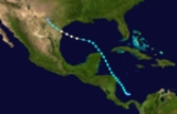
The 1913 Atlantic hurricane season was a relatively inactive Atlantic hurricane season
during which six tropical cyclone
s formed, four of which became hurricanes. The first storm developed on June 22, and the last dissipated on October 30. The official start of the season is generally considered to be June 1 with the end being October 31. Due to increased activity over the following decades, the official end of the hurricane season was shifted to November 30.
hurricane that struck Cancún
, Mexico
and Padre Island
, Texas
. The storm produced torrential rains which peaked in Montell, Texas as 20.6 in (523.24 m). At the time this was recorded, it was the highest 24 hour rainfall event recorded in Texas. The rains triggered damaging flooding which killed one person and damaging several buildings. Communications to the area were disrupted for several days following the storm.
on August 26. It took a long track through the Atlantic. The storm nearly became a hurricane. Tropical Storm Three dissipated on September 12.
that came ashore near Cape Lookout, North Carolina. The storm produced heavy rains amounting to 2–5 in (51–127 mm) and high winds, mainly along the coastline. Water levels along the coast rose in excess of 10 ft (3 m), causing significant flooding. In Farmville, North Carolina
, a warehouse collapsed, killing two boys inside. Three other people were killed in the state. About a mile (1.6 km) of roadways and bridges were washed away by the storm. Crops sustained significant damage throughout the state. Total property losses were estimated at $4–5 million.
. Although the storm had been a hurricane at landfall, the highest recorded winds were 37 mph (60 km/h). Heavy rains, peaking at 4.88 in (123.95 mm), were recoded along the coast of South Carolina. Little or no damage was reported as a result of the storm.
and east of the Yucatan Peninsula
on October 28. The storm made landfall in Cuba and dissipated on October 30.
Atlantic hurricane season
The Atlantic hurricane season is the period in a year when hurricanes usually form in the Atlantic Ocean. Tropical cyclones in the North Atlantic are called hurricanes, tropical storms, or tropical depressions. In addition, there have been several storms over the years that have not been fully...
during which six tropical cyclone
Tropical cyclone
A tropical cyclone is a storm system characterized by a large low-pressure center and numerous thunderstorms that produce strong winds and heavy rain. Tropical cyclones strengthen when water evaporated from the ocean is released as the saturated air rises, resulting in condensation of water vapor...
s formed, four of which became hurricanes. The first storm developed on June 22, and the last dissipated on October 30. The official start of the season is generally considered to be June 1 with the end being October 31. Due to increased activity over the following decades, the official end of the hurricane season was shifted to November 30.
Hurricane One
The first storm of the season was a Category 1Saffir-Simpson Hurricane Scale
The Saffir–Simpson Hurricane Scale , or the Saffir–Simpson Hurricane Wind Scale , classifies hurricanes — Western Hemisphere tropical cyclones that exceed the intensities of tropical depressions and tropical storms — into five categories distinguished by the intensities of their sustained winds...
hurricane that struck Cancún
Cancún
Cancún is a city of international tourism development certified by the UNWTO . Located on the northeast coast of Quintana Roo in southern Mexico, more than 1,700 km from Mexico City, the Project began operations in 1974 as Integrally Planned Center, a pioneer of FONATUR Cancún is a city of...
, Mexico
Mexico
The United Mexican States , commonly known as Mexico , is a federal constitutional republic in North America. It is bordered on the north by the United States; on the south and west by the Pacific Ocean; on the southeast by Guatemala, Belize, and the Caribbean Sea; and on the east by the Gulf of...
and Padre Island
Padre Island
Padre Island is part of the U.S. state of Texas. The island is located on Texas' southern coast of the Gulf of Mexico and is famous for its white sandy beaches at the south end...
, Texas
Texas
Texas is the second largest U.S. state by both area and population, and the largest state by area in the contiguous United States.The name, based on the Caddo word "Tejas" meaning "friends" or "allies", was applied by the Spanish to the Caddo themselves and to the region of their settlement in...
. The storm produced torrential rains which peaked in Montell, Texas as 20.6 in (523.24 m). At the time this was recorded, it was the highest 24 hour rainfall event recorded in Texas. The rains triggered damaging flooding which killed one person and damaging several buildings. Communications to the area were disrupted for several days following the storm.
Tropical Storm Two
Tropical Storm Two form in the open Atlantic and dissipated two days later.Tropical Storm Three
Tropical Storm Three formed near AfricaAfrica
Africa is the world's second largest and second most populous continent, after Asia. At about 30.2 million km² including adjacent islands, it covers 6% of the Earth's total surface area and 20.4% of the total land area...
on August 26. It took a long track through the Atlantic. The storm nearly became a hurricane. Tropical Storm Three dissipated on September 12.
Hurricane Four
The fourth storm was a Category 1Saffir-Simpson Hurricane Scale
The Saffir–Simpson Hurricane Scale , or the Saffir–Simpson Hurricane Wind Scale , classifies hurricanes — Western Hemisphere tropical cyclones that exceed the intensities of tropical depressions and tropical storms — into five categories distinguished by the intensities of their sustained winds...
that came ashore near Cape Lookout, North Carolina. The storm produced heavy rains amounting to 2–5 in (51–127 mm) and high winds, mainly along the coastline. Water levels along the coast rose in excess of 10 ft (3 m), causing significant flooding. In Farmville, North Carolina
Farmville, North Carolina
Farmville is a town in Pitt County, North Carolina, eight miles to the west of Greenville, North Carolina. According to a census taken in 2008 the estimated population is 4,615...
, a warehouse collapsed, killing two boys inside. Three other people were killed in the state. About a mile (1.6 km) of roadways and bridges were washed away by the storm. Crops sustained significant damage throughout the state. Total property losses were estimated at $4–5 million.
Hurricane Five
The fifth storm of the season was a hurricane that hit Charleston, South CarolinaCharleston, South Carolina
Charleston is the second largest city in the U.S. state of South Carolina. It was made the county seat of Charleston County in 1901 when Charleston County was founded. The city's original name was Charles Towne in 1670, and it moved to its present location from a location on the west bank of the...
. Although the storm had been a hurricane at landfall, the highest recorded winds were 37 mph (60 km/h). Heavy rains, peaking at 4.88 in (123.95 mm), were recoded along the coast of South Carolina. Little or no damage was reported as a result of the storm.
Hurricane Six
This storm form north of HondurasHonduras
Honduras is a republic in Central America. It was previously known as Spanish Honduras to differentiate it from British Honduras, which became the modern-day state of Belize...
and east of the Yucatan Peninsula
Yucatán Peninsula
The Yucatán Peninsula, in southeastern Mexico, separates the Caribbean Sea from the Gulf of Mexico, with the northern coastline on the Yucatán Channel...
on October 28. The storm made landfall in Cuba and dissipated on October 30.
See also
- List of tropical cyclones
- List of Atlantic hurricane seasons