
1880 Atlantic hurricane season
Encyclopedia
The 1880 Atlantic hurricane season officially began on June 1, 1880, and lasted until November 30, 1880. These dates conventionally delimit the period of each year when most tropical cyclone
s form in the Atlantic basin
.
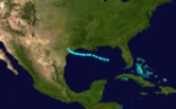
on August 4. It moved westward through the Caribbean Sea
, reaching hurricane strength on the 6th east of Jamaica
. It passed to the south of the island, and strengthened further to a Category 2 hurricane
, but a landfall on the Yucatán Peninsula
weakened it to a tropical storm. While moving across the Gulf, the storm intensified back to a hurricane on the 11th, followed by a period of rapid intensification to a 150 mph (240 km/h) hurricane with an estimated minimum pressure of 931 millibars. http://www.weather.unisys.com/hurricane/atlantic/1880/2/track.dat It made landfall near Brownsville, Texas
on the 13th, and dissipated rapidly over land on the 14th. It caused 30 deaths near the Yucatán Peninsula, and 5 deaths in Texas.
on August 15. It moved quickly through the islands, and reached hurricane strength on the 18th. It passed over Jamaica
the next day, followed by a Cuba
n landfall later that day. The circulation was disrupted over Cuba, and dissipated on the 20th over the Bahamas. It caused 30 deaths.
on the 29th. It passed over the peninsula, weakening to a tropical storm, but managed to become a hurricane prior to its second Florida landfall on the 31st. The storm continued northwestward, dissipating over Mississippi
on the September 1. It caused 68 deaths.
Tropical cyclone
A tropical cyclone is a storm system characterized by a large low-pressure center and numerous thunderstorms that produce strong winds and heavy rain. Tropical cyclones strengthen when water evaporated from the ocean is released as the saturated air rises, resulting in condensation of water vapor...
s form in the Atlantic basin
Atlantic Basin
The Atlantic Basin is the Atlantic Ocean.Atlantic Basin may also refer to:* Atlantic Basin Iron Works, an ironworks that operated in Brooklyn, New York, in the early to mid-20th century...
.
Tropical Storm One
This tropical storm lasted for a few days before making landfall on Texas, causing minimal damage. It then dissipated shortly after landfall.Hurricane Two
The second storm of the season formed over the northeastern Lesser AntillesLesser Antilles
The Lesser Antilles are a long, partly volcanic island arc in the Western Hemisphere. Most of its islands form the eastern boundary of the Caribbean Sea with the Atlantic Ocean, with the remainder located in the southern Caribbean just north of South America...
on August 4. It moved westward through the Caribbean Sea
Caribbean Sea
The Caribbean Sea is a sea of the Atlantic Ocean located in the tropics of the Western hemisphere. It is bounded by Mexico and Central America to the west and southwest, to the north by the Greater Antilles, and to the east by the Lesser Antilles....
, reaching hurricane strength on the 6th east of Jamaica
Jamaica
Jamaica is an island nation of the Greater Antilles, in length, up to in width and 10,990 square kilometres in area. It is situated in the Caribbean Sea, about south of Cuba, and west of Hispaniola, the island harbouring the nation-states Haiti and the Dominican Republic...
. It passed to the south of the island, and strengthened further to a Category 2 hurricane
Saffir-Simpson Hurricane Scale
The Saffir–Simpson Hurricane Scale , or the Saffir–Simpson Hurricane Wind Scale , classifies hurricanes — Western Hemisphere tropical cyclones that exceed the intensities of tropical depressions and tropical storms — into five categories distinguished by the intensities of their sustained winds...
, but a landfall on the Yucatán Peninsula
Yucatán Peninsula
The Yucatán Peninsula, in southeastern Mexico, separates the Caribbean Sea from the Gulf of Mexico, with the northern coastline on the Yucatán Channel...
weakened it to a tropical storm. While moving across the Gulf, the storm intensified back to a hurricane on the 11th, followed by a period of rapid intensification to a 150 mph (240 km/h) hurricane with an estimated minimum pressure of 931 millibars. http://www.weather.unisys.com/hurricane/atlantic/1880/2/track.dat It made landfall near Brownsville, Texas
Brownsville, Texas
Brownsville is a city in the southernmost tip of the state of Texas, in the United States. It is located on the northern bank of the Rio Grande, directly north and across the border from Matamoros, Tamaulipas, Mexico. Brownsville is the 16th largest city in the state of Texas with a population of...
on the 13th, and dissipated rapidly over land on the 14th. It caused 30 deaths near the Yucatán Peninsula, and 5 deaths in Texas.
Hurricane Three
The third storm of the season began its life just northeast of BarbadosBarbados
Barbados is an island country in the Lesser Antilles. It is in length and as much as in width, amounting to . It is situated in the western area of the North Atlantic and 100 kilometres east of the Windward Islands and the Caribbean Sea; therein, it is about east of the islands of Saint...
on August 15. It moved quickly through the islands, and reached hurricane strength on the 18th. It passed over Jamaica
Jamaica
Jamaica is an island nation of the Greater Antilles, in length, up to in width and 10,990 square kilometres in area. It is situated in the Caribbean Sea, about south of Cuba, and west of Hispaniola, the island harbouring the nation-states Haiti and the Dominican Republic...
the next day, followed by a Cuba
Cuba
The Republic of Cuba is an island nation in the Caribbean. The nation of Cuba consists of the main island of Cuba, the Isla de la Juventud, and several archipelagos. Havana is the largest city in Cuba and the country's capital. Santiago de Cuba is the second largest city...
n landfall later that day. The circulation was disrupted over Cuba, and dissipated on the 20th over the Bahamas. It caused 30 deaths.
Hurricane Four
The 4th storm of the year started over the central Atlantic on August 24. It moved steadily westward, reaching hurricane strength on the 26th. The next day it reached its peak of 100 mph (160 km/h) winds. The storm would retain that intensity until its landfall near St. Augustine, FloridaSt. Augustine, Florida
St. Augustine is a city in the northeast section of Florida and the county seat of St. Johns County, Florida, United States. Founded in 1565 by Spanish explorer and admiral Pedro Menéndez de Avilés, it is the oldest continuously occupied European-established city and port in the continental United...
on the 29th. It passed over the peninsula, weakening to a tropical storm, but managed to become a hurricane prior to its second Florida landfall on the 31st. The storm continued northwestward, dissipating over Mississippi
Mississippi
Mississippi is a U.S. state located in the Southern United States. Jackson is the state capital and largest city. The name of the state derives from the Mississippi River, which flows along its western boundary, whose name comes from the Ojibwe word misi-ziibi...
on the September 1. It caused 68 deaths.
Hurricane Five
This minimal hurricane came close to Bermuda and peaked out near 80 knots. The system then was picked up by a frontal system and recurved east-northeastward dissipating on September. .See also
- List of tropical cyclones
- List of Atlantic hurricane seasons