

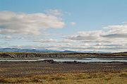
Þjórsá
Encyclopedia
Þjórsá is Iceland
's longest river
at 230 kilometers. It is in the southern region of the island.
 Þjórsá is a glacier river has its source on the glacier
Hofsjökull
. It flows out through narrow gorges in the highlands of Iceland
. Further downstream, another river, the Tungnaá
, flows into it (see also Háifoss
), before it enters the lowlands. There it passes the valley of Þjórsárdalur (Thjorsardalur) where the historical farm of Stöng is located. In the lowlands it flows along the eastern border of the Great Þjórsá lava
.
In the middle of the now rather wide river, there is a big island called Árnes, where in the past, was situated a Þing place. The administrative unit of Árnessýsla was named after it.
The hringvegur
(Road No.1) traverses the river via a bridge between Selfoss
and Hella. Some kilometers to the southwest the river flows into the Atlantic Ocean
.
Iceland
Iceland , described as the Republic of Iceland, is a Nordic and European island country in the North Atlantic Ocean, on the Mid-Atlantic Ridge. Iceland also refers to the main island of the country, which contains almost all the population and almost all the land area. The country has a population...
's longest river
River
A river is a natural watercourse, usually freshwater, flowing towards an ocean, a lake, a sea, or another river. In a few cases, a river simply flows into the ground or dries up completely before reaching another body of water. Small rivers may also be called by several other names, including...
at 230 kilometers. It is in the southern region of the island.
Glacier
A glacier is a large persistent body of ice that forms where the accumulation of snow exceeds its ablation over many years, often centuries. At least 0.1 km² in area and 50 m thick, but often much larger, a glacier slowly deforms and flows due to stresses induced by its weight...
Hofsjökull
Hofsjökull
Hofsjökull is the third largest glacier in Iceland after Vatnajökull and Langjökull and the largest active volcano in the country. It situates at the west of the Highlands of Iceland and north of the mountain range Kerlingarfjöll, between the two largest glaciers of Iceland. It covers an area of...
. It flows out through narrow gorges in the highlands of Iceland
Highlands of Iceland
The Highlands of Iceland cover most of the interior of Iceland. They are situated above 400–500 metres and are mostly an uninhabitable volcanic desert, because the water precipitating as rain or snow infiltrates so quickly into the ground that it is unavailable for plant growth, which results...
. Further downstream, another river, the Tungnaá
Tungnaá
The Tungnaá is a river in the southern highlands of Iceland. It flows from the western edge of Vatnajökull to the reservoir Sultartangalón, where it joins the Þjórsá. The river has been used extensively for hydroelectricity, with power stations at Vatnsfell, Sigalda, Hrauneyjafoss, and Sultartangi....
, flows into it (see also Háifoss
Háifoss
The waterfall Háifoss is situated near the volcano Hekla in the south of Iceland. The river Fossá, a tributary of Þjórsá, drops here from a height of 122 m...
), before it enters the lowlands. There it passes the valley of Þjórsárdalur (Thjorsardalur) where the historical farm of Stöng is located. In the lowlands it flows along the eastern border of the Great Þjórsá lava
Þjórsá lava
The Great Þjórsá Lava is the largest lava flow in Iceland both according to area and volume and the largest lava that is known to have erupted in a single eruption in the Holocene time. It belongs to a group of lavas known as the Tungná lavas. It was erupted in the Veiðivötn region, Central...
.
In the middle of the now rather wide river, there is a big island called Árnes, where in the past, was situated a Þing place. The administrative unit of Árnessýsla was named after it.
The hringvegur
Route 1 (Iceland)
Route 1 or the Ring Road is a main road in Iceland that runs around the island and connects all habitable parts of the country . The total length of the road is ....
(Road No.1) traverses the river via a bridge between Selfoss
Selfoss (town)
Selfoss is a town in southern Iceland on the banks of Ölfusá river.It is part, and seat, of the municipality Árborg. The Ring Road runs through the town on its way between Hveragerði and Hella...
and Hella. Some kilometers to the southwest the river flows into the Atlantic Ocean
Atlantic Ocean
The Atlantic Ocean is the second-largest of the world's oceanic divisions. With a total area of about , it covers approximately 20% of the Earth's surface and about 26% of its water surface area...
.
See also
- Rivers of Iceland