

Zurrieq
Encyclopedia
Żurrieq is one of the oldest towns in Malta
, and has a population of 12,000 inhabitants (Jul 2010). Żurrieq is situated in the South West of Malta. The first documentation about it being a parish dates back to 1436 dedicated to St. Catherine of Alexandria. The island of Filfla
is administratively a part of the town. The town strecthes from In Nigret to Hal far respectively in old times the town was a border with Zejtun. There were small villages part of Zurrieq including Qrendi, Birzebbuga, Hal Millieri, Hal Lew, Hal Manin, Bubaqra, Tal Baqqari, Hal Far, Hlantun, Hal Niklusi, Has Sejjih, Hal Qadim, Hal Arrig, Hal Gawhar, Hal Ghabdirzaq.
Żurrieq is part of the Fifth political District and votes for the local council every three years. The council is made up of nine members, one of them is the Mayor of the town. The present Mayor of Żurrieq is Silvio Izzi Savona. The parish Arch-priest being Rev. Charles Attard, helped by Rev. Raymond Cassar, Rev. Glenn Buhagiar, Rev. Carmel Busuttil and Rev. Nazzareno Tonna and Decon Luke Seguna.
We find the first historical reference of this village back in 1400. The villages of Hal Lew, Hal Millieri, Hal Manin, Bubaqra, Hal Far, Nigret and Qrendi used to make part of the village itself, until in 1618 the village of Qrendi became a village of its own while the others dissolved in a natural way with their area now making an integral part of the village perimeter.
Numerous ruins and remaining structures indicate the flow of the village through the time. These indicate the various settlements of peoples that inhabited the village area, from the Phoenicians to the Carathaginians, Greeks to the Romans. The remains found indicate these peoples as ancestors to the village, yet without excluding the possibility of other peoples, this village is rich in ruins and remains which in future may shed new light on its ancestors. Proof of this may be seen namely in remains such as the Punic Tower, Xarolla Catacombs, Cart Ruts at 'Tal-Bakkari', 'Tal-Hlantun Tower' and many others.
, and features a wide collection of ruins
and remains dating back to the Bronze
and Punic times, through the Roman, Knights and British eras. Structures dating back to the 15th and 16th century are scattered throughout the village.
The ruins have characteristics which identify the various settlements of peoples that inhabited the village area — from the Phoenicians to the Carthaginians, Greeks to the Romans. Examples of such remains include the Punic Tower, Xarolla Catacombs, Cart Ruts at Tal-Bakkari, and Tal-Hlantun Tower. The village has a very Big number of chapels and historical places such as the Xarolla Windmill
, Armery, Plazzo Ganbatist, Wardija Tower
, Bubaqra Tower and many other places of interest. Żurrieq is also well known for the Blue Grotto
that can be found found near Wied Babu.
 In the village of Zurrieq, one will find various archaeological remains dating back from various periods. One of these early findings was discovered in 1885, in the land known as ta' Danieri limits of tal-Hlewwa. In this location Phoenicia
n tombs were discovered containing the remains of three human skeletons and some pottery. On 1 August 1911, another tomb was found in the fields known as tal-Gharghariet limits of Nigret. In the area known as tal-Bakkari ruins were unearthed of a chapel, built on even older remains of what is thought to be a Roman temple.
One should mention that in the same site, in 1921, pottery dating back to either Punic or Roman times was found in an underground cistern
just under the ruins of the same chapel. Some relics were thought to be even of a former period, namely the bronze age. This would indicate that the same sight was used through the ages various peoples, though always for a spiritual purpose. One should also mention that a couple of metres from this sight, one will find the ruins of one of the towers which is referred to as Torri tal-Bakkari, which was constructed out of the same type and size of stone as those found in the chapel's ruins. On 6 September 1920, this tower was identified and compared with the ruins of two other towers partially standing and in a better preserved condition.
The other two towers are known as tat-Torrijiet and tal-Gawhar situated in the areas known as ta' Wilga and tal-Hlantun respectively. There are still contestations to their exact period, yet features may lead one to associate the towers to Bronze or Punic times. All three towers are of a perfect round shape and made of the same type of large stones, typically used long before Roman time, which is the period given by some. This may be determined from near investigation on the site of tal-Gawhar, were various features in the stone can be observed, such as altar shapes, holes to contain liquid like those used for sacrifice of blood, and other holes which could be used to tie up animals near the same altar .
On the 15th of March, 1930 a tomb was excavated containing human bones and roman pottery dating to the 7th century B.C.. On the 3rd of September, 1935 in a field known as 'Ta' Farrat', near the Xarolla Windmill, a tomb was found dating to the periods of the Carthaginians and Phoenicians, containing as well Roman pottery remains. On the 13th of June, 1930, a Roman tomb was uncovered in Hal Far in the area known as tal-Bakkari, another on the 4th of July, 1956, and another on the 5th of March, 1956, which were all excavated down in the rock and found containing Roman pottery of the third period.
On the 13th of July, 1938, Dun Gwann Farrugia asked the Museums authority to look into a building found in the gardens of the archpriest of Zurrieq. One will find reference to these remains in the book by J. Houel, Voyage Pittoresque de Sicile, Malte et Lipari. He claims that these remains date back to the Greek period. Unfortunately today only a small tower belonging to a larger building remains, known due to the actual dating of the same tower, as the Punic Tower. This tower is of great interest for the fact that punic remains on the island a scarce. The structure of the tower is made of stone cut in large perfectly square blocks and put together with great precision with the use of round dowels (mincotti) to hold the same blocks in place.
 According to Chev. Guze Galea 'in 1674, Grandmaster Nicolo Cottoner, built five windmills around Malta. One of these was the windmill built in Nigret, Zurrieq, known 'tal-Qaret'. After some time, in 1724, Grandmaster re-built another windmill next to it, known as ta' Marmara, which was the surname of the first person to work in the same windmill, Luret Marmara.
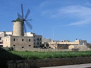
The windmill known as tas-Salib, was built by the Gafa' family, and knows its name to the village cross situated just to the south west of the same windmill. Another windmill is that known as tax-Xarolla, was built by Grandmaster Manoel de Vilhena, in 1724. In 1992, this was restored to its original working order is now the only functioning windmill in the islands of Malta and Gozo. This is a valuable witness of local culture and heritage still has parts of theoriginal mechanisms and can still grain the wheat. In the year 2000, this building was passed over to be administered by the Zurrieq Local Council and is intended to serve also as a cultural centre.
Feasts
in San Marino
. Angermünde
in Germany
.
Malta
Malta , officially known as the Republic of Malta , is a Southern European country consisting of an archipelago situated in the centre of the Mediterranean, south of Sicily, east of Tunisia and north of Libya, with Gibraltar to the west and Alexandria to the east.Malta covers just over in...
, and has a population of 12,000 inhabitants (Jul 2010). Żurrieq is situated in the South West of Malta. The first documentation about it being a parish dates back to 1436 dedicated to St. Catherine of Alexandria. The island of Filfla
Filfla
Filfla is a small, barren, uninhabited islet south of Malta, and is the most southerly point of the Maltese Archipelago. Filfoletta, a small rocky islet some 100 meters southwest of Filfla, has the southernmost point of Malta....
is administratively a part of the town. The town strecthes from In Nigret to Hal far respectively in old times the town was a border with Zejtun. There were small villages part of Zurrieq including Qrendi, Birzebbuga, Hal Millieri, Hal Lew, Hal Manin, Bubaqra, Tal Baqqari, Hal Far, Hlantun, Hal Niklusi, Has Sejjih, Hal Qadim, Hal Arrig, Hal Gawhar, Hal Ghabdirzaq.
Żurrieq is part of the Fifth political District and votes for the local council every three years. The council is made up of nine members, one of them is the Mayor of the town. The present Mayor of Żurrieq is Silvio Izzi Savona. The parish Arch-priest being Rev. Charles Attard, helped by Rev. Raymond Cassar, Rev. Glenn Buhagiar, Rev. Carmel Busuttil and Rev. Nazzareno Tonna and Decon Luke Seguna.
History
The Village of Zurrieq claims for a large area of the South Eastern part of the Island of Malta, in which village we find a wide collection going back to the Bronze and Punic times, through the Roman, Knights and British eras. The village in itself is to a large extent adorned with houses and buildings of historical value dating to the 15th and 16th centuries.We find the first historical reference of this village back in 1400. The villages of Hal Lew, Hal Millieri, Hal Manin, Bubaqra, Hal Far, Nigret and Qrendi used to make part of the village itself, until in 1618 the village of Qrendi became a village of its own while the others dissolved in a natural way with their area now making an integral part of the village perimeter.
Numerous ruins and remaining structures indicate the flow of the village through the time. These indicate the various settlements of peoples that inhabited the village area, from the Phoenicians to the Carathaginians, Greeks to the Romans. The remains found indicate these peoples as ancestors to the village, yet without excluding the possibility of other peoples, this village is rich in ruins and remains which in future may shed new light on its ancestors. Proof of this may be seen namely in remains such as the Punic Tower, Xarolla Catacombs, Cart Ruts at 'Tal-Bakkari', 'Tal-Hlantun Tower' and many others.
Ruins
Żurrieq is situated 6.8 km in a direct line from the City of VallettaValletta
Valletta is the capital of Malta, colloquially known as Il-Belt in Maltese. It is located in the central-eastern portion of the island of Malta, and the historical city has a population of 6,098. The name "Valletta" is traditionally reserved for the historic walled citadel that serves as Malta's...
, and features a wide collection of ruins
Ruins
Ruins are the remains of human-made architecture: structures that were once complete, as time went by, have fallen into a state of partial or complete disrepair, due to lack of maintenance or deliberate acts of destruction...
and remains dating back to the Bronze
Bronze Age
The Bronze Age is a period characterized by the use of copper and its alloy bronze as the chief hard materials in the manufacture of some implements and weapons. Chronologically, it stands between the Stone Age and Iron Age...
and Punic times, through the Roman, Knights and British eras. Structures dating back to the 15th and 16th century are scattered throughout the village.
The ruins have characteristics which identify the various settlements of peoples that inhabited the village area — from the Phoenicians to the Carthaginians, Greeks to the Romans. Examples of such remains include the Punic Tower, Xarolla Catacombs, Cart Ruts at Tal-Bakkari, and Tal-Hlantun Tower. The village has a very Big number of chapels and historical places such as the Xarolla Windmill
Xarolla Windmill
The Xarolla Windmill at Żurrieq, Malta is one of the windmills constructed by the Knights of Malta in the villages of Malta.In 1674 Grand Master Nicolas Cotoner built five windmills around Malta...
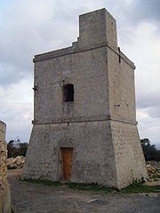
, Armery, Plazzo Ganbatist, Wardija Tower
Wardija Tower
The Wardija Tower is one of thirteen towers that Grand Master Martin de Redin of the Knights of Malta had built along the coasts of Malta. The tower is between Zurrieq and Hal Far; the nearest tower to it is the Hamrija Tower to the south-east. The Wardija Tower was constructed and finished by...
, Bubaqra Tower and many other places of interest. Żurrieq is also well known for the Blue Grotto
Blue Grotto (Malta)
The Blue Grotto is actually a number of sea caverns on the southern coast of Malta, west of the Wied iz-Żurrieq harbor near the village of Żurrieq. It is located right across the small uninhabited islet of Filfla....
that can be found found near Wied Babu.
Towers
Phoenicia
Phoenicia , was an ancient civilization in Canaan which covered most of the western, coastal part of the Fertile Crescent. Several major Phoenician cities were built on the coastline of the Mediterranean. It was an enterprising maritime trading culture that spread across the Mediterranean from 1550...
n tombs were discovered containing the remains of three human skeletons and some pottery. On 1 August 1911, another tomb was found in the fields known as tal-Gharghariet limits of Nigret. In the area known as tal-Bakkari ruins were unearthed of a chapel, built on even older remains of what is thought to be a Roman temple.
One should mention that in the same site, in 1921, pottery dating back to either Punic or Roman times was found in an underground cistern
Cistern
A cistern is a waterproof receptacle for holding liquids, usually water. Cisterns are often built to catch and store rainwater. Cisterns are distinguished from wells by their waterproof linings...
just under the ruins of the same chapel. Some relics were thought to be even of a former period, namely the bronze age. This would indicate that the same sight was used through the ages various peoples, though always for a spiritual purpose. One should also mention that a couple of metres from this sight, one will find the ruins of one of the towers which is referred to as Torri tal-Bakkari, which was constructed out of the same type and size of stone as those found in the chapel's ruins. On 6 September 1920, this tower was identified and compared with the ruins of two other towers partially standing and in a better preserved condition.
The other two towers are known as tat-Torrijiet and tal-Gawhar situated in the areas known as ta' Wilga and tal-Hlantun respectively. There are still contestations to their exact period, yet features may lead one to associate the towers to Bronze or Punic times. All three towers are of a perfect round shape and made of the same type of large stones, typically used long before Roman time, which is the period given by some. This may be determined from near investigation on the site of tal-Gawhar, were various features in the stone can be observed, such as altar shapes, holes to contain liquid like those used for sacrifice of blood, and other holes which could be used to tie up animals near the same altar .
Tombs
In August 1926, a tomb was discovered near the Xarolla Windmill, and from further investigations done on the 6th of the same month, it was determined that the tomb had already been touched and relics taken away, but there were still some pottery dating back to 200 A.D. Today these Paleo-Christian tombs are being excavated to their full extent after adjacent tombs were discovered in 1995, which now indicates a burial area of a larger size which could only belong to a large settlement in the area. In these tombs, one may find very interesting architectural features rarely found in similar tombs on the island. The size of the area containing the tombs indicate that in the area, there has always been a considerably large community, a settlement marking the area in time. There is the possibility that a Roman road passes through the area which would link the settlement in a both to northwest and the south of the island. The same road may date even prior to Roman settlement and there are indications that the Halfar Dolmen, the towers at tal-Bakkari and tat-Toirrijiet, the catacombs at tax-Xarolla, Hal Millieri and il-Mentna at Mqabba, are all on a perfect line.On the 15th of March, 1930 a tomb was excavated containing human bones and roman pottery dating to the 7th century B.C.. On the 3rd of September, 1935 in a field known as 'Ta' Farrat', near the Xarolla Windmill, a tomb was found dating to the periods of the Carthaginians and Phoenicians, containing as well Roman pottery remains. On the 13th of June, 1930, a Roman tomb was uncovered in Hal Far in the area known as tal-Bakkari, another on the 4th of July, 1956, and another on the 5th of March, 1956, which were all excavated down in the rock and found containing Roman pottery of the third period.
On the 13th of July, 1938, Dun Gwann Farrugia asked the Museums authority to look into a building found in the gardens of the archpriest of Zurrieq. One will find reference to these remains in the book by J. Houel, Voyage Pittoresque de Sicile, Malte et Lipari. He claims that these remains date back to the Greek period. Unfortunately today only a small tower belonging to a larger building remains, known due to the actual dating of the same tower, as the Punic Tower. This tower is of great interest for the fact that punic remains on the island a scarce. The structure of the tower is made of stone cut in large perfectly square blocks and put together with great precision with the use of round dowels (mincotti) to hold the same blocks in place.
Windmills
The windmill known as tas-Salib, was built by the Gafa' family, and knows its name to the village cross situated just to the south west of the same windmill. Another windmill is that known as tax-Xarolla, was built by Grandmaster Manoel de Vilhena, in 1724. In 1992, this was restored to its original working order is now the only functioning windmill in the islands of Malta and Gozo. This is a valuable witness of local culture and heritage still has parts of theoriginal mechanisms and can still grain the wheat. In the year 2000, this building was passed over to be administered by the Zurrieq Local Council and is intended to serve also as a cultural centre.
Churches and Chapels
- Parish Church dedicated to Saint Catherine Of Alexandria
- Bubaqra Chapel dedicated to the Assumption of Mary
- Nigret Chapel dedicated to the Immaculate conception of Mary
- Ħal-Millieri Chapels: Dedicated to the Annunciation and to Saint John
- Saint Leone's Chapel, found in the Parish Cemetery in Bubaqra
- Santa Agata's Chapel
- Saint James' Chapel
- Saint Bartholomew's Chapel
- Saint Andrew's Chapel
- Saint Luke's Chapel
Feasts
- Saint Catherine of Alexandria ( Main Feast )
- Our Lady of Mount Carmel ( Secondary Feast )
- Our Lady of the Rosary
- Saint Joseph
- Saint Rocco
- Santa Clementina
- Sacred Heart Of Jesus, celebrated in the Parish Church and also in Nigret.
- Corpus ChristiCorpus Christi (feast)Corpus Christi is a Latin Rite solemnity, now designated the solemnity of The Most Holy Body and Blood of Christ . It is also celebrated in some Anglican, Lutheran and Old Catholic Churches. Like Trinity Sunday and the Solemnity of Christ the King, it does not commemorate a particular event in...
- The Assumption of our Lady, Celebrated in Bubaqra
Streets showing Roman Catholic Faith
- Misrah Santa Marija(Saint Mary Square)
- Misraħ San Ġorg (Saint Georges Square)
- Misraħ il-Karmelitani (Carmelites Square)
- Triq Santa Katarina (St. Catherine's Street)
- Triq il-Benedittini (Benedictines Street)
- Triq il-Karmnu (Our Lady of Mount Carmel Street)
- Triq il-Kunċizzjoni (Immaculate Conception Street)
- Triq l-Isqof Alpheran (Bishop Alpheran Street)
- Triq San Bartilmew (St. Bartholomew Street)
- Triq San Luqa ( St. Luke Street)
- Triq San Bastjan (St. Sebastian Street)
- Triq San Ċiru (St. Ciros Street)
- Triq San David (St. David Street)
- Triq San Ġorġ (St. George Street)
- Triq San Ġwann (St. John Street)
- Triq San Iljun (St. Lion Street)
- Triq San Luqa ( St. Luke Street)
- Triq San Pawl (St. Paul Street)
- Triq San Mark (St. Mark Street)
- Triq San Lazzru (St. Lazrus)
- Triq Sant Antnin (St. Antony Street)
- Triq San Nikola (St. Nicholas Street)
- Triq San Pietru (St. Peter Street)
- Triq San Gwann (St. John Street)
- Triq San Mikiel (St. Michael Street)
- Triq San Martin (St. Martin Street)
- Triq San Iljun (St. Lion Street)
- Triq San Bastjan (St. Sebastian Street)
- Triq Sant Agata (St. Agatha Street)
- Triq Sant Porfilju
- Triq Santa Fawstina
- Triq Sant Andrija (St. Andrew Street)
- Triq Santa Katerina tal-Bakkari
- Triq Monsinjur Pietru Pawl Saydon
- Triq Monsinjur Pullicino
- Triq il-Kanonku Balzan
- Triq l-Immakulata ( Immaculate Conception Street)
- Trejqa l-Iben il-Ħali ( Prodigal Son Street)
- Sqaq il-Karmnu Nru.1 u Nru.2 (Our Lady of Mount Carmel Alley No.1 and No.2)
- Sqaq il-Kunċizzjoni (Immaculate Conception Alley)
- Sqaq San Anard (St. Leonard Alley)
- Sqaq San Bartolimew (St. Bartholomew Alley)
- Sqaq San Ċiru (St. Ciros Alley)
- Sqaq San Edwardu (St. Edward Alley)
- Sqaq San Ġakmu (St. James Alley)
- Sqaq San Ġużepp (St. Joseph Alley)
- Sqaq San Ġwann (St. John Alley)
- Sqaq San Martin (St. Martin Alley)
- Sqaq San Patrizju (St. Patrick's Alley)
- Żona Tal-Bambina (The Nativity of Our Lady Area)
- Triq Santa Katerina tal-Baqqari
Zones
- Bubaqra
- Nigret
- Xarolla
- Tal-Bebbux
- Tal Gawhar
- Ta' Xaqqa
- Ta' l-Għerien
- Taċ-Ċantar
- Tax-Xewki
- Tal-Ġibjun
- Tal-Bakkari
- Ta' Taħt iċ-Ċint
- Ħal-Millieri
- Ħal-Lew
- Ħal-Far
- Ħal-Manin
- Wied Ganu
- Wied Zurrieq
- Wied Babu
- Wied Ħallelin
- Wied Basasa
- Wied Żnuber
- Wied Fulija
- Għar Ħasan
- Hagar Qim
- Mnajdra
Sister cities
Żurrieq is twinned with: Borgo MaggioreBorgo Maggiore
Borgo Maggiore is one of the 9 communes or "castelli" of San Marino. It lies at the foot of Monte Titano and has a population of 5,992 , making it the second largest town of San Marino, after Dogana.-Geography:...
in San Marino
San Marino
San Marino, officially the Republic of San Marino , is a state situated on the Italian Peninsula on the eastern side of the Apennine Mountains. It is an enclave surrounded by Italy. Its size is just over with an estimated population of over 30,000. Its capital is the City of San Marino...
. Angermünde
Angermünde
Angermünde is a town in the district of Uckermark in the state of Brandenburg, Germany. It is located on the Mündesee, 43 miles northeast of Berlin on the Berlin–Szczecin railway...
in Germany
Germany
Germany , officially the Federal Republic of Germany , is a federal parliamentary republic in Europe. The country consists of 16 states while the capital and largest city is Berlin. Germany covers an area of 357,021 km2 and has a largely temperate seasonal climate...
.