

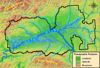
Yukon Flats
Encyclopedia
Wetland
A wetland is an area of land whose soil is saturated with water either permanently or seasonally. Wetlands are categorised by their characteristic vegetation, which is adapted to these unique soil conditions....
s, forest, bog, and low-lying ground centered on the confluence of the Yukon River
Yukon River
The Yukon River is a major watercourse of northwestern North America. The source of the river is located in British Columbia, Canada. The next portion lies in, and gives its name to Yukon Territory. The lower half of the river lies in the U.S. state of Alaska. The river is long and empties into...
, Porcupine River
Porcupine River
The Porcupine River is a river that runs through Alaska and the Yukon. Having its source in the Ogilvie Mountains north of Dawson City, Yukon, it flows north, veers to the southwest, goes through the community of Old Crow, Yukon, flowing into the Yukon River at Fort Yukon, Alaska...
, and Chandalar River
Chandalar River
The Chandalar River is a river in Alaska. Its peak flow recorded by the USGS was 62,800 cubic feet per second , on June 9, 1968....
in the central portion of the U.S. state of Alaska
Alaska
Alaska is the largest state in the United States by area. It is situated in the northwest extremity of the North American continent, with Canada to the east, the Arctic Ocean to the north, and the Pacific Ocean to the west and south, with Russia further west across the Bering Strait...
. The Yukon Flats are bordered in the north by the Brooks Range
Brooks Range
The Brooks Range is a mountain range in far northern North America. It stretches from west to east across northern Alaska and into Canada's Yukon Territory, a total distance of about 1100 km . The mountains top out at over 2,700 m . The range is believed to be approximately 126 million years old...
, in the south by the White Mountains
White Mountains (Alaska)
The White Mountains is a 115-km-long mountain range in the Yukon-Koyukuk Census Area of the U.S. state of Alaska. It lies between Beaver Creek and Preacher Creek, and was named by prospectors for its composition of white limestone. The range reaches a maximum elevation of 968 m...
, and cover an area of approximately 11000 square miles (28,490 km²). The Yukon Flats are a critical waterfowl breeding ground due to the large area of wetland provided by the estimated 40,000 small lakes and streams in the area. In recognition of this fact, the area is protected under the Yukon Flats National Wildlife Refuge
Yukon Flats National Wildlife Refuge
The Yukon Flats National Wildlife Refuge is a protected wetland area in the U.S. state of Alaska. It encompasses most of the Yukon Flats, a vast wetland area centered on the confluence of the Yukon River, Porcupine River, and Chandalar River...
.
The Yukon Flats straddle the Arctic Circle
Arctic Circle
The Arctic Circle is one of the five major circles of latitude that mark maps of the Earth. For Epoch 2011, it is the parallel of latitude that runs north of the Equator....
and have an extremely variable climate. Temperatures of 95 F (35 °C) are not uncommon in summer, while winter temperatures have been known to drop to -70 F (-57 °C).
Several thousand Alaska Natives and others live in the Yukon Flats area. Though most of the region's people are concentrated in the villages of Fort Yukon
Fort Yukon, Alaska
As of the census of 2000, there were 595 people, 225 households, and 137 families residing in the city. The population density was 85.0 people per square mile . There were 317 housing units at an average density of 45.3 per square mile...
, Venetie
Venetie, Alaska
Venetie , pronounced VEEN-ih-tye, is a census-designated place in Yukon-Koyukuk Census Area, Alaska, United States...
, Beaver
Beaver, Alaska
Beaver is a census-designated place in Yukon-Koyukuk Census Area, Alaska, United States. At the 2000 census the population was 84.-Geography:Beaver is located at ....
, Stevens Village
Stevens Village, Alaska
Stevens Village is a census-designated place in Yukon-Koyukuk Census Area, Alaska, United States. The population was 87 at the 2000 census.-Geography:...
, Chalkyitsik
Chalkyitsik, Alaska
Chalkyitsik is a census-designated place in Yukon-Koyukuk Census Area, Alaska, United States. At the 2000 census the population was 83.-Geography:Chalkyitsik is located at ....
, and smaller settlements, numerous hunting cabins and seasonal settlements also dot the region. The region also contains a large deposit of crude oil and natural gas
Natural gas
Natural gas is a naturally occurring gas mixture consisting primarily of methane, typically with 0–20% higher hydrocarbons . It is found associated with other hydrocarbon fuel, in coal beds, as methane clathrates, and is an important fuel source and a major feedstock for fertilizers.Most natural...
, a fact that has provoked conflict between drilling interests and those interested in protecting wildlife in the region.
In 2008, a land trade was proposed between Doyon, Limited
Doyon, Limited
Doyon, Limited is one of thirteen Alaska Native Regional Corporations created under the Alaska Native Claims Settlement Act of 1971 in settlement of aboriginal land claims. Doyon, Limited was incorporated in Alaska on June 26, 1972...
and the federal government. In exchange for several thousand acres of oil- and gas-rich land, Doyon offered to donate a somewhat larger parcel of land to the wildlife refuge. Debate about the land trade is ongoing and has not yet been resolved.