
Yucca Army Airfield
Encyclopedia
Yucca Army Airfield is a former military airfield located about 1 miles (1.6 km) west of Yucca
, in Mohave County, Arizona
. It is on the east side of Interstate 40, 25 miles (40.2 km) south of Kingman
. It is presently used as a testing facility by Chrysler LLC.
Yucca AAF was commanded by the 3019th Army Air Force Base Unit, as part of AAF Western Flying Training Command. It primarily was a Flexible Gunnery School, with the adjoining Yucca Air to Air Gunnery Range being located to the southwest of Yucca AAF. It consisted of a total of 550000 acres (2,225.8 km²), and the range had four runways. Bell P-39 & P-63 fighters were used as gunnery targets at Yucca Aux AAF. B-26 bombers were also used as target tugs at Yucca AAF.
In addition to the main base, the adjoining Yucca Air to Air Gunnery Range was located to the southwest of Yucca AAF.
It consisted of a total of 550,000 acres, and the range had 4 airfields. The civil Port Kingman Airport was also utilized as an auxiliary landing field:
Yucca AAF was closed and turned over to the Army Division Engineers on 23 December 1945. It declared surplus in 1946 and responsibility for it was given to the War Assets Administration.
As of 2002, the airfield itself was still operated by Ford as a private airfield, known as the Arizona Proving Ground Airport. Ford also continued to use some of the original military facilities, including the control tower, runways, taxiways, parking aprons, however all of the original military buildings (except for the control tower) had been removed. The Yucca airfield was evidently closed by Ford at some point between 2002-2006. In 2007 airfield was sold to Chrysler which now operates the Chrysler Proving Grounds
on this location. Given Chrysler's bankruptcy in 2009, it is unclear what the status of the facility is today.
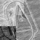
The USAAF technical site is now being used by buildings as part of the proving ground. No wartime structures are evident in aerial photos of the facility, nor is any of the wartime containment area. The wartime runways and taxiways are also nonexistent, the only remaining part being the concreted ramp area which is still used.
Yucca, Arizona
Yucca is an unincorporated community in Mohave County, Arizona, United States. Located along Interstate 40, it lies southwest of Kingman, just east of the southern section of the Black Mountains and west of the Hualapai and McCracken Mountains in the Sacramento Valley. Yucca has a ZIP Code of...
, in Mohave County, Arizona
Mohave County, Arizona
Mohave County is located in the northwestern corner of the U.S. state of Arizona. As of the 2010 census, its population was 200,186, an increase of 45,154 people since the 2000 census count of 155,032. The county seat is Kingman...
. It is on the east side of Interstate 40, 25 miles (40.2 km) south of Kingman
Kingman, Arizona
Kingman is located in a desert climate on the edge of the Mojave Desert, but its higher elevation and location between the Colorado Plateau and the Lower Colorado River Valley tempers summer high temperatures and contributes to winter cold and rare snowfall. Summer daytime highs reach above 90 °F ...
. It is presently used as a testing facility by Chrysler LLC.
Military use
In 1943-44, the US Army Air Forces acquired 2284 acres (9.2 km²) to build a satellite airfield for the use of Kingman AAF & its Gunnery School. Activated on 1 December 1941, the facility consisted of two 6,000' asphalt runways, taxiways, control tower, a total of 45 buildings, roads, a railroad spur, electrical utilities, water utilities, and a sewage disposal plant.Yucca AAF was commanded by the 3019th Army Air Force Base Unit, as part of AAF Western Flying Training Command. It primarily was a Flexible Gunnery School, with the adjoining Yucca Air to Air Gunnery Range being located to the southwest of Yucca AAF. It consisted of a total of 550000 acres (2,225.8 km²), and the range had four runways. Bell P-39 & P-63 fighters were used as gunnery targets at Yucca Aux AAF. B-26 bombers were also used as target tugs at Yucca AAF.
In addition to the main base, the adjoining Yucca Air to Air Gunnery Range was located to the southwest of Yucca AAF.
It consisted of a total of 550,000 acres, and the range had 4 airfields. The civil Port Kingman Airport was also utilized as an auxiliary landing field:
- Cyclopic Army Auxiliary Airfield #1 35°44′22"N 114°04′39"W
- Hackberry Army Auxiliary Airfield #3 35°26′02"N 113°47′59"W
- Topock Army Auxiliary Airfield #5 34°43′46"N 114°26′20"W
- Lake Havasu Auxiliary Army Airfield #6 34°27′36"N 114°21′36"W
- Signal Auxiliary Army Airfield #7 34°22′18"N 113°54′42"W
- Port Kingman Airport 35°13′21"N 114°01′09"W
Yucca AAF was closed and turned over to the Army Division Engineers on 23 December 1945. It declared surplus in 1946 and responsibility for it was given to the War Assets Administration.
Civil use
In 1954 the Ford Motor Company acquired the airport facility and began using the runways for automobile testing. Ford eventually built an extensive automotive proving ground surrounding the airfield.As of 2002, the airfield itself was still operated by Ford as a private airfield, known as the Arizona Proving Ground Airport. Ford also continued to use some of the original military facilities, including the control tower, runways, taxiways, parking aprons, however all of the original military buildings (except for the control tower) had been removed. The Yucca airfield was evidently closed by Ford at some point between 2002-2006. In 2007 airfield was sold to Chrysler which now operates the Chrysler Proving Grounds
Chrysler Proving Grounds
Chrysler LLC operates proving grounds around North America, for development and validation testing of new vehicles.-Arizona Proving Ground :Location:The Arizona Proving Ground is a vehicle test facility established in 1955 in Yucca, Arizona...
on this location. Given Chrysler's bankruptcy in 2009, it is unclear what the status of the facility is today.
The USAAF technical site is now being used by buildings as part of the proving ground. No wartime structures are evident in aerial photos of the facility, nor is any of the wartime containment area. The wartime runways and taxiways are also nonexistent, the only remaining part being the concreted ramp area which is still used.