

Yport
Encyclopedia
Yport is a commune in the Seine-Maritime
department in the Haute-Normandie
region
in northern France
. The residents are known as Yportais or Yportaises.
, on the coast of the English Channel
.
period, and later the Pays de Caux
was inhabited by the Calates
. During the Roman time, a road connecting Fécamp
to Étretat
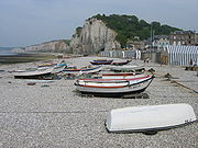
passed through the locality at Pitron Fund from where a junction towards the village existed. The current D940 follows the route of this Roman road. The Roman presence was discovered following various archaeological excavations but nothing proves that it was permanently inhabited. It may have been only a fishing site. Starting from the early Middle Ages the village was attached to Criquebeuf-en-Caux
, where the church, the cemetery and the school were located, several kilometres away from Yport. Only in the 19th century did the commune of Yport come into existence, primarily because of the construction of the church. Officially, the commune of Yport was created on January 1, 1843 and its first mayor was Jean-Baptiste Feuilloley. The 19th century marked the beginning of the rise of sea-fishing. Many people were attracted to the area by the work and the population reached 1800. The sea front evolved considerably during this period. As a working port, the sea front had fishing-smacks
, skiff
s, caïque
s and other vessels moored up to the bollard
s.
 During the 19th century, sea-bathing came into fashion, and Yport did not escape from it. In 1849 and 1884, the village was hit by cholera epidemics.
Later, in the 1960s, fishing disappeared, like everywhere on the Côte d'Albâtre
. The pace of life in the fishing village changed only very little. Yport is nowadays primarily a tourist town, with the casino, the beach and many quality restaurants. A large car-park has now replaced most of the fishing boats at the sea-front.
Seine-Maritime
Seine-Maritime is a French department in the Haute-Normandie region in northern France. It is situated on the northern coast of France, at the mouth of the Seine, and includes the cities of Rouen and Le Havre...
department in the Haute-Normandie
Haute-Normandie
Upper Normandy is one of the 27 regions of France. It was created in 1984 from two départements: Seine-Maritime and Eure, when Normandy was divided into Lower Normandy and Upper Normandy. This division continues to provoke controversy, and some continue to call for reuniting the two regions...
region
Régions of France
France is divided into 27 administrative regions , 22 of which are in Metropolitan France, and five of which are overseas. Corsica is a territorial collectivity , but is considered a region in mainstream usage, and is even shown as such on the INSEE website...
in northern France
France
The French Republic , The French Republic , The French Republic , (commonly known as France , is a unitary semi-presidential republic in Western Europe with several overseas territories and islands located on other continents and in the Indian, Pacific, and Atlantic oceans. Metropolitan France...
. The residents are known as Yportais or Yportaises.
Location
Yport is located on the D104 road, about 19 miles (30.6 km) north of Le HavreLe Havre
Le Havre is a city in the Seine-Maritime department of the Haute-Normandie region in France. It is situated in north-western France, on the right bank of the mouth of the river Seine on the English Channel. Le Havre is the most populous commune in the Haute-Normandie region, although the total...
, on the coast of the English Channel
English Channel
The English Channel , often referred to simply as the Channel, is an arm of the Atlantic Ocean that separates southern England from northern France, and joins the North Sea to the Atlantic. It is about long and varies in width from at its widest to in the Strait of Dover...
.
Demographics
History
The site was probably occupied during the neolithicNeolithic
The Neolithic Age, Era, or Period, or New Stone Age, was a period in the development of human technology, beginning about 9500 BC in some parts of the Middle East, and later in other parts of the world. It is traditionally considered as the last part of the Stone Age...
period, and later the Pays de Caux
Pays de Caux
The Pays de Caux is an area in Normandy occupying the greater part of the French département of Seine Maritime in Haute-Normandie. It is a chalk plateau to the north of the Seine Estuary and extending to the cliffs on the English Channel coast - its coastline is known as the Côte d'Albâtre...
was inhabited by the Calates
Calates
The Caletes or Caleti were a Gaulish tribe of present-day Normandy. They occupied a section of the coast, between the Sequana and the Phrudis rivers.Harfleur was their principal port....
. During the Roman time, a road connecting Fécamp
Fécamp
Fécamp is a commune in the Seine-Maritime department in the Haute-Normandie region in northern France.-Geography:Fécamp is situated in the valley of the river Valmont, at the heart of the Pays de Caux, on the Albaster Coast...
to Étretat
Étretat
Étretat is a commune in the Seine-Maritime department in the Haute-Normandie region in northern France. It is a tourist and farming town situated c. 32 km northeast of Le Havre, at the junction of the D940, D11 and D139 roads. It's located on the coast of the Pays de Caux area.-The...
passed through the locality at Pitron Fund from where a junction towards the village existed. The current D940 follows the route of this Roman road. The Roman presence was discovered following various archaeological excavations but nothing proves that it was permanently inhabited. It may have been only a fishing site. Starting from the early Middle Ages the village was attached to Criquebeuf-en-Caux
Criquebeuf-en-Caux
Criquebeuf-en-Caux is a commune in the Seine-Maritime department in the Haute-Normandie region in northern France.-Geography:A farming village situated in the Pays de Caux, some northeast of Le Havre, at the junction of the D211 and D940 roads...
, where the church, the cemetery and the school were located, several kilometres away from Yport. Only in the 19th century did the commune of Yport come into existence, primarily because of the construction of the church. Officially, the commune of Yport was created on January 1, 1843 and its first mayor was Jean-Baptiste Feuilloley. The 19th century marked the beginning of the rise of sea-fishing. Many people were attracted to the area by the work and the population reached 1800. The sea front evolved considerably during this period. As a working port, the sea front had fishing-smacks
Smack (ship)
A smack was a traditional fishing boat used off the coast of England and the Atlantic coast of America for most of the 19th century, and even in small numbers up to the Second World War. It was originally a cutter rigged sailing boat until about 1865, when the smacks became so large that cutter...
, skiff
Skiff
The term skiff is used for a number of essentially unrelated styles of small boat. The word is related to ship and has a complicated etymology: "skiff" comes from the Middle English skif, which derives from the Old French esquif, which in turn derives from the Old Italian schifo, which is itself of...
s, caïque
Caïque
A caïque , is the term for a traditional fishing boat usually found among the waters of the Ionian or Aegean Seas, and also a light skiff used on the Bosporus. It is traditionally a small wooden trading vessel, brightly painted and rigged for sail...
s and other vessels moored up to the bollard
Bollard
A bollard is a short vertical post. Originally it meant a post used on a ship or a quay, principally for mooring. The word now also describes a variety of structures to control or direct road traffic, such as posts arranged in a line to obstruct the passage of motor vehicles...
s.
Later, in the 1960s, fishing disappeared, like everywhere on the Côte d'Albâtre
Côte d'Albâtre
The Côte d'Albâtre is part of the French coast of the English Channel, corresponding to the coastline of Pays de Caux and forming almost all of the coastline of Seine-Maritime. Since 2009 it has been classified as a Natura 2000 site....
. The pace of life in the fishing village changed only very little. Yport is nowadays primarily a tourist town, with the casino, the beach and many quality restaurants. A large car-park has now replaced most of the fishing boats at the sea-front.
Heraldry
Tourism
- Cliffs
- Pebble beach
- St. Martin's church: building started in 1838, it was finished only in 1876 after many modifications.
- Casino
- Yport is the place where Guy de MaupassantGuy de MaupassantHenri René Albert Guy de Maupassant was a popular 19th-century French writer, considered one of the fathers of the modern short story and one of the form's finest exponents....
set his novel Une Vie
Festivals
- Torch-light parade on July 13.
- Festival of the sea and painting on August 15 (mass, blessing, holy procession). An exhibition of paintings, painters and sculptors in the streets and on the beach, auction sale at 5pm of the art created during the course of the day.