
Youngstown, Pennsylvania
Encyclopedia
Borough (Pennsylvania)
In the U.S. Commonwealth of Pennsylvania, a borough is a self-governing municipal entity that is usually smaller than a city. There are 958 boroughs in Pennsylvania. All municipalities in Pennsylvania are classified as either cities, boroughs, or townships...
in Westmoreland County
Westmoreland County, Pennsylvania
-Demographics:As of the census of 2000, there were 369,993 people, 149,813 households, and 104,569 families residing in the county. The population density was 361 people per square mile . There were 161,058 housing units at an average density of 157 per square mile...
, Pennsylvania
Pennsylvania
The Commonwealth of Pennsylvania is a U.S. state that is located in the Northeastern and Mid-Atlantic regions of the United States. The state borders Delaware and Maryland to the south, West Virginia to the southwest, Ohio to the west, New York and Ontario, Canada, to the north, and New Jersey to...
, United States
United States
The United States of America is a federal constitutional republic comprising fifty states and a federal district...
. Youngstown was incorporated on 2 April 1831. The population was 400 at the 2000 census.
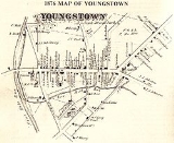
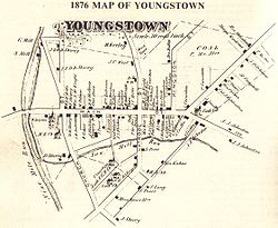
History
The town was named after Alexander Young, whose first lot was recorded November 25, 1815, in the Recorder's office of Westmoreland County. There was a dispute to the name of the town over if it should be called Martinsburg or Youngstown. The name Youngstown was settled upon after it was found that a town of Martinsburg already existed in the Commonwealth. James Keenan's recorded plan of land on April 3, 1816 recorded the town as Youngstown Borough. As the community grew, and more people settled in the area, the citizens formed a political government. The residents petitioned the legislature in Harrisburg to form Youngstown Borough out of their lands. Governor George WolfGeorge Wolf
George Wolf was the seventh Governor of Pennsylvania from 1829 to 1835.Wolf was born in Allen Township, Pennsylvania. He studied law, was admitted to the bar in 1799 and commenced practice in Easton, Pennsylvania. He served as postmaster of Easton in 1802 and 1803...
approved act No. 168 of 1830, on April 2, 1831. This act erected Youngstown, in the County of Westmoreland, into a Borough. Act No. 168 laid out the borough lines, and provided for elections of the burgess and other town officials, and stated the duties of the officials. As the town progressed, the residents felt themselves restricted by the Act of 1830 and petitioned Westmoreland County Court of Quarter Sessions to become subject to the Act of April 3, 1851. The Act of 1851 provided for more modern borough government than that permitted by the previous special act of legislature. The residents of the borough and their officers did not act quickly, since the petition to become subject to the Act of 1851 was not approved by Borough Council until July 25, 1905.
The opening of the Pennsylvania Government Land Office in the area in 1769, and the contract of the Pennsylvania Proprietaries with the Indians
Native Americans in the United States
Native Americans in the United States are the indigenous peoples in North America within the boundaries of the present-day continental United States, parts of Alaska, and the island state of Hawaii. They are composed of numerous, distinct tribes, states, and ethnic groups, many of which survive as...
opened up the Loyalhannah Valley for settlement for pioneers
American pioneer
American pioneers are any of the people in American history who migrated west to join in settling and developing new areas. The term especially refers to those who were going to settle any territory which had previously not been settled or developed by European or American society, although the...
, many of whom were of German
Germans
The Germans are a Germanic ethnic group native to Central Europe. The English term Germans has referred to the German-speaking population of the Holy Roman Empire since the Late Middle Ages....
and Scotch-Irish descent. Christopher Saxman in 1764, and Frederick Pershing in 1769 were the first recorded settlers in the area of present-day Youngstown. As a community and village grew, it was often called Martinsburg, after Martin West, another nearby land owner. Located along the Forbes road
Forbes Road
The Forbes Road was a historic military roadway in what was then British America, that was constructed in 1758 from Carlisle, Pennsylvania, to the French Fort Duquesne at the junction of the Allegheny and Monongahela rivers in what is now downtown Pittsburgh...
, a military road built under the command of Brigadier General John Forbes
John Forbes (General)
John Forbes was a British general in the French and Indian War. He is best known for leading the Forbes Expedition that captured the French outpost at Fort Duquesne and for naming the city of Pittsburgh, Pennsylvania after British Secretary of State William Pitt the Elder.-Early life:Forbes was...
in 1758, the town became an important rest stop along the east-west route that eventually stretched from Philadelphia to Pittsburgh. In 1794, Federal troops passed through and quartered at the town's Barrett Hotel on the way to quell the Whiskey Insurrection.
Until 1796, Youngstown, often referred to as Martinsburg, had been randomly settled, with various people making claims to the land. The first recorded transaction of land came on March 31, 1796, when Robery Dickey received a warrant from the Commonwealth of Pennsylvania for a 250 acres (1 km²) tract of land known as "Hermitage". John Mooore, a surveyor, pursuant to the warrant, issued a survey showing 251 acres (1 km²) of land. Robert Dickey conveyed Hermitage to Joseph Baldridge by deed dated February 18, 1797. The Commonwealth of Pennsylvania, through the offices of Governor Thomas Mifflin
Thomas Mifflin
Thomas Mifflin was an American merchant and politician from Philadelphia, Pennsylvania. He was a major general in the Continental Army during the American Revolution, a member of the Pennsylvania Provincial Assembly, a Continental Congressman from Pennsylvania, President of the Continental...
, issued a patent to Joseph Buldridge for the tract of land known as Hermitage on April 1, 1797.
Joseph Baldridge, another settler that built a mill in the area, was conveyed a deed for a 251 acres (1 km²) tract of land known as "Hermitage" in 1797. Lots on the land began to be sold in 1800. Alexander Young recorded the lots sold in 1815, and after a dispute between the names Martinsburg and Youngstown, the town received its name on April 3, 1816. General Arthur St. Clair
Arthur St. Clair
Arthur St. Clair was an American soldier and politician. Born in Scotland, he served in the British Army during the French and Indian War before settling in Pennsylvania, where he held local office...
, who had retired near Youngstown, died near his home there, “Hermitage”, in 1818. The Greensburg-Stoystown Turnpike was constructed along the old Forbes road in 1819, leading to more traffic and prosperity for the borough, which was now the largest town and served as a market place, with taverns, blacksmiths, wagon makers, harness shops and a variety of other merchants, and a post office for the region. The community continued to grow and on April 2, 1831, the citizens formally formed the borough as a political government. J. G. Karns was the first Burgess of Youngstown.
The Pennsylvania Railroad introduced train service through neighboring Latrobe
Latrobe, Pennsylvania
Latrobe is a city in Westmoreland County, Pennsylvania in the United States, approximately southeast of Pittsburgh.The city population was 7,634 as of the 2000 census . It is located near the Pennsylvania's scenic Chestnut Ridge. Latrobe was incorporated as a borough in 1854, and as a city in 1999...
in 1852, leading to a decline as merchants moved closer to the railway and the Greensburg-Stoystown Turnpike was less frequently used. As the automobile
Automobile
An automobile, autocar, motor car or car is a wheeled motor vehicle used for transporting passengers, which also carries its own engine or motor...
became popular, the turnpike became the Lincoln Highway
Lincoln Highway
The Lincoln Highway was the first road across the United States of America.Conceived and promoted by entrepreneur Carl G. Fisher, the Lincoln Highway spanned coast-to-coast from Times Square in New York City to Lincoln Park in San Francisco, originally through 13 states: New York, New Jersey,...
which brought traffic through Youngstown. U.S. Route 30
U.S. Route 30
U.S. Route 30 is an east–west main route of the system of United States Numbered Highways, with the highway traveling across the northern tier of the country. It is the third longest U.S. route, after U.S. Route 20 and U.S. Route 6. The western end of the highway is at Astoria, Oregon; the...
, constructed in the 1930s, bypassed Youngstown, leading it to become a quiet residential community. The Kingston House, a center for trade and commerce and hotel dating from 1800, was listed in the National Register of Historical Places on June 30, 1983.
Timeline Of Youngstown History
1758 Forbes Road was completed1769 Pennsylvania Government Land Office opened
1794 Whiskey insurrection - Troops were quartered at the Barrett Hotel
1799-1800 Youngstown Borough laid out
1819 Greensburgh-Stoystown Turnpike completed
1831 Youngstown incorporated by Act of Assembly
1852 Completion of the Pennsylvania Railroad through Latrobe
1861 Youngstown was an enlistment center for the Civil War
November 9, 1909 Council voted to enter into contract with West Penn Electric Company for placing and maintaining four arc lights on the main street of town.
October, 1916 Council ordered the borough weigh scales removed from Main Street.
March 6, 1918 Council adopted the contract of the State Highway Department for street paving.
August, 1818 - Arthur St. Clair, General in the Continental Army, member of the Continental Congress and the 9th President of the United States in Congress Assembled in 1798, the first Governor of the Northwest Territory, the first Commander of the U.S. Army, 1791–92) died in poverty on the Old State Road between Ligonier and Youngstown, when he was riding a wagon into town and probably had a stroke. He lived on top of the Laurel Ridge in a home and land given to him by his son Daniel. (There is a state marker at the site of his house, the house being torn down many years ago.) Arthur had run an inn where travelers stopped for food and supplies for their horses. His wife Phoebe was an invalid by this time and she died a week later. Both are buried under a Masonic monument in St. Clair park one block from the courthouse in Greensburg. His daughter, Louisa St. Clair Robb, and her six children were living with Arthur and Phoebe as were Elizabeth St. Clair Lawrence (a widow) and her children.
Arthur and his family left Hermitage around 1810, when the property was foreclosed by his creditors and all of his personal and real property was sold to satisfy debts. These debts had been incurred mostly when Arthur St. Clair signed his bond for Indian Treaties as well as other expenses in the Northwest Territory for which Congress authorized the funds, but never appropriated the money, leaving St. Clair without reimbursement. Also, debts due him from funds loaned to the government for the costs of the Revolution were never reimbursed, the government claimed that the statute of limitations had expired!
The old Hermitage house was torn down back in the 1950s and a Mrs. Mellon got word of it and had the parlor severed from the house and trucked to the new location of what would be the Ligonier Museum. The museum was built around the parlor. Mrs. Mellon authorized funds to purchase many of the things that were auctioned in the 1810 foreclosure sale and had them placed in the parlor and also in the collection of the museum. It is said that Arthur told his children to continue to petition the government for their inheritance, and in 1857 Congress appropriated $30,000 (which was a fraction of what was due) to the Arthur St. Clair Memorial, to be divided to the six branches of the family, with each branch receiving $5,000.
Geography
Youngstown is located at 40°16′51"N 79°21′56"W (40.280956, -79.365529).According to the United States Census Bureau
United States Census Bureau
The United States Census Bureau is the government agency that is responsible for the United States Census. It also gathers other national demographic and economic data...
, the borough has a total area of 0.1 square miles (0.3 km²), all of it land.
Adjacent to Youngstown lie Solomon's Temple Ridge and Sugarbush Ridge, sometimes known collectively as Youngstown Ridge
Youngstown Ridge
Youngstown Ridge is a sparsely populated mountain, adjacent to Youngstown, Pennsylvania in Westmoreland County. It is the collective name for two neighboring ridges, Sugarbrush Ridge and Solomon's Temple Ridge....
.
The famed Latrobe Country Club
Latrobe Country Club
Latrobe Country Club is a private golf club located near Latrobe, Pennsylvania. It is the home course of Arnold Palmer. The grounds are actually located in Unity Township in Westmoreland County, south of Latrobe, and nearer Youngstown.-History:...
, home course of golf
Golf
Golf is a precision club and ball sport, in which competing players use many types of clubs to hit balls into a series of holes on a golf course using the fewest number of strokes....
ing great Arnold Palmer
Arnold Palmer
Arnold Daniel Palmer is an American professional golfer, who is generally regarded as one of the greatest players in the history of men's professional golf. He has won numerous events on both the PGA Tour and Champions Tour, dating back to 1955...
, lies just outside the southwest limits of Youngstown.
Education
- New Castle School of Trades, http://www.ncstrades.com/home/. Technical and trade school in Youngstown, PA. The school offers training in building/construction trades, electrician training, heavy equipment operations, commercial truck driving, HVAC training, and industrial maintenance.
Demographics
As of the censusCensus
A census is the procedure of systematically acquiring and recording information about the members of a given population. It is a regularly occurring and official count of a particular population. The term is used mostly in connection with national population and housing censuses; other common...
of 2000, there were 400 people, 177 households, and 98 families residing in the borough. The population density
Population density
Population density is a measurement of population per unit area or unit volume. It is frequently applied to living organisms, and particularly to humans...
was 3,909.7 people per square mile (1,544.4/km²). There were 189 housing units at an average density of 1,847.3 per square mile (729.7/km²). The racial makeup of the borough was 99.50% White and 0.50% Native American. Hispanic or Latino of any race were 0.25% of the population.
There were 177 households out of which 24.3% had children under the age of 18 living with them, 40.7% were married couples
Marriage
Marriage is a social union or legal contract between people that creates kinship. It is an institution in which interpersonal relationships, usually intimate and sexual, are acknowledged in a variety of ways, depending on the culture or subculture in which it is found...
living together, 7.9% had a female householder with no husband present, and 44.6% were non-families. 37.3% of all households were made up of individuals and 14.7% had someone living alone who was 65 years of age or older. The average household size was 2.24 and the average family size was 3.04.
In the borough the population was spread out with 21.5% under the age of 18, 6.3% from 18 to 24, 30.0% from 25 to 44, 26.5% from 45 to 64, and 15.8% who were 65 years of age or older. The median age was 41 years. For every 100 females there were 85.2 males. For every 100 females age 18 and over, there were 88.0 males.
The median income for a household in the borough was $31,029, and the median income for a family was $34,167. Males had a median income of $26,964 versus $22,188 for females. The per capita income
Per capita income
Per capita income or income per person is a measure of mean income within an economic aggregate, such as a country or city. It is calculated by taking a measure of all sources of income in the aggregate and dividing it by the total population...
for the borough was $14,677. About 16.1% of families and 20.4% of the population were below the poverty line, including 12.5% of those under age 18 and 25.0% of those age 65 or over.