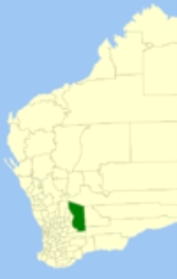
Yilgarn, Western Australia
Encyclopedia
The Shire of Yilgarn is a Local Government Area
in the Eastern Wheatbelt region of Western Australia
about 400 kilometres (248.5 mi) east of Perth
, the state capital. The Shire covers an area of 30720 square kilometres (11,861.1 sq mi) and its seat of government is the town of Southern Cross
. The main industries within the Shire are mining and farming.
As a result of local government reforms in Western Australia, the Shire of Yilgarn will merge with the Shire of Westonia in July 2012, forming the Shire of Westonia-Yilgarn.
Local Government Areas of Western Australia
The Australian state of Western Australia is divided into 141 local government areas...
in the Eastern Wheatbelt region of Western Australia
Western Australia
Western Australia is a state of Australia, occupying the entire western third of the Australian continent. It is bounded by the Indian Ocean to the north and west, the Great Australian Bight and Indian Ocean to the south, the Northern Territory to the north-east and South Australia to the south-east...
about 400 kilometres (248.5 mi) east of Perth
Perth, Western Australia
Perth is the capital and largest city of the Australian state of Western Australia and the fourth most populous city in Australia. The Perth metropolitan area has an estimated population of almost 1,700,000....
, the state capital. The Shire covers an area of 30720 square kilometres (11,861.1 sq mi) and its seat of government is the town of Southern Cross
Southern Cross, Western Australia
Southern Cross is a town in Western Australia, 371 kilometres east of Perth on the Great Eastern Highway. It was founded by gold prospectors in 1888, and gazetted in 1890. It is the major town and administrative centre of the Shire of Yilgarn...
. The main industries within the Shire are mining and farming.
History
In 1891, the Yilgarn Road Board was gazetted. In 1918, it merged with the Municipality of Southern Cross (gazetted 1892). On 1 July 1961, it became the Shire Council following changes to the Local Government Act.As a result of local government reforms in Western Australia, the Shire of Yilgarn will merge with the Shire of Westonia in July 2012, forming the Shire of Westonia-Yilgarn.
Wards
The shire has been divided into 3 wards.- Town Ward (4 councillors)
- North Ward (2 councillors)
- South Ward (3 councillors)
Towns and localities
Many of the following are ghost towns associated with short-lived mineral booms between the 1890s and the 1940s.- Southern CrossSouthern Cross, Western AustraliaSouthern Cross is a town in Western Australia, 371 kilometres east of Perth on the Great Eastern Highway. It was founded by gold prospectors in 1888, and gazetted in 1890. It is the major town and administrative centre of the Shire of Yilgarn...
- Baladjie
- BodallinBodallin, Western AustraliaBodallin is a town located around half way between Merredin and Southern Cross in Western Australia.The town takes its name from the railway siding of this name, established between 1894 and 1897. When gazetted in 1918 the town was spelt Boddalin...
- BullfinchBullfinch, Western AustraliaBullfinch is a small town in the Eastern Wheatbelt region of Western Australia.The town is based around the gold mining industry and was originally gazetted in 1910....
- Colreavy (also known as Golden Valley)
- Corinthia
- Dulyalbin
- Ennuin
- Garratt
- Ghooli
- Holleton
- KoolyanobbingKoolyanobbing, Western AustraliaKoolyanobbing is located 54 km NNE of the town of Southern Cross, Western Australia.Iron ore is mined here by a subsidiary of Cliffs Natural Resources of Cleveland, Ohio. Ore is railed to port at Esperance for export...
- Marvel LochMarvel Loch, Western AustraliaMarvel Loch is a small townsite of less than 100 people, some 401 km east of Perth, Western Australia. It is located 32 km south west of Southern Cross, along the Perth to Kalgoorlie Great Eastern Highway...
- Moorine RockMoorine Rock, Western AustraliaMoorine Rock is located in the eastern agricultural region of Western Australia, 347 km east of Perth and 22 km west south west of Southern Cross. It is located on the Great Eastern Highway and the railway line from Northam to Southern Cross. When the line was opened in 1895 a railway...
- Mount Hampton
- Mount Holland
- Mount JacksonMount Jackson, Western AustraliaMount Jackson is a hill in outback Western Australia located at . It is situated NNW of Koolyanobbing and NNE of Southern Cross. It is in the Shire of Yilgarn....
- Mount PalmerMount Palmer, Western AustraliaMount Palmer was a town in the Yilgarn shire in Western Australia. It was founded in 1934 after the discovery of gold in the area. The Mount Palmer Gold Mine operated from 1934 to 1944, when it closed due to labour shortages cause by World War II...
- NoongarNoongar, Western AustraliaNoongar is a small town located around half way between Merredin and Southern Cross along the Great Eastern Highway in Wheatbelt region of Western Australia....
- YellowdineYellowdine, Western AustraliaYellowdine is located 402 km east of Perth, Western Australia on the Great Eastern Highway. The townsite is in the goldfields region, situated in the Shire of Yilgarn.- History :...
- Yerbillon

