

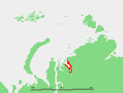
Yenisei Gulf
Encyclopedia
Yenisei River
Yenisei , also written as Yenisey, is the largest river system flowing to the Arctic Ocean. It is the central of the three great Siberian rivers that flow into the Arctic Ocean...
flows into the Kara Sea
Kara Sea
The Kara Sea is part of the Arctic Ocean north of Siberia. It is separated from the Barents Sea to the west by the Kara Strait and Novaya Zemlya, and the Laptev Sea to the east by the Severnaya Zemlya....
.
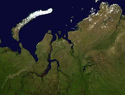
The Yenisei Gulf is formed by the river widening to an average of 50 km for up to 250 km in a roughly north-south direction, between a latitude of 70° 30' N in the area around Munguy settlement, north of Dudinka
Dudinka
Dudinka is a town and the administrative center of Taymyrsky Dolgano-Nenetsky District of Krasnoyarsk Krai, Russia. It was the administrative center of Taymyr Autonomous Okrug, which was merged into Krasnoyarsk Krai on January 1, 2007. It is a port in the lower reaches of the Yenisei River,...
. The whole region of the lower Yenisei is bleak and sparsely inhabited, and the settlements are built on permafrost ground. There is no vegetation except for moss
Moss
Mosses are small, soft plants that are typically 1–10 cm tall, though some species are much larger. They commonly grow close together in clumps or mats in damp or shady locations. They do not have flowers or seeds, and their simple leaves cover the thin wiry stems...
es, lichens and some grass.
The maximum depth of Yenisei Gulf is 208 feet (63.4 m).
The mouth of the Yenisei Gulf is roughly located at 72° 30’ N, in the area of Sibiryakov Island
Sibiryakov Island
Sibiryakov Island or Sibiryakow Island , also known as Kuz'kin Island , is an island of 800 square kilometres. Its length is 38 km and its maximum width 27 km...
, in the Kara Sea.
Islands
- The Yenisei has some flat, low-lying islands at its southern end, the Brekhovsky Islands (Бреховские острова) 70°30′N 82°45′E. They are located where the river flows into the estuary. This area is surrounded by lakes and swamps and it has many arms through which lesser rivers of the tundra flow across wetlands into it. Located:Asia ( Country):Russia:(Yenisei river )
- Further northwards the Yenisei widens and becomes a clear expanse. The water turns brackish at this point. There are three small islands located almost in the middle of the gulf, the Bolshoi Korsakovsky Islands (острова Большой Корсаковский ). The largest one is 4 km long and 1.2 km wide. 72°17′N 81°01′E. Burnyy Island is located right in the middle of the gulf. Chaishnyy is the closest to the shore.
- Krestovskiy Island or Krestovsky Island (Остров Крестовский) lies a further 9 km to the NNW, close to the eastern shore of the Yenisei Gulf. It is 7.5 km long and 1.8 km wide.72°24′N 80°47′E. This island was named after Russian writer Vsevolod Vladimirovich Krestovskiy (1840-1895).
Climate
The weather pattern in this desolate area is severe, with long and bitter winters and frequent blizzards and gales. The Yenisei estuary is frozen for about nine months in a year and even in summer it is never quite free of ice floes. During the winter the shipping lanes are kept open by icebreaker.Administration
The Yenisei Gulf and all its islands belong to the Krasnoyarsk KraiKrasnoyarsk Krai
Krasnoyarsk Krai is a federal subject of Russia . It is the second largest federal subject after the Sakha Republic, and Russia's largest krai, occupying an area of , which is 13% of the country's total territory. The administrative center of the krai is the city of Krasnoyarsk...
administrative division of the Russian Federation and is part of the Great Arctic State Nature Reserve
Great Arctic State Nature Reserve
The Great Arctic State Nature Reserve is a nature reserve in Krasnoyarsk Krai, Russia...
, the largest nature reserve of Russia.