

Yana Bay
Encyclopedia

Laptev Sea
The Laptev Sea is a marginal sea of the Arctic Ocean. It is located between the northern coast of Siberia, the Taimyr Peninsula, Severnaya Zemlya and the New Siberian Islands. Its northern boundary passes from the Arctic Cape to a point with co-ordinates of 79°N and 139°E, and ends at the Anisiy...
. It is located between Cape Buor-Khaya
Cape Buor-Khaya
The Buor-Khaya Cape, also known as Cape Buorkhaya, is a headland in the Laptev Sea. It is located between the Buor-Khaya Gulf on the west and the Yana Bay on the east. It is a conspicuous headland and has an 11 m high light on a framework tower....
on its western side and the Ebelyakh Bay
Ebelyakh Bay
The Ebelyakh Bay or Ebelyakhskaya Bay is a bay in the Laptev Sea. It is located east of the Yana Bay region and southwest of the Laptev Strait.The bay is 36 km in width and wide open to the northwest....
at its eastern end.
The Yana River
Yana River
The Yana River , is a river in Sakha in Russia, located between the Lena to the west and the Indigirka to the east.It is 872 km in length. The area of its basin is 238,000 km², whilst its annual discharge totals approximately . Most of this discharge occurs in May and June as the ice on the...
flows into the Yana Bay, forming a huge river delta
River delta
A delta is a landform that is formed at the mouth of a river where that river flows into an ocean, sea, estuary, lake, reservoir, flat arid area, or another river. Deltas are formed from the deposition of the sediment carried by the river as the flow leaves the mouth of the river...
(10,200 km²) that takes up much of the bay's coastline. The sea in this wide gulf is frozen for about nine months every year and is often clogged with ice floes.
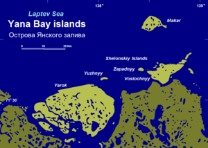
Yarok is a large flat island located east of the main mouths of the Yana. Other islands in the Yana Bay are Makar
Makar Island
Makar Island is an island in the Laptev Sea. It is located in the bay of the Yana river, about 30 km from the nearest coast to the south, and 21 km north of the Shelonsky Islands....
and the Shelonsky Islands
Shelonsky Islands
The Shelonsky Islands is an island group in the Laptev Sea. It is located in the coastal lowlands of the Yana Bay, east of the mouths of the Yana river.The Shelonsky Islands are marshy and flat....
. East of these islands lies a deep inlet stretching southwards known in Russian as Sellyakhskaya Guba.
Administratively the Yana Bay belongs to the Sakha Republic (Yakutia) of the Russian Federation.
History
In 1712 Yakov PermyakovYakov Permyakov
Yakov Permyakov was a Russian seafarer, explorer, merchant, and Cossack.In 1710, while sailing from the Lena River to the Kolyma River, Permyakov observed the silhouette of two unknown island groups in the sea...
and his companion Merkury Vagin
Merkury Vagin
Merkury Vagin was a Russian Arctic explorer.In 1712, together with Yakov Permyakov, Merkury Vagin explored the region of the eastern Laptev Sea coast, including Bolshoy Lyakhovsky Island, the southermost of the New Siberian Archipelago...
, the first recorded Russian explorers of the area, crossed the Yana Bay on dogsled from the mouth of the Yana River to Bolshoy Lyakhovsky over the ice in order to explore the then unknown island. Unfortunately Permyakov and Vagin were killed on the way back from their exploration by mutineering expedition members.
In 1892–1894 Baron Eduard von Toll, accompanied by expedition leader Alexander von Bunge, carried out geological surveys in the area on behalf of the Russian Imperial Academy of Sciences.