
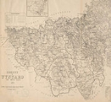
Wynyard County, New South Wales
Encyclopedia
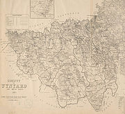
Cadastral divisions of New South Wales
Lands administrative divisions of New South Wales refers to the 141 counties within the Australian state of New South Wales, which are further subdivided into 7,459 parishes. There are also three Land Divisions, around 100 Land Districts, and several other types of districts as well as land boards...
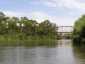
. It contains the city of Wagga Wagga. The Murrumbidgee River
Murrumbidgee River
The Murrumbidgee River is a major river in the state of New South Wales, Australia, and the Australian Capital Territory . A major tributary of the Murray River, the Murrumbidgee flows in a west-northwesterly direction from the foot of Peppercorn Hill in the Fiery Range of the Snowy Mountains,...
lies on the northern edge of the county, and the Tumut River
Tumut River
The Tumut River is a river in New South Wales, Australia.The Tumut River rises on the northern face of Mount Jagungal in the Snowy Mountains of southern New South Wales. It flows about 145km before joining the Murrumbidgee River, at Darbalara near the town of Gundagai...
on the eastern edge.
Wynyard County was named in honour of Major-General Robert Henry Wynyard (1802-1864).
ParishParishA parish is a territorial unit historically under the pastoral care and clerical jurisdiction of one parish priest, who might be assisted in his pastoral duties by a curate or curates - also priests but not the parish priest - from a more or less central parish church with its associated organization...
es within this county
A full list of parishes found within this county; their current LGA and mapping coordinates to the approximate centre of each location is as follows:| Parish | LGA | Coordinates |
|---|---|---|
| Adelong Adelong, New South Wales Adelong is a small town in the Riverina region of New South Wales, Australia and is a part of the Tumut Shire. The Adelong district has a population of about 1400, while Adelong itself has a population of 829 people.... |
Tumut Shire Council Tumut Shire Council Tumut Shire is a local government area in New South Wales, Australia. It includes the town of Tumut and the small towns of Gilmore, Adelong, Grahamstown, Gocup, Brungle, Talbingo, Wondalga, Batlow, Killimicat and Cabramurra.-References:... |
35°18′54"S 148°02′04"E |
| Bago | Tumbarumba Shire Council Tumbarumba Shire Council Tumbarumba Shire is a local government area in New South Wales, Australia in the foothills of the Snowy Mountains, on the upper reaches of the Murray River. It includes the town of Tumbarumba and the small towns of Rosewood, Tooma, Khancoban and Jingellic.... |
35°37′54"S 147°59′04"E |
| Bangus | Gundagai Shire Council Gundagai Shire Council Gundagai Shire is a local government area in the Riverina region of New South Wales, Australia, on the Hume Highway. Gundagai was declared a Municipality in 1889, and Adjungbilly Shire Council created in 1906 to administer the district... |
35°08′54"S 147°58′04"E |
| Batlow | Tumut Shire Council Tumut Shire Council Tumut Shire is a local government area in New South Wales, Australia. It includes the town of Tumut and the small towns of Gilmore, Adelong, Grahamstown, Gocup, Brungle, Talbingo, Wondalga, Batlow, Killimicat and Cabramurra.-References:... |
35°27′54"S 148°10′04"E |
| Belmore | City of Wagga Wagga City of Wagga Wagga The Wagga Wagga City Council was formed from the amalgamation of City of Wagga Wagga with Mitchell and Kyeamba Shires in 1981. 22 December 2009, Wagga Wagga City Council announced that Phil Pinyon would be appointed as the General Manager of the Wagga Wagga City Council after Lyn Russell, who... |
35°28′54"S 147°53′04"E |
| Blanch | City of Wagga Wagga City of Wagga Wagga The Wagga Wagga City Council was formed from the amalgamation of City of Wagga Wagga with Mitchell and Kyeamba Shires in 1981. 22 December 2009, Wagga Wagga City Council announced that Phil Pinyon would be appointed as the General Manager of the Wagga Wagga City Council after Lyn Russell, who... |
35°16′54"S 147°51′04"E |
| Book Book Book Book, New South Wales Book Book is a rural community in the central east part of the Riverina. It is situated about 12 kilometres north from Kyeamba and 15 kilometres south from Ladysmith.thumb|200px|left|Book Book Tennis Courts... |
City of Wagga Wagga City of Wagga Wagga The Wagga Wagga City Council was formed from the amalgamation of City of Wagga Wagga with Mitchell and Kyeamba Shires in 1981. 22 December 2009, Wagga Wagga City Council announced that Phil Pinyon would be appointed as the General Manager of the Wagga Wagga City Council after Lyn Russell, who... |
35°21′54"S 147°30′04"E |
| Borambula | City of Wagga Wagga City of Wagga Wagga The Wagga Wagga City Council was formed from the amalgamation of City of Wagga Wagga with Mitchell and Kyeamba Shires in 1981. 22 December 2009, Wagga Wagga City Council announced that Phil Pinyon would be appointed as the General Manager of the Wagga Wagga City Council after Lyn Russell, who... |
35°09′54"S 147°38′04"E |
| Bulalgee | Greater Hume Shire Council Greater Hume Shire Council Greater Hume Shire Council is a Local Government Area of New South Wales, Australia. The Council was formed in 2004 incorporating Culcairn Shire, the majority of Holbrook Shire and part of Hume Shire.... |
35°33′54"S 147°42′04"E |
| Califat | Tumut Shire Council Tumut Shire Council Tumut Shire is a local government area in New South Wales, Australia. It includes the town of Tumut and the small towns of Gilmore, Adelong, Grahamstown, Gocup, Brungle, Talbingo, Wondalga, Batlow, Killimicat and Cabramurra.-References:... |
35°14′54"S 148°05′04"E |
| Carabost Carabost, New South Wales Carabost is a foresting community in the south east part of the Riverina. It is situated about 16 kilometres north west from Rosewood and 22 kilometres south east from Kyeamba.thumb|200px|left|Facilities at Carabost... |
Greater Hume Shire Council Greater Hume Shire Council Greater Hume Shire Council is a Local Government Area of New South Wales, Australia. The Council was formed in 2004 incorporating Culcairn Shire, the majority of Holbrook Shire and part of Hume Shire.... |
35°36′54"S 147°41′04"E |
| Coreinbob | City of Wagga Wagga City of Wagga Wagga The Wagga Wagga City Council was formed from the amalgamation of City of Wagga Wagga with Mitchell and Kyeamba Shires in 1981. 22 December 2009, Wagga Wagga City Council announced that Phil Pinyon would be appointed as the General Manager of the Wagga Wagga City Council after Lyn Russell, who... |
35°14′54"S 147°39′04"E |
| Courabyra | Tumbarumba Shire Council Tumbarumba Shire Council Tumbarumba Shire is a local government area in New South Wales, Australia in the foothills of the Snowy Mountains, on the upper reaches of the Murray River. It includes the town of Tumbarumba and the small towns of Rosewood, Tooma, Khancoban and Jingellic.... |
35°39′54"S 148°01′04"E |
| Cunningdroo | City of Wagga Wagga City of Wagga Wagga The Wagga Wagga City Council was formed from the amalgamation of City of Wagga Wagga with Mitchell and Kyeamba Shires in 1981. 22 December 2009, Wagga Wagga City Council announced that Phil Pinyon would be appointed as the General Manager of the Wagga Wagga City Council after Lyn Russell, who... |
35°08′54"S 147°32′04"E |
| Dutzon | Tumut Shire Council Tumut Shire Council Tumut Shire is a local government area in New South Wales, Australia. It includes the town of Tumut and the small towns of Gilmore, Adelong, Grahamstown, Gocup, Brungle, Talbingo, Wondalga, Batlow, Killimicat and Cabramurra.-References:... |
35°21′54"S 147°54′04"E |
| Ellerslie | Tumut Shire Council Tumut Shire Council Tumut Shire is a local government area in New South Wales, Australia. It includes the town of Tumut and the small towns of Gilmore, Adelong, Grahamstown, Gocup, Brungle, Talbingo, Wondalga, Batlow, Killimicat and Cabramurra.-References:... |
35°14′54"S 147°56′04"E |
| Euadera | Tumut Shire Council Tumut Shire Council Tumut Shire is a local government area in New South Wales, Australia. It includes the town of Tumut and the small towns of Gilmore, Adelong, Grahamstown, Gocup, Brungle, Talbingo, Wondalga, Batlow, Killimicat and Cabramurra.-References:... |
35°15′54"S 148°00′04"E |
| Gadara | Tumut Shire Council Tumut Shire Council Tumut Shire is a local government area in New South Wales, Australia. It includes the town of Tumut and the small towns of Gilmore, Adelong, Grahamstown, Gocup, Brungle, Talbingo, Wondalga, Batlow, Killimicat and Cabramurra.-References:... |
35°18′54"S 148°07′04"E |
| Gilmore | Tumut Shire Council Tumut Shire Council Tumut Shire is a local government area in New South Wales, Australia. It includes the town of Tumut and the small towns of Gilmore, Adelong, Grahamstown, Gocup, Brungle, Talbingo, Wondalga, Batlow, Killimicat and Cabramurra.-References:... |
35°22′54"S 148°09′04"E |
| Goldspink | Tumbarumba Shire Council Tumbarumba Shire Council Tumbarumba Shire is a local government area in New South Wales, Australia in the foothills of the Snowy Mountains, on the upper reaches of the Murray River. It includes the town of Tumbarumba and the small towns of Rosewood, Tooma, Khancoban and Jingellic.... |
35°37′54"S 147°55′04"E |
| Gregadoo Gregadoo, New South Wales Gregadoo is a suburb of Wagga Wagga situated about 6 km South South-East of Lake Albert, New South Wales. It is situated by road, about 9 kilometres south east from Wagga Wagga.... |
City of Wagga Wagga City of Wagga Wagga The Wagga Wagga City Council was formed from the amalgamation of City of Wagga Wagga with Mitchell and Kyeamba Shires in 1981. 22 December 2009, Wagga Wagga City Council announced that Phil Pinyon would be appointed as the General Manager of the Wagga Wagga City Council after Lyn Russell, who... |
35°14′54"S 147°27′04"E |
| Gumly Gumly Gumly Gumly, New South Wales Gumly Gumly is a suburb of the city of Wagga Wagga, New South Wales, Australia and is located approximately 8 km east of the CBD on the Sturt Highway.... |
City of Wagga Wagga City of Wagga Wagga The Wagga Wagga City Council was formed from the amalgamation of City of Wagga Wagga with Mitchell and Kyeamba Shires in 1981. 22 December 2009, Wagga Wagga City Council announced that Phil Pinyon would be appointed as the General Manager of the Wagga Wagga City Council after Lyn Russell, who... |
35°09′54"S 147°28′04"E |
| Hillas | Tumut Shire Council Tumut Shire Council Tumut Shire is a local government area in New South Wales, Australia. It includes the town of Tumut and the small towns of Gilmore, Adelong, Grahamstown, Gocup, Brungle, Talbingo, Wondalga, Batlow, Killimicat and Cabramurra.-References:... |
35°29′54"S 148°00′04"E |
| Hindmarsh | Tumut Shire Council Tumut Shire Council Tumut Shire is a local government area in New South Wales, Australia. It includes the town of Tumut and the small towns of Gilmore, Adelong, Grahamstown, Gocup, Brungle, Talbingo, Wondalga, Batlow, Killimicat and Cabramurra.-References:... |
35°27′54"S 148°06′04"E |
| Humula Humula, New South Wales Humula is a small country town between Tarcutta and Tumbarumba in New South Wales, Australia. Humula Station, which is just outside the town, is one of Australia's most historic farming and grazing properties. Humula was once named "American Yards" or "American Fields" during the gold rush, where... |
City of Wagga Wagga City of Wagga Wagga The Wagga Wagga City Council was formed from the amalgamation of City of Wagga Wagga with Mitchell and Kyeamba Shires in 1981. 22 December 2009, Wagga Wagga City Council announced that Phil Pinyon would be appointed as the General Manager of the Wagga Wagga City Council after Lyn Russell, who... |
35°28′54"S 147°46′04"E |
| Keajura | City of Wagga Wagga City of Wagga Wagga The Wagga Wagga City Council was formed from the amalgamation of City of Wagga Wagga with Mitchell and Kyeamba Shires in 1981. 22 December 2009, Wagga Wagga City Council announced that Phil Pinyon would be appointed as the General Manager of the Wagga Wagga City Council after Lyn Russell, who... |
35°19′54"S 147°39′04"E |
| Kilgowla | City of Wagga Wagga City of Wagga Wagga The Wagga Wagga City Council was formed from the amalgamation of City of Wagga Wagga with Mitchell and Kyeamba Shires in 1981. 22 December 2009, Wagga Wagga City Council announced that Phil Pinyon would be appointed as the General Manager of the Wagga Wagga City Council after Lyn Russell, who... |
35°23′54"S 147°38′04"E |
| Kyeamba Kyeamba, New South Wales Kyeamba is a farming community in the central east part of the Riverina and situated about 16 kilometres north west from Humula and 23 kilometres north east from Tarcutta. At the 2006 census, Kyeamba had a population of 212... |
City of Wagga Wagga City of Wagga Wagga The Wagga Wagga City Council was formed from the amalgamation of City of Wagga Wagga with Mitchell and Kyeamba Shires in 1981. 22 December 2009, Wagga Wagga City Council announced that Phil Pinyon would be appointed as the General Manager of the Wagga Wagga City Council after Lyn Russell, who... |
35°23′54"S 147°29′04"E |
| Livingstone | City of Wagga Wagga City of Wagga Wagga The Wagga Wagga City Council was formed from the amalgamation of City of Wagga Wagga with Mitchell and Kyeamba Shires in 1981. 22 December 2009, Wagga Wagga City Council announced that Phil Pinyon would be appointed as the General Manager of the Wagga Wagga City Council after Lyn Russell, who... |
35°22′54"S 147°26′04"E |
| Mate | City of Wagga Wagga City of Wagga Wagga The Wagga Wagga City Council was formed from the amalgamation of City of Wagga Wagga with Mitchell and Kyeamba Shires in 1981. 22 December 2009, Wagga Wagga City Council announced that Phil Pinyon would be appointed as the General Manager of the Wagga Wagga City Council after Lyn Russell, who... |
35°26′54"S 147°51′04"E |
| Minjary | Tumut Shire Council Tumut Shire Council Tumut Shire is a local government area in New South Wales, Australia. It includes the town of Tumut and the small towns of Gilmore, Adelong, Grahamstown, Gocup, Brungle, Talbingo, Wondalga, Batlow, Killimicat and Cabramurra.-References:... |
35°15′54"S 148°10′04"E |
| Mundarlo Mundarlo, New South Wales Mundarlo is a farming community in the central east part of the Riverina and situated about 13 kilometres south east from Wantabadgery and 18 kilometres north west from Tumblong... |
Gundagai Shire Council Gundagai Shire Council Gundagai Shire is a local government area in the Riverina region of New South Wales, Australia, on the Hume Highway. Gundagai was declared a Municipality in 1889, and Adjungbilly Shire Council created in 1906 to administer the district... |
35°06′54"S 147°51′04"E |
| Murraguldrie | City of Wagga Wagga City of Wagga Wagga The Wagga Wagga City Council was formed from the amalgamation of City of Wagga Wagga with Mitchell and Kyeamba Shires in 1981. 22 December 2009, Wagga Wagga City Council announced that Phil Pinyon would be appointed as the General Manager of the Wagga Wagga City Council after Lyn Russell, who... |
35°27′54"S 147°36′04"E |
| Nacki Nacki | Tumut Shire Council Tumut Shire Council Tumut Shire is a local government area in New South Wales, Australia. It includes the town of Tumut and the small towns of Gilmore, Adelong, Grahamstown, Gocup, Brungle, Talbingo, Wondalga, Batlow, Killimicat and Cabramurra.-References:... |
35°21′54"S 147°58′04"E |
| Oberne Oberne, New South Wales Oberne is a rural community in the eastern part of the Riverina. It is situated about 10 kilometres north east from Humula and 18 kilometres south from Tarcutta.Oberne Creek Post Office opened on 1 April 1916 and closed in 1968.... |
City of Wagga Wagga City of Wagga Wagga The Wagga Wagga City Council was formed from the amalgamation of City of Wagga Wagga with Mitchell and Kyeamba Shires in 1981. 22 December 2009, Wagga Wagga City Council announced that Phil Pinyon would be appointed as the General Manager of the Wagga Wagga City Council after Lyn Russell, who... |
35°20′54"S 147°48′04"E |
| Rowan | City of Wagga Wagga City of Wagga Wagga The Wagga Wagga City Council was formed from the amalgamation of City of Wagga Wagga with Mitchell and Kyeamba Shires in 1981. 22 December 2009, Wagga Wagga City Council announced that Phil Pinyon would be appointed as the General Manager of the Wagga Wagga City Council after Lyn Russell, who... |
35°14′54"S 147°22′04"E |
| Selwyn | Tumut Shire Council Tumut Shire Council Tumut Shire is a local government area in New South Wales, Australia. It includes the town of Tumut and the small towns of Gilmore, Adelong, Grahamstown, Gocup, Brungle, Talbingo, Wondalga, Batlow, Killimicat and Cabramurra.-References:... |
35°33′54"S 148°09′04"E |
| South Gundagai | Gundagai Shire Council Gundagai Shire Council Gundagai Shire is a local government area in the Riverina region of New South Wales, Australia, on the Hume Highway. Gundagai was declared a Municipality in 1889, and Adjungbilly Shire Council created in 1906 to administer the district... |
35°03′54"S 148°09′04"E |
| South Wagga Wagga | City of Wagga Wagga City of Wagga Wagga The Wagga Wagga City Council was formed from the amalgamation of City of Wagga Wagga with Mitchell and Kyeamba Shires in 1981. 22 December 2009, Wagga Wagga City Council announced that Phil Pinyon would be appointed as the General Manager of the Wagga Wagga City Council after Lyn Russell, who... |
35°07′54"S 147°21′04"E |
| Tarcutta Tarcutta, New South Wales Tarcutta is a small town located 438 km south-west of Sydney, three kilometres east of the Hume Highway, in New South Wales, Australia. It was proclaimed as a village on 28 October 1890... |
Gundagai Shire Council Gundagai Shire Council Gundagai Shire is a local government area in the Riverina region of New South Wales, Australia, on the Hume Highway. Gundagai was declared a Municipality in 1889, and Adjungbilly Shire Council created in 1906 to administer the district... |
35°10′54"S 147°45′04"E |
| Tarrabandra | Gundagai Shire Council Gundagai Shire Council Gundagai Shire is a local government area in the Riverina region of New South Wales, Australia, on the Hume Highway. Gundagai was declared a Municipality in 1889, and Adjungbilly Shire Council created in 1906 to administer the district... |
35°08′54"S 148°10′04"E |
| Tumut | Tumut Shire Council Tumut Shire Council Tumut Shire is a local government area in New South Wales, Australia. It includes the town of Tumut and the small towns of Gilmore, Adelong, Grahamstown, Gocup, Brungle, Talbingo, Wondalga, Batlow, Killimicat and Cabramurra.-References:... |
35°16′54"S 148°10′04"E |
| Tywong | City of Wagga Wagga City of Wagga Wagga The Wagga Wagga City Council was formed from the amalgamation of City of Wagga Wagga with Mitchell and Kyeamba Shires in 1981. 22 December 2009, Wagga Wagga City Council announced that Phil Pinyon would be appointed as the General Manager of the Wagga Wagga City Council after Lyn Russell, who... |
35°14′54"S 147°33′04"E |
| Umbango | City of Wagga Wagga City of Wagga Wagga The Wagga Wagga City Council was formed from the amalgamation of City of Wagga Wagga with Mitchell and Kyeamba Shires in 1981. 22 December 2009, Wagga Wagga City Council announced that Phil Pinyon would be appointed as the General Manager of the Wagga Wagga City Council after Lyn Russell, who... |
35°26′54"S 147°46′04"E |
| Umutbee | City of Wagga Wagga City of Wagga Wagga The Wagga Wagga City Council was formed from the amalgamation of City of Wagga Wagga with Mitchell and Kyeamba Shires in 1981. 22 December 2009, Wagga Wagga City Council announced that Phil Pinyon would be appointed as the General Manager of the Wagga Wagga City Council after Lyn Russell, who... |
35°14′54"S 147°45′04"E |
| Wallace | Tumut Shire Council Tumut Shire Council Tumut Shire is a local government area in New South Wales, Australia. It includes the town of Tumut and the small towns of Gilmore, Adelong, Grahamstown, Gocup, Brungle, Talbingo, Wondalga, Batlow, Killimicat and Cabramurra.-References:... |
35°17′54"S 147°54′04"E |
| Wereboldera | Tumut Shire Council Tumut Shire Council Tumut Shire is a local government area in New South Wales, Australia. It includes the town of Tumut and the small towns of Gilmore, Adelong, Grahamstown, Gocup, Brungle, Talbingo, Wondalga, Batlow, Killimicat and Cabramurra.-References:... |
35°22′54"S 148°13′04"E |
| Willie Ploma | Gundagai Shire Council Gundagai Shire Council Gundagai Shire is a local government area in the Riverina region of New South Wales, Australia, on the Hume Highway. Gundagai was declared a Municipality in 1889, and Adjungbilly Shire Council created in 1906 to administer the district... |
35°08′54"S 148°03′04"E |
| Wondalga Wondalga, New South Wales Wondalga is a rural community in the central east part of the Riverina and situated about 14 kilometres north of Batlow and 16 km south of Adelong.Middle Adelong Post Office opened on 1 August 1875 , was renamed Wondalga in 1908 and closed in 1971.... |
Tumut Shire Council Tumut Shire Council Tumut Shire is a local government area in New South Wales, Australia. It includes the town of Tumut and the small towns of Gilmore, Adelong, Grahamstown, Gocup, Brungle, Talbingo, Wondalga, Batlow, Killimicat and Cabramurra.-References:... |
35°23′54"S 148°05′04"E |
| Wood | Greater Hume Shire Council Greater Hume Shire Council Greater Hume Shire Council is a Local Government Area of New South Wales, Australia. The Council was formed in 2004 incorporating Culcairn Shire, the majority of Holbrook Shire and part of Hume Shire.... |
35°37′54"S 147°50′04"E |
| Woomahrigong | City of Wagga Wagga City of Wagga Wagga The Wagga Wagga City Council was formed from the amalgamation of City of Wagga Wagga with Mitchell and Kyeamba Shires in 1981. 22 December 2009, Wagga Wagga City Council announced that Phil Pinyon would be appointed as the General Manager of the Wagga Wagga City Council after Lyn Russell, who... |
35°16′54"S 147°25′04"E |
| Yabtree | Gundagai Shire Council Gundagai Shire Council Gundagai Shire is a local government area in the Riverina region of New South Wales, Australia, on the Hume Highway. Gundagai was declared a Municipality in 1889, and Adjungbilly Shire Council created in 1906 to administer the district... |
35°06′54"S 147°45′04"E |
| Yaven | Gundagai Shire Council Gundagai Shire Council Gundagai Shire is a local government area in the Riverina region of New South Wales, Australia, on the Hume Highway. Gundagai was declared a Municipality in 1889, and Adjungbilly Shire Council created in 1906 to administer the district... |
35°11′54"S 147°51′04"E |