
Winifred, Montana
Encyclopedia
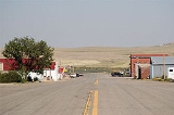
Winifred is a town in north-central Fergus County
, Montana
, United States
. The population was 156 at the 2000 census. Winifred was founded in 1913 as the terminus of a newly-built branch line of the Chicago, Milwaukee, St. Paul and Pacific Railroad
("the Milwaukee Road"). It is popularly believed to have been named after one of the railroad owner's two daughters (the other being Christina, another small town about 15 miles away).
According to the United States Census Bureau
, the town has a total area of 0.5 square miles (1.3 km²), all of it land.
of 2000, there were 156 people, 69 households, and 38 families residing in the town. The population density
was 305.0 people per square mile (118.1/km²). There were 85 housing units at an average density of 166.2 per square mile (64.4/km²). The racial makeup of the town was 96.79% White, 1.28% Native American, 0.64% from other races
, and 1.28% from two or more races. Hispanic or Latino of any race were 1.92% of the population.
There were 69 households out of which 24.6% had children under the age of 18 living with them, 44.9% were married couples
living together, 7.2% had a female householder with no husband present, and 43.5% were non-families. 39.1% of all households were made up of individuals and 13.0% had someone living alone who was 65 years of age or older. The average household size was 2.26 and the average family size was 3.13.
In the town the population was spread out with 23.1% under the age of 18, 5.8% from 18 to 24, 27.6% from 25 to 44, 28.2% from 45 to 64, and 15.4% who were 65 years of age or older. The median age was 41 years. For every 100 females there were 116.7 males. For every 100 females age 18 and over, there were 110.5 males.
The median income for a household in the town was $25,000, and the median income for a family was $33,393. Males had a median income of $17,321 versus $18,750 for females. The per capita income
for the town was $12,600. About 17.0% of families and 23.9% of the population were below the poverty line, including 42.9% of those under the age of eighteen and 16.0% of those sixty five or over.
Fergus County, Montana
-National protected areas:* Charles M. Russell National Wildlife Refuge * Lewis and Clark National Forest * Upper Missouri River Breaks National Monument -Demographics:...
, Montana
Montana
Montana is a state in the Western United States. The western third of Montana contains numerous mountain ranges. Smaller, "island ranges" are found in the central third of the state, for a total of 77 named ranges of the Rocky Mountains. This geographical fact is reflected in the state's name,...
, United States
United States
The United States of America is a federal constitutional republic comprising fifty states and a federal district...
. The population was 156 at the 2000 census. Winifred was founded in 1913 as the terminus of a newly-built branch line of the Chicago, Milwaukee, St. Paul and Pacific Railroad
Chicago, Milwaukee, St. Paul and Pacific Railroad
The Milwaukee Road, officially the Chicago, Milwaukee, St. Paul and Pacific Railroad , was a Class I railroad that operated in the Midwest and Northwest of the United States from 1847 until its merger into the Soo Line Railroad on January 1, 1986. The company went through several official names...
("the Milwaukee Road"). It is popularly believed to have been named after one of the railroad owner's two daughters (the other being Christina, another small town about 15 miles away).
Geography
Winifred is located at 47°33′35"N 109°22′38"W (47.559818, -109.377108).According to the United States Census Bureau
United States Census Bureau
The United States Census Bureau is the government agency that is responsible for the United States Census. It also gathers other national demographic and economic data...
, the town has a total area of 0.5 square miles (1.3 km²), all of it land.
Demographics
As of the censusCensus
A census is the procedure of systematically acquiring and recording information about the members of a given population. It is a regularly occurring and official count of a particular population. The term is used mostly in connection with national population and housing censuses; other common...
of 2000, there were 156 people, 69 households, and 38 families residing in the town. The population density
Population density
Population density is a measurement of population per unit area or unit volume. It is frequently applied to living organisms, and particularly to humans...
was 305.0 people per square mile (118.1/km²). There were 85 housing units at an average density of 166.2 per square mile (64.4/km²). The racial makeup of the town was 96.79% White, 1.28% Native American, 0.64% from other races
Race (United States Census)
Race and ethnicity in the United States Census, as defined by the Federal Office of Management and Budget and the United States Census Bureau, are self-identification data items in which residents choose the race or races with which they most closely identify, and indicate whether or not they are...
, and 1.28% from two or more races. Hispanic or Latino of any race were 1.92% of the population.
There were 69 households out of which 24.6% had children under the age of 18 living with them, 44.9% were married couples
Marriage
Marriage is a social union or legal contract between people that creates kinship. It is an institution in which interpersonal relationships, usually intimate and sexual, are acknowledged in a variety of ways, depending on the culture or subculture in which it is found...
living together, 7.2% had a female householder with no husband present, and 43.5% were non-families. 39.1% of all households were made up of individuals and 13.0% had someone living alone who was 65 years of age or older. The average household size was 2.26 and the average family size was 3.13.
In the town the population was spread out with 23.1% under the age of 18, 5.8% from 18 to 24, 27.6% from 25 to 44, 28.2% from 45 to 64, and 15.4% who were 65 years of age or older. The median age was 41 years. For every 100 females there were 116.7 males. For every 100 females age 18 and over, there were 110.5 males.
The median income for a household in the town was $25,000, and the median income for a family was $33,393. Males had a median income of $17,321 versus $18,750 for females. The per capita income
Per capita income
Per capita income or income per person is a measure of mean income within an economic aggregate, such as a country or city. It is calculated by taking a measure of all sources of income in the aggregate and dividing it by the total population...
for the town was $12,600. About 17.0% of families and 23.9% of the population were below the poverty line, including 42.9% of those under the age of eighteen and 16.0% of those sixty five or over.