
.gif)
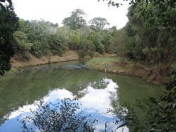
Wilsons River (New South Wales)
Encyclopedia
New South Wales
New South Wales is a state of :Australia, located in the east of the country. It is bordered by Queensland, Victoria and South Australia to the north, south and west respectively. To the east, the state is bordered by the Tasman Sea, which forms part of the Pacific Ocean. New South Wales...
. It was formerly known as Wilsons Creek and the North Arm of the Richmond River
Richmond River
The Richmond River is a river in the north-eastern corner of New South Wales, Australia. It runs for approximately 170 km from the foothills of the Border Ranges past the towns of Kyogle, Casino, Coraki, Woodburn, where it turns northward and empties into the Pacific Ocean at Ballina. It has a...
. It flows into the Richmond River proper at Coraki
Coraki, New South Wales
Coraki is a small town that sits on the confluence of the Richmond and Wilson Rivers in northern New South Wales, Australia in Richmond Valley Shire. At the 2006 census, Coraki had a population of 1,180 people...
. Wilsons Creek was named after William Wilson, the first settler in Lismore, in the period 1844-5. In 1976 it was re-named the Wilsons River. It rises in the eastern section of the Nightcap National Park
Nightcap National Park
Nightcap National Park is in New South Wales, Australia, 35 km north of Lismore. It is classed by the IUCN World Commission on Protected Areas as Category II...
and flows southwest through Lismore
Lismore, New South Wales
Lismore is a subtropical town in northeastern New South Wales, Australia. Lismore is the main population centre in the City of Lismore local government area. Lismore is a regional centre in the Northern Rivers region of the State.-History:...
and then south to Coraki.
Floods
The Wilsons River floods regularly, and on occasion, has inundated Lismore. It's for this reason that many of Lismore's homes are built elevated, in a fashion known as hiset and why Lismore has extensive leveeLevee
A levee, levée, dike , embankment, floodbank or stopbank is an elongated naturally occurring ridge or artificially constructed fill or wall, which regulates water levels...
systems to protect the city from all but the worst floods.
The frequency of flooding is due to several contributing factors. One is the relatively high rainfall in the headwaters of the system (The Rummery Park Rain Gauge is the Wettest in NSW) and the unusual geomorphology
Geomorphology
Geomorphology is the scientific study of landforms and the processes that shape them...
which means that the River flows away from the sea for a significant distance then south after reaching Lismore before joining the Richmond River which eventually flows north east to the Pacific Ocean. In fact the headwaters of the Wilsons River are approximately 180 km from the ocean despite parts of the catchment being less than 2 km from the ocean. Additionally, the balance of the catchment is located near sea level reducing the hydraulic gradient and slowing the rate at which water can flow.
The flood plain of the Wilsons River is quite large. The main flood plain starts near the rivers confluence with Byron Creek and extends all the way to Coraki where it joins the Richmond River and its flood plain. In places the flood plain can be several kilometres wide. The flood plain, like others around the world is generally quite fertile, albeit quite clayey. However, the high frequency of flooding limits its use mainly to pastures for cattle grazing and dairying enterprises.
Historical river trade
It is likely that the indigenous population of the region would have used canoes and other river craft to transport themselves and trade along the Wilsons river before the appearance of Europeans.Following the arrival of the first Europeans many of the towns and villages along the Wilsons River including Lismore, Wyrallah
Wyrallah, New South Wales
Wyrallah, New South Wales is a historical village in the Northern Rivers region of New South Wales, Australia. It is located within the City of Lismore local government area....
, Bexhill and Coraki
Coraki, New South Wales
Coraki is a small town that sits on the confluence of the Richmond and Wilson Rivers in northern New South Wales, Australia in Richmond Valley Shire. At the 2006 census, Coraki had a population of 1,180 people...
, were located or developed at their present sites due to the most effective form of transport at the time, river going ships and boats. The Wilsons River, then known as the North Arm of the Richmond River, and the Richmond River
Richmond River
The Richmond River is a river in the north-eastern corner of New South Wales, Australia. It runs for approximately 170 km from the foothills of the Border Ranges past the towns of Kyogle, Casino, Coraki, Woodburn, where it turns northward and empties into the Pacific Ocean at Ballina. It has a...
itself was named and charted by Henry John Rous
Henry John Rous
Admiral Henry John Rous was a Royal Navy officer and sportsman.-Career:Born the second son of John Rous, 1st Earl of Stradbroke, Rous was educated at Westminster School, and entered the Royal Navy in 1808, serving as a midshipman in the Walcheren Campaign the following year...
in 1828. It was the furthest navigable section of the river system and provided the access necessary for shipping out the region’s most valuable commodity at the time with was the red cedar
Toona ciliata
Australian Red Cedar , Toona ciliata is a forest tree in the family Meliaceae which grows throughout southern Asia from Afghanistan to Papua New Guinea and Australia. In Australia its natural habitat is now extensively cleared subtropical rainforests of New South Wales and Queensland...
which was to be steadily cut from the Big Scrub
Big Scrub
The Big Scrub was the largest area of subtropical lowland rainforest in eastern Australia. It was intensively cleared for agricultural use in the 19th century by colonists...
subtropical rainforest that once covered most of the region.
Goods regularly transported early in the 20th century included bacon, maize, eggs, butter, tallow, poulty and sawn logs. Ships included the Cavanba, Tomki, City of Grafton and Wyoming.)
The last transport shipping company to operate on the Richmond and Wilsons River systems closed in the 1960s.
Tributaries
The Wilsons River has several significant tributaries, namely, Leycester Creek, Coopers Creek, Pearces Creek and Byron Creek. With Leycester Creek the most downstream major tributary. Additionally, there are numerous other smaller named and unnamed tributaries that join the river.Leycester Creek joins the Wilsons River at Lismore which when in flood at the same time can cause higher than expected flooding at the city. This is particuarly caused by the angles of confluence which can direct flow towards the main Lismore Levee.
The confluence with Coopers Creek is near the village of Bexhill at Boat Harbour Nature Reserve which is one of the largest remnants of the Big Scrub rainforest. It is also the furthest upstream tidal location on the river.
Byron Creek has its head waters only 2 km from the pacific ocean. So, like most of the Wilsons River system it is unusual for a coastal river system because if flows inland for a significant distance.
The Wilsons River is itself a tributary of the Richmond River which it joins at Coraki.
Water supply
The Wilsons River is the source of a potable water for a large part of the region. Byron Shire Council obtain water from Lavertys Gap Weir on the river. This water is treated at the nearby water treatment plant to supply potable water to the town of Mullumbimby.Rous Water obtain water from the fresh water tidal pool upstream of Lismore to supplement the Rocky Creek Dam
Rocky Creek Dam
Rocky Creek Dam is a drinking water catchment dam on the North Coast of New South Wales, Australia. The dam forms the waterbody known as Rocky Lake...
supply to large parts of the Byron Shire Council, Ballina Shire, Richmond Valley Council and City of Lismore
City of Lismore
The City of Lismore is a local government area in New South Wales, Australia. Its primary city, Lismore is a major regional centre in the Northern Rivers region of the state.-Demographics:...
local government areas. This water is pumped to and treated at the Nightcap Water Treatment Plant near Rocky Creek Dam and is reticulated back to the council areas by gravity.
Farmers in the region also use the Wilsons River to supply water for irrigation (mainly pastures) and for stock watering and some domestic supplies. Water in the Coopers Creek tributary has been historically over-allocated and is therefore the subject of a water sharing plan developed by the NSW Government.