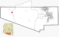
Why, Arizona
Encyclopedia

Unincorporated area
In law, an unincorporated area is a region of land that is not a part of any municipality.To "incorporate" in this context means to form a municipal corporation, a city, town, or village with its own government. An unincorporated community is usually not subject to or taxed by a municipal government...
in Pima County
Pima County, Arizona
-2010:Whereas according to the 2010 U.S. Census Bureau:*74.3% White*3.5% Black*3.3% Native American*2.6% Asian*0.2% Native Hawaiian or Pacific Islander*3.7% Two or more races*12.4% Other races*34.6% Hispanic or Latino -2000:...
, Arizona
Arizona
Arizona ; is a state located in the southwestern region of the United States. It is also part of the western United States and the mountain west. The capital and largest city is Phoenix...
, United States
United States
The United States of America is a federal constitutional republic comprising fifty states and a federal district...
. It lies near the western border of the Tohono O'Odham Indian Reservation
Tohono O'odham
The Tohono O'odham are a group of Native American people who reside primarily in the Sonoran Desert of the southeastern Arizona and northwest Mexico...
and due north of Organ Pipe Cactus National Monument
Organ Pipe Cactus National Monument
Organ Pipe Cactus National Monument is a U.S. National Monument and UNESCO biosphere reserve located in extreme southern Arizona which shares a border with the Mexican state of Sonora. The park is the only place in the United States where the Organ Pipe Cactus grows wild...
in Southern Arizona
Southern Arizona
Southern Arizona is a region of the United States comprising the southernmost portion of the State of Arizona. It sometimes goes by the name Baja Arizona, which means "Lower Arizona" in Spanish.- Geography :...
. It is approximately thirty miles north of the Mexican border where Lukeville, Arizona
Lukeville, Arizona
Lukeville is a small unincorporated community on the U.S.-Mexico border in southern Pima County, Arizona, United States.The community consists of the international border crossing into Sonoyta, Sonora, Mexico, together with a gas station, a duty free shop, a few outlets that sell Mexican automobile...
, and Sonoita, Sonora, Mexico
Mexico
The United Mexican States , commonly known as Mexico , is a federal constitutional republic in North America. It is bordered on the north by the United States; on the south and west by the Pacific Ocean; on the southeast by Guatemala, Belize, and the Caribbean Sea; and on the east by the Gulf of...
, border each other, and ten miles south of Ajo, Arizona
Ajo, Arizona
Ajo is a census-designated place in Pima County, Arizona, United States. The population was 3,705 at the 2000 census. Ajo is located on State Route 85 just from the Mexican border. It is the closest community to Organ Pipe Cactus National Monument....
.
The population in Why at the 2000 census
United States Census, 2000
The Twenty-second United States Census, known as Census 2000 and conducted by the Census Bureau, determined the resident population of the United States on April 1, 2000, to be 281,421,906, an increase of 13.2% over the 248,709,873 persons enumerated during the 1990 Census...
was approximately 116.
History
The unusual name of the town comes from the fact that the two major highways, State Routes 85 and 86, originally intersected in a Y-intersection. At the time of its naming, Arizona law required all city names to have at least three letters, so the town's founders named the town "Why" as opposed to simply calling it "Y." The Arizona Department of TransportationArizona Department of Transportation
The Arizona Department of Transportation is an Arizona state government agency charged with facilitating mobility within the state. In addition to managing the state's highway system, the agency is also involved with public transportation and municipal airports...
(ADOT) later removed the old Y-intersection for traffic safety reasons and built the two highways in a conventional T-intersection
Intersection (road)
An intersection is a road junction where two or more roads either meet or cross at grade . An intersection may be 3-way - a T junction or fork, 4-way - a crossroads, or 5-way or more...
south of the original intersection.
External links
- Mapquest Map
- Google Maps
- Aerial Photos Google Earth
- Weather www.wunderground.com

