
White Pine Trail State Park
Encyclopedia
Fred Meijer White Pine Trail State Park is a 92 miles (148.1 km) long linear
Linear park
A linear park is a park that is much longer than wide. It is often formed as a part of a rails-to-trails conversion of railroad beds to rail trail recreational use...
state park
State park
State parks are parks or other protected areas managed at the federated state level within those nations which use "state" as a political subdivision. State parks are typically established by a state to preserve a location on account of its natural beauty, historic interest, or recreational...
in the U.S. state
U.S. state
A U.S. state is any one of the 50 federated states of the United States of America that share sovereignty with the federal government. Because of this shared sovereignty, an American is a citizen both of the federal entity and of his or her state of domicile. Four states use the official title of...
of Michigan
Michigan
Michigan is a U.S. state located in the Great Lakes Region of the United States of America. The name Michigan is the French form of the Ojibwa word mishigamaa, meaning "large water" or "large lake"....
.
The trail extends from northern Grand Rapids
Grand Rapids, Michigan
Grand Rapids is a city in the U.S. state of Michigan. The city is located on the Grand River about 40 miles east of Lake Michigan. As of the 2010 census, the city population was 188,040. In 2010, the Grand Rapids metropolitan area had a population of 774,160 and a combined statistical area, Grand...
to Cadillac
Cadillac, Michigan
Cadillac is a city in the U.S. state of Michigan and is the county seat of Wexford County. As of the 2000 census, the city population was 10,000. The city is situated at the junction of US 131, M-55 and M-115...
, and it lies on the path graded for the Grand Rapids and Indiana Railroad
Grand Rapids and Indiana Railroad
The Grand Rapids and Indiana Railroad at its height provided passenger and freight railroad services between Cincinnati, Ohio and the Straits of Mackinac in Michigan, USA...
. The White Pine Trail is a rail trail
Rail trail
A rail trail is the conversion of a disused railway easement into a multi-use path, typically for walking, cycling and sometimes horse riding. The characteristics of former tracks—flat, long, frequently running through historical areas—are appealing for various development. The term sometimes also...
park. It was named the "Fred Meijer White Pine Trail State Park" after a donation by Fred Meijer
Fred Meijer (businessman)
Frederik Gerhard Hendrik Meijer was the Chairman of the Meijer hypermarket chain in Michigan, United States.-Biography:...
.
History
As the railroad ceased operation in the mid-1980s, the Michigan Department of TransportationMichigan Department of Transportation
The Michigan Department of Transportation is a constitutional government agency in the US state of Michigan. The primary purpose of MDOT is to maintain the Michigan State Trunkline Highway System which includes all Interstate, US and state highways in Michigan with the exception of the Mackinac...
came to own the rail bed. By 1994 the property was transferred to the Michigan Department of Natural Resources
Michigan Department of Natural Resources
The Michigan Department of Natural Resources is the agency of the state of Michigan charged with maintaining natural resources such as state parks, state forests, and recreation areas. It is governed by a director appointed by the Governor and accepted by the Natural Resources Commission...
, which began replacing the rails with a trail for public recreational use.
Current Condition
The trail extends from Ann Street in Grand Rapids north to Cadillac. The trail has three paved sections: one extending 22 miles (35.4 km) between Comstock ParkComstock Park, Michigan
Comstock Park is a prosperous suburban community in the northern part of Metropolitan Grand Rapids, Michigan, United States, that comprises parts of three neighboring townships:* Plainfield Township* Alpine Township* Algoma Township...
and Sand Lake
Sand Lake, Michigan
Sand Lake is a village in Kent County in the U.S. state of Michigan. The population was 492 at the 2000 census.-Geography:According to the United States Census Bureau, the village has a total area of , of which, of it is land and of it is water....
, another 13 miles (20.9 km) stretch between Big Rapids
Big Rapids, Michigan
Big Rapids is a city in the U.S. state of Michigan. As of the 2000 census, the city population was 10,849. It is the county seat of Mecosta County. The city is located within Big Rapids Township, but is politically independent.-Geography:...
and Reed City
Reed City, Michigan
Reed City is a city in the U.S. state of Michigan. As of the 2000 census, the city population was 2,430. It is the county seat of Osceola County.It is the home town of author Timothy James Bazzett.-Geography:...
, and a 16 mile stretch between Leroy and Cadillac. The Michigan DNR has plans to pave 7.6 miles (12.2 km) of trail from Russel Road near Cedar Springs to Sand Lake during the summer of 2007.(Completed)
Unpaved sections of the trail are surfaced with packed gravel or cinder
Cinder
A cinder is a pyroclastic material. Cinders are extrusive igneous rocks. Cinders are similar to pumice, which has so many cavities and is such low-density that it can float on water...
s.
Snowmobiles are permitted to ride the trail North of the Russell Road trailhead to South Street in Cadillac.
Due to reduced public funding for state parks in Michigan, the trail's upkeep depends largely on volunteers.
Communities Along Trail
The trail passes through the following communities:- Comstock Park, MichiganComstock Park, MichiganComstock Park is a prosperous suburban community in the northern part of Metropolitan Grand Rapids, Michigan, United States, that comprises parts of three neighboring townships:* Plainfield Township* Alpine Township* Algoma Township...
- Belmont, Michigan
- Rockford, MichiganRockford, MichiganRockford is a city in Kent County in the U.S. state of Michigan. As of the 2010 census, the city population was 5,719. It is on the Rogue River and is only a few miles north of Grand Rapids.- History :...
- Cedar Springs, MichiganCedar Springs, MichiganCedar Springs is a city in Kent County in the U.S. state of Michigan, 20 minutes north of Grand Rapids. Known as "Red Flannel Town", the city is home to an annual Red Flannel Festival...
- Sand Lake, MichiganSand Lake, MichiganSand Lake is a village in Kent County in the U.S. state of Michigan. The population was 492 at the 2000 census.-Geography:According to the United States Census Bureau, the village has a total area of , of which, of it is land and of it is water....
- Pierson, MichiganPierson, MichiganPierson is a village in Montcalm County of the U.S. state of Michigan. As of the 2000 census, the village population was 185. The village is within Pierson Township....
- Howard City, MichiganHoward City, MichiganHoward City is a village in Montcalm County in the U.S. state of Michigan. The population was 1,585 at the 2000 census. The village is within Reynolds Township.-History:...
- Morley, MichiganMorley, MichiganMorley is a village in Deerfield Township, Mecosta County in the U.S. state of Michigan. The population was 495 at the 2000 census.-Geography:...
- Stanwood, MichiganStanwood, MichiganStanwood is a village in Mecosta County of the U.S. state of Michigan. As of the 2000 census, the village population was 204. The village is within Mecosta Township.-Geography:...
- Big Rapids, MichiganBig Rapids, MichiganBig Rapids is a city in the U.S. state of Michigan. As of the 2000 census, the city population was 10,849. It is the county seat of Mecosta County. The city is located within Big Rapids Township, but is politically independent.-Geography:...
- Paris, Michigan
- Reed City, MichiganReed City, MichiganReed City is a city in the U.S. state of Michigan. As of the 2000 census, the city population was 2,430. It is the county seat of Osceola County.It is the home town of author Timothy James Bazzett.-Geography:...
- Ashton, Michigan
- Le Roy, MichiganLe Roy, MichiganLe Roy is a village in Osceola County of the U.S. state of Michigan. As of the 2000 census, the village population was 267. The village is located within Le Roy Township.-Geography:...
- Tustin, MichiganTustin, MichiganTustin is a village in Osceola County of the U.S. state of Michigan. As of the 2000 census, the village population was 237. The village is within Burdell Township.-Geography:...
- Cadillac, MichiganCadillac, MichiganCadillac is a city in the U.S. state of Michigan and is the county seat of Wexford County. As of the 2000 census, the city population was 10,000. The city is situated at the junction of US 131, M-55 and M-115...
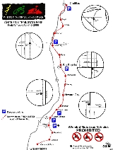
Waypoints
WaypointsWaypoint
A waypoint is a reference point in physical space used for purposes of navigation.-Concept:Waypoints are sets of coordinates that identify a point in physical space. Coordinates used can vary depending on the application. For terrestrial navigation these coordinates can include longitude and...
for the Fred Meijer White Pine Trail State Park.
↑ in the Distance column points to the other waypoint that the distance is between.
| Location | Services | Distance (approx.) | Coordinates |
|---|---|---|---|
| Cadillac, Michigan Cadillac, Michigan Cadillac is a city in the U.S. state of Michigan and is the county seat of Wexford County. As of the 2000 census, the city population was 10,000. The city is situated at the junction of US 131, M-55 and M-115... |
Parking, Restroom | 44.24685°N 85.40022°W | |
| Waypoint 2 | Parking, Restroom | ↑ 2.2 miles (3.5 km) | 44.22267°N 85.42691°W |
| Tustin, Michigan Tustin, Michigan Tustin is a village in Osceola County of the U.S. state of Michigan. As of the 2000 census, the village population was 237. The village is within Burdell Township.-Geography:... |
Drinking Fountain, Restroom | ↑ 8.5 miles (13.7 km) | 44.1024°N 85.45803°W |
| Le Roy, Michigan Le Roy, Michigan Le Roy is a village in Osceola County of the U.S. state of Michigan. As of the 2000 census, the village population was 267. The village is located within Le Roy Township.-Geography:... |
Drinking Fountain, Restroom | ↑ 4.5 miles (7.2 km) | 44.03851°N 85.45007°W |
| Reed City, Michigan Reed City, Michigan Reed City is a city in the U.S. state of Michigan. As of the 2000 census, the city population was 2,430. It is the county seat of Osceola County.It is the home town of author Timothy James Bazzett.-Geography:... |
Drinking Fountain, Restroom | ↑ 12 miles (19.3 km) | 43.87797°N 85.509°W |
| Paris, Michigan | Drinking Fountain, Restroom | ↑ 6.2 miles (10 km) | 43.78886°N 85.50225°W |
| Big Rapids, Michigan Big Rapids, Michigan Big Rapids is a city in the U.S. state of Michigan. As of the 2000 census, the city population was 10,849. It is the county seat of Mecosta County. The city is located within Big Rapids Township, but is politically independent.-Geography:... |
↑ 5 miles (8 km) | 43.71775°N 85.4859°W | |
| Morley, Michigan Morley, Michigan Morley is a village in Deerfield Township, Mecosta County in the U.S. state of Michigan. The population was 495 at the 2000 census.-Geography:... |
Drinking Fountain, Parking, Restroom | ↑ 16 miles (25.7 km) | 43.49053°N 85.44503°W |
| Howard City, Michigan Howard City, Michigan Howard City is a village in Montcalm County in the U.S. state of Michigan. The population was 1,585 at the 2000 census. The village is within Reynolds Township.-History:... |
Drinking Fountain, Restroom | ↑ 6.5 miles (10.5 km) | 43.39688°N 85.47005°W |
| Cedar Springs, Michigan Cedar Springs, Michigan Cedar Springs is a city in Kent County in the U.S. state of Michigan, 20 minutes north of Grand Rapids. Known as "Red Flannel Town", the city is home to an annual Red Flannel Festival... |
Parking | ↑ 16 miles (25.7 km) | 43.18371°N 85.56659°W |
| Comstock Park, Michigan Comstock Park, Michigan Comstock Park is a prosperous suburban community in the northern part of Metropolitan Grand Rapids, Michigan, United States, that comprises parts of three neighboring townships:* Plainfield Township* Alpine Township* Algoma Township... |
↑ 12.1 miles (19.5 km) | 43.02494°N 85.66562°W |
Plans
According to the Friends of the White Pine Trail, there are plans to extend the paved areas of the trail. The trail may also be connected to other trail systems in the state, including the Kent Trails system in Grand Rapids and the Musketawa Trail, much as the White Pine Trail already connects with the Pere Marquette State TrailPere Marquette State Trail
The Pere Marquette State Trail is a bicycle and multi-use trail in west-central lower Michigan, running through Clare, Lake, and Osceola Counties. Intersecting with the White Pine Trail in Reed City, the trail is paved in areas, particularly between Reed City and the Village of Hersey, with a...
in Reed City
Reed City, Michigan
Reed City is a city in the U.S. state of Michigan. As of the 2000 census, the city population was 2,430. It is the county seat of Osceola County.It is the home town of author Timothy James Bazzett.-Geography:...
.