
Whatfield
Encyclopedia
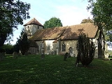
Whatfield is a village and civil parish
in Suffolk
, England
. Located around two miles north of Hadleigh, it is part of Babergh
district. The Calves Wood, a County Wldlife Site (CWS) in the north of the parish
is classed as Ancient Woodland
, whilst the parish's south-western border is delineated by the River Brett.
The Parish Council holds two meadows and a piece of rough woodland in trust for the villagers. The woodland is on the left-hand side of a pleasant walk down to the river Brett.
The first meadow, known as Buckle's Meadow, or Buckledees Meadow by some older parishioners, was purchased in the 1960s with money raised in the village and a grant.
It is a county wildlife site.
Access is by public footpath from Rectory Road.
The second meadow, also accessible by public footpath, is called Hunty's Vale. It was the kind gift to the village by the sisters Edith and Francis Vale who were parishioners.
A programme of conservation is on-going to maintain and improve the area for plants, animals and birds as well as being a pleasant place to walk.
Civil parish
In England, a civil parish is a territorial designation and, where they are found, the lowest tier of local government below districts and counties...
in Suffolk
Suffolk
Suffolk is a non-metropolitan county of historic origin in East Anglia, England. It has borders with Norfolk to the north, Cambridgeshire to the west and Essex to the south. The North Sea lies to the east...
, England
England
England is a country that is part of the United Kingdom. It shares land borders with Scotland to the north and Wales to the west; the Irish Sea is to the north west, the Celtic Sea to the south west, with the North Sea to the east and the English Channel to the south separating it from continental...
. Located around two miles north of Hadleigh, it is part of Babergh
Babergh
Babergh is a local government district in Suffolk, England. Its council headquarters is based in Hadleigh, whilst its largest town is Sudbury.The district was formed on 1 April 1974 by the merger of the Borough of Sudbury, Hadleigh urban district, Cosford Rural District, Melford Rural District and...
district. The Calves Wood, a County Wldlife Site (CWS) in the north of the parish
Parish
A parish is a territorial unit historically under the pastoral care and clerical jurisdiction of one parish priest, who might be assisted in his pastoral duties by a curate or curates - also priests but not the parish priest - from a more or less central parish church with its associated organization...
is classed as Ancient Woodland
Ancient woodland
Ancient woodland is a term used in the United Kingdom to refer specifically to woodland that has existed continuously since 1600 or before in England and Wales . Before those dates, planting of new woodland was uncommon, so a wood present in 1600 was likely to have developed naturally...
, whilst the parish's south-western border is delineated by the River Brett.
The Parish Council holds two meadows and a piece of rough woodland in trust for the villagers. The woodland is on the left-hand side of a pleasant walk down to the river Brett.
The first meadow, known as Buckle's Meadow, or Buckledees Meadow by some older parishioners, was purchased in the 1960s with money raised in the village and a grant.
It is a county wildlife site.
Access is by public footpath from Rectory Road.
The second meadow, also accessible by public footpath, is called Hunty's Vale. It was the kind gift to the village by the sisters Edith and Francis Vale who were parishioners.
A programme of conservation is on-going to maintain and improve the area for plants, animals and birds as well as being a pleasant place to walk.