
West Rounton
Encyclopedia
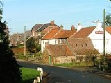
West Rounton is a village and civil parish
in the Hambleton
district of North Yorkshire
, England
. It is near East Rounton
and 8 miles north of Northallerton
.
West Rounton is about 1 mile away from East Rounton across the fields and has the church of St Oswald and two pubs, The Grey Horse which is now closed and The Horseshoe Inn.

Civil parish
In England, a civil parish is a territorial designation and, where they are found, the lowest tier of local government below districts and counties...
in the Hambleton
Hambleton
Hambleton is a local government district of North Yorkshire, England. The main town and administrative centre is Northallerton, and includes the market towns and major villages of Bedale, Thirsk, Great Ayton, Stokesley and Easingwold....
district of North Yorkshire
North Yorkshire
North Yorkshire is a non-metropolitan or shire county located in the Yorkshire and the Humber region of England, and a ceremonial county primarily in that region but partly in North East England. Created in 1974 by the Local Government Act 1972 it covers an area of , making it the largest...
, England
England
England is a country that is part of the United Kingdom. It shares land borders with Scotland to the north and Wales to the west; the Irish Sea is to the north west, the Celtic Sea to the south west, with the North Sea to the east and the English Channel to the south separating it from continental...
. It is near East Rounton
East Rounton
East Rounton is a village and civil parish in the Hambleton district of North Yorkshire, England. It is about 1 mile west of the A19 and 8 miles north east of Northallerton. It is on the River Wiske and West Rounton is nearby....
and 8 miles north of Northallerton
Northallerton
Northallerton is an affluent market town and civil parish in the Hambleton district of North Yorkshire, England. It lies in the Vale of Mowbray and at the northern end of the Vale of York. It has a population of 15,741 according to the 2001 census...
.
West Rounton is about 1 mile away from East Rounton across the fields and has the church of St Oswald and two pubs, The Grey Horse which is now closed and The Horseshoe Inn.