
West Penn Railways
Encyclopedia
Interurban
An interurban, also called a radial railway in parts of Canada, is a type of electric passenger railroad; in short a hybrid between tram and train. Interurbans enjoyed widespread popularity in the first three decades of the twentieth century in North America. Until the early 1920s, most roads were...
electric railway headquartered in Connellsville
Connellsville, Pennsylvania
Connellsville is a city in Fayette County, Pennsylvania, USA, 57 miles southeast of Pittsburgh on the Youghiogheny River, a tributary of the Monongahela River. It is part of the Pittsburgh Metro Area. In 1890, 5,629 people lived in Connellsville, which was a borough at that time...
, Pennsylvania
Pennsylvania
The Commonwealth of Pennsylvania is a U.S. state that is located in the Northeastern and Mid-Atlantic regions of the United States. The state borders Delaware and Maryland to the south, West Virginia to the southwest, Ohio to the west, New York and Ontario, Canada, to the north, and New Jersey to...
. It was part of the region's power generation utility.
History
West Penn Railways consisted of 339 miles (545.6 km) of railway at its peak. Some of its predecessor companies had operated as early as 1889 in the Greensburg area and 1863 in the Wheeling area. West Penn Railways Company, as a distinct corporate entity, was chartered on February 18, 1904. It operated until August 9, 1952, when its last car ran from UniontownUniontown, Pennsylvania
Uniontown is a city in Fayette County, Pennsylvania, southeast of Pittsburgh and part of the Pittsburgh Metro Area. Population in 1900, 7,344; in 1910, 13,344; in 1920, 15,692; and in 1940, 21,819. The population was 10,372 at the 2010 census...
to Greensburg. Because much of its business was to take residents of outlying areas into the nearby towns for shopping and entertainment, its business declined with the construction of better roads and increased car ownership and use. There was evening business after the mines let out with residents going to town to attend movies. An unsubstantiated story holds that once television reached this part of Pennsylvania that West Penn's management, facing increasing loss of riders, decided to abandon railway operations. At one point, the well maintained big orange cars carried signs reading, "To keep the 5c fare we need more riders".
Like most interurbans, West Penn's traction equipment was powered by overhead electric lines. The cars themselves were larger and heavier than typical city streetcars, and were painted bright orange. West Penn's broad gauge single track was laid in streets in towns, but out in the countryside the track often ran on a right-of-way separate from roads. At some points, the West Penn's single track would reenter a road in order to use a road bridge and run not in the center but on one side, and motorists had the unusual problem of having to face a trolley approaching them head on in their lane. In the country there were passing sidings at various points and a crude but effective block signal system. West Penn had some very substantial bridges crossing ravines and valleys. Also, as was typical for interurbans, stops were more frequent than for a conventional railroad, curves were tighter, and gradients (slopes) were steeper. Although interurbans such as West Penn Railways were a short-lived phenomenon, they played a key role in rural passenger transportation in the pre-automobile poor road era.
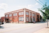
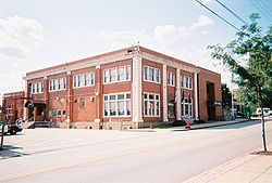
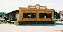
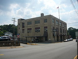
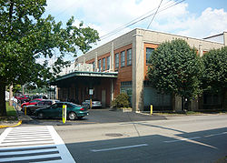
The depot building in Greensburg (constructed in 1927) still stands at 416 South Main Street and is now used as the Greensburg City Hall. The freight station in Greensburg, slightly to the west of City Hall, is being used as the Greensburg Volunteer Fire Department Museum. In Connellsville, the former West Penn depot is a three story structure now used as a bank at 125 South Arch Street. In Uniontown, the former depot (11 East Penn Street), built in 1932, is used as a business school.
Coke Region lines
The bulk of West Penn Railways' trackage formed a network in Allegheny, Westmoreland, and Fayette counties of Pennsylvania, comprising 158 miles (254.3 km) in 1917, with headquarters in Connellsville. The main line ran from Greensburg, through Hecla (now known as SouthwestSouthwest, Pennsylvania
Southwest is an unincorporated community in Westmoreland County, Pennsylvania, United States near Pennsylvania Route 981. It has the ZIP code 15685.-References:* *...
), Mount Pleasant
Mount Pleasant, Pennsylvania
Mount Pleasant is a borough in Westmoreland County, Pennsylvania, in the United States. It stands 45 miles southeast of Pittsburgh. Population in 1900, 4,745 people; in 1910, 5,812 people; and in 1940, 5,824 people...
, Scottdale
Scottdale, Pennsylvania
Scottdale is a borough in Westmoreland County, Pennsylvania, southeast of Pittsburgh. Scottdale is the home of the Southmoreland Scotties. Early in the 20th century, Scottdale was the center of the Frick coke interests...
, Connellsville
Connellsville, Pennsylvania
Connellsville is a city in Fayette County, Pennsylvania, USA, 57 miles southeast of Pittsburgh on the Youghiogheny River, a tributary of the Monongahela River. It is part of the Pittsburgh Metro Area. In 1890, 5,629 people lived in Connellsville, which was a borough at that time...
, and Uniontown
Uniontown, Pennsylvania
Uniontown is a city in Fayette County, Pennsylvania, southeast of Pittsburgh and part of the Pittsburgh Metro Area. Population in 1900, 7,344; in 1910, 13,344; in 1920, 15,692; and in 1940, 21,819. The population was 10,372 at the 2010 census...
, a distance of 31 miles (49.9 km). This trip took 2 hours 25 minutes, with service provided every half hour. The speed averaged approximately 13 mi/h, including stops. The ridership was almost entirely local in nature; most passengers rode only a few miles (mainly from their homes to the nearest town for shopping, or to go to work). Service ended on August 9, 1952.
The phrase "Coke Region" is based on the area's fame for producing coke (fuel)
Coke (fuel)
Coke is the solid carbonaceous material derived from destructive distillation of low-ash, low-sulfur bituminous coal. Cokes from coal are grey, hard, and porous. While coke can be formed naturally, the commonly used form is man-made.- History :...
from coal. The coke industry suffered a major blow in the 1920s after byproduct ovens were built near the Pittsburgh steel mills, rendering the "beehive" facilities that dotted West Penn's territory nearly obsolete. As a result the trolleys had fewer passengers to take to work, and the decline began in earnest.
Branches and minor lines were as follows. (Date of last rail service is in parentheses.)
- McKeesport - Wilmerding (1904)
- McKeesport - Lincoln Way (1924)
- Locust Street, McKeesport (1925)
- Jerome Street, McKeesport (1928)
- Scottdate - Meadow Mill (1931)
- Boston - Scott Haven (1932)
- Greensburg - Bunker Hill (1934)
- Tarr - Mount Pleasant (1936)
- Irwin - McKeesport (1938)
- Greensburg - Hunker - Scottdale (1939)
- Larimer - Trafford (1942)
- Irwin - Larimer (1948)
- Uniontown - Brownsville (1950)
- Uniontown - Martin (1950)
- Uniontown - Fairchance (1950)
- Connellsville - Dickerson Run (1951)
- Connellsville - Phillips - Uniontown (parallel to the main line but separate) (1951)
- Irwin - Greensburg (1952)
- Latrobe - Hecla (now Southwest) (1952)
- Connellsville - South Connellsville (1952)
Noncontiguous lines
There were five other components of West Penn Railways which did not connect to each other or to the main network of "Coke Region" tracks:- Allegheny Valley Street Railway: This line ran parallel to the Allegheny RiverAllegheny RiverThe Allegheny River is a principal tributary of the Ohio River; it is located in the Eastern United States. The Allegheny River joins with the Monongahela River to form the Ohio River at the "Point" of Point State Park in Downtown Pittsburgh, Pennsylvania...
northeast of Pittsburgh, running from AspinwallAspinwall, PennsylvaniaAspinwall is a borough on the Allegheny River in Allegheny County, Pennsylvania, United States, and is part of the Pittsburgh Metro Area. It is essentially a residential place. In 1900, 1,231 people resided in Aspinwall, and that number rose to 2,592 in 1910, and 3,170 by 1920...
to NatronaNatrona, PennsylvaniaNatrona is an unincorporated community in Harrison Township, Allegheny County in the U.S. state of Pennsylvania. It is located in Western Pennsylvania within the Pittsburgh Metropolitan Statistical Area, approximately northeast of Downtown Pittsburgh...
. A branch crossed the river to serve New KensingtonNew Kensington, PennsylvaniaNew Kensington is a city in Westmoreland County, Pennsylvania situated along the Allegheny River northeast of Pittsburgh. The population was 14,701 at the 2000 Census. The mayor of New Kensington is Tom Guzzo , elected in 2009. He succeeded Mayor Frank E. Link , elected in 2001.-History:New...
, Parnassus, and ArnoldArnold, PennsylvaniaArnold is a city in Westmoreland County in the U.S. state of Pennsylvania. It is a suburb of Pittsburgh, part of the Pittsburgh Metro Area. The population was 5,667 at the 2000 census.-History:...
. Service began in 1906 and ended in 1937.
- ApolloApollo, PennsylvaniaApollo is a borough in Armstrong County, Pennsylvania, United States, 35 miles northeast of Pittsburgh in a former coal-mining region. Apollo was settled in 1790, laid out in 1816, and incorporated as a borough in 1848. The town was originally known as 'Warren', but was later renamed to avoid...
- LeechburgLeechburg, PennsylvaniaLeechburg is a borough in southern Armstrong County in the U.S. state of Pennsylvania, northeast of Pittsburgh. Leechburg was founded by David Leech, for whom it was later named, and was incorporated as a borough in 1850....
: Operated 1906-1936 along the north bank of the Kiskiminetas RiverKiskiminetas RiverThe Kiskiminetas River is a tributary of the Allegheny River, approximately long, in Western Pennsylvania in the United States...
.
- KittanningKittanning, PennsylvaniaKittanning is a borough and the county seat of Armstrong County, Pennsylvania in the United States. It is situated northeast of Pittsburgh, along the east bank of the Allegheny River. The name means "at the great stream" in the Delaware language...
: A line ran from Cowanshannock to Kittanning to Lenape Park (1899-1936). Lenape Park was an amusement park built and operated by the company. This line was built to a 4 foot 8½ inch gauge, the only element of West Penn Railways not built to a 5 feet 2½ inch gauge.
- OakdaleOakdale, PennsylvaniaOakdale is a borough in Allegheny County, Pennsylvania, United States. The population was 1,459 at the 2010 census. Its zip code is 15071.Oakdale is affectionately known as "America's Home Town"...
- McDonaldMcDonald, PennsylvaniaMcDonald is a borough in Allegheny and Washington counties in the U.S. state of Pennsylvania, 18 miles southwest of Pittsburgh. In the past, manufactories of bottles, oil-well drilling tools, flour-mill products, etc., existed here. Oil and coal were and still are procured in the area...
Street Railway: This line connected these two small communities west of Pittsburgh, operating 1907-1927.
- Wheeling Traction Company (Wheeling, West VirginiaWheeling, West VirginiaWheeling is a city in Ohio and Marshall counties in the U.S. state of West Virginia; it is the county seat of Ohio County. Wheeling is the principal city of the Wheeling Metropolitan Statistical Area...
): Service operated from Wheeling south to MoundsvilleMoundsville, West VirginiaMoundsville is a city in Marshall County, West Virginia, along the Ohio River. It is part of the Wheeling Metropolitan Statistical Area. The population was 9,998 at the 2000 census. It is the county seat of Marshall County. The city was named for the Grave Creek Mound. Moundsville was settled in...
, and from Wheeling north to WeirtonWeirton, West VirginiaWeirton is a city located in the Northern Panhandle of West Virginia, United States. Most of the city is in Hancock County, with the remainder in Brooke County. As of the 2000 census, the city population was 20,411...
. Another line ran on the opposite (western) bank of the Ohio RiverOhio RiverThe Ohio River is the largest tributary, by volume, of the Mississippi River. At the confluence, the Ohio is even bigger than the Mississippi and, thus, is hydrologically the main stream of the whole river system, including the Allegheny River further upstream...
, from ShadysideShadyside, OhioShadyside is a village in Belmont County, Ohio, United States, along the Ohio River. It is part of the Wheeling, West Virginia Metropolitan Statistical Area...
to RaylandRayland, OhioRayland is a village in Jefferson County, Ohio, United States, along the Ohio River. The population was 434 at the 2000 census. It is part of the Weirton–Steubenville, WV-OH Metropolitan Statistical Area.-Geography:...
, with a branch to BartonBarton, OhioBarton is an unincorporated community in southern Colerain Township, Belmont County, Ohio, United States, along Wheeling Creek. Although it is unincorporated, it has a post office, with the ZIP code of 43905....
, and a connection by bridge to Wheeling. Another branch connected BrilliantBrilliant, OhioBrilliant is an unincorporated community in eastern Wells Township, Jefferson County, Ohio, United States. It was named after the glass factory that once was located in the town. Previous names include Phillipsburg and La Grange. Its zip code is 43913. It is located along State Route 7.An Ohio...
and Steubenville to the Wheeling-Weirton line. Track length in 1917 was 102 miles (164.2 km). Wheeling's earliest trolley service consisted of horse-drawn trolleys in 1863 and electric trolleys in 1890, although this was prior to West Penn Railways acquiring control in 1906. Control by West Penn Railways ended in 1931, after which an employee-owned cooperative, Co-operative Transit Company, conducted operations on the Wheeling-Barton and Wheeling-Shadyside routes until 1948 when river flooding caused irreparable damage.