

West Garden Grove, Garden Grove, California
Encyclopedia
Community
The term community has two distinct meanings:*a group of interacting people, possibly living in close proximity, and often refers to a group that shares some common values, and is attributed with social cohesion within a shared geographical location, generally in social units larger than a household...
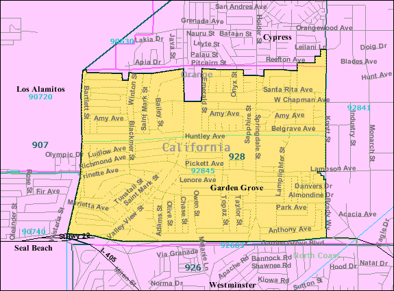
encompassing the western portions of the city of Garden Grove
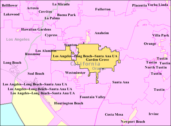
Garden Grove, California
Garden Grove is a city located in northern Orange County, California. The population was 170,883 at the 2010 census. State Route 22, also known as the Garden Grove Freeway, passes through the city running east-west. The city is known outside the Southern California area for being the home of Robert H...
in Orange County, California
Orange County, California
Orange County is a county in the U.S. state of California. Its county seat is Santa Ana. As of the 2010 census, its population was 3,010,232, up from 2,846,293 at the 2000 census, making it the third most populous county in California, behind Los Angeles County and San Diego County...
. The term is used on an unofficial basis and is not recognized by the city of Garden Grove. It is bordered to the north by Cypress
Cypress, California
Cypress is a suburban city located in the northern region of Orange County within Southern California. Its population was 47,802 at the 2010 census.-History:...
, to the west by Los Alamitos
Los Alamitos, California
Los Alamitos is a small city in Orange County, California. The city was incorporated in March 1960. The population was 11,449 at the 2010 census, down from 11,536 at the 2000 census...
and Seal Beach
Seal Beach, California
-Neighborhoods:Seal Beach encompasses the Leisure World retirement gated community with roughly 9,000 residents. This was the first major planned retirement community of its type in the U.S...
, to the south by Westminster
Westminster, California
-Government:In the state legislature Westminster is located in the 34th, Senate District, represented by Democrat Lou Correa and Republican Tom Harman respectively, and in the 67th and 68th Assembly District, represented by Republicans Jim Silva and Van Tran respectively...
, and to the east by Stanton
Stanton, California
Stanton is a city located in western Orange County, California. The population was 38,186 at the 2010 census, up from 37,403 at the 2000 census. Like most of Orange County, it is more politically conservative compared to the rest of the state. The City was incorporated in 1956 and operates under...
, and connected to the rest of Garden Grove by a narrow strip along Garden Grove Boulevard. It includes the entire 92845 ZIP Code
ZIP Code
ZIP codes are a system of postal codes used by the United States Postal Service since 1963. The term ZIP, an acronym for Zone Improvement Plan, is properly written in capital letters and was chosen to suggest that the mail travels more efficiently, and therefore more quickly, when senders use the...
, which is designated as the areas west of Knott Avenue to the Seal Beach and Los Alamitos city borders, and the industrial area east of Knott Avenue to the Stanton border. The community is more affluent than the rest of Garden Grove, with a median income $25,000 greater than the main body of the city. There is also less crime, a lower poverty rate, and the population density is lower compared to the rest of Garden Grove. As of the 2000 Census
United States Census, 2000
The Twenty-second United States Census, known as Census 2000 and conducted by the Census Bureau, determined the resident population of the United States on April 1, 2000, to be 281,421,906, an increase of 13.2% over the 248,709,873 persons enumerated during the 1990 Census...
, 15,864 people reside in West Garden Grove.
Demographics
As of the censusCensus
A census is the procedure of systematically acquiring and recording information about the members of a given population. It is a regularly occurring and official count of a particular population. The term is used mostly in connection with national population and housing censuses; other common...
of 2000 for the 92845 ZIP Code
ZIP Code
ZIP codes are a system of postal codes used by the United States Postal Service since 1963. The term ZIP, an acronym for Zone Improvement Plan, is properly written in capital letters and was chosen to suggest that the mail travels more efficiently, and therefore more quickly, when senders use the...
, there were 15,864 people, 5,589 households, and 5,107 families residing in the community. The population density
Population density
Population density is a measurement of population per unit area or unit volume. It is frequently applied to living organisms, and particularly to humans...
was 7,921.4/mi2. There were 5,589 housing units at an average density of 2,937.5/mi2. The racial makeup of the community was 82.43% White
Race (United States Census)
Race and ethnicity in the United States Census, as defined by the Federal Office of Management and Budget and the United States Census Bureau, are self-identification data items in which residents choose the race or races with which they most closely identify, and indicate whether or not they are...
, 1.06% Black
Race (United States Census)
Race and ethnicity in the United States Census, as defined by the Federal Office of Management and Budget and the United States Census Bureau, are self-identification data items in which residents choose the race or races with which they most closely identify, and indicate whether or not they are...
or African American
Race (United States Census)
Race and ethnicity in the United States Census, as defined by the Federal Office of Management and Budget and the United States Census Bureau, are self-identification data items in which residents choose the race or races with which they most closely identify, and indicate whether or not they are...
, 0.61% Native American
Race (United States Census)
Race and ethnicity in the United States Census, as defined by the Federal Office of Management and Budget and the United States Census Bureau, are self-identification data items in which residents choose the race or races with which they most closely identify, and indicate whether or not they are...
, 9.28% Asian
Race (United States Census)
Race and ethnicity in the United States Census, as defined by the Federal Office of Management and Budget and the United States Census Bureau, are self-identification data items in which residents choose the race or races with which they most closely identify, and indicate whether or not they are...
, 0.37% Pacific Islander
Race (United States Census)
Race and ethnicity in the United States Census, as defined by the Federal Office of Management and Budget and the United States Census Bureau, are self-identification data items in which residents choose the race or races with which they most closely identify, and indicate whether or not they are...
, 2.81% from other races
Race (United States Census)
Race and ethnicity in the United States Census, as defined by the Federal Office of Management and Budget and the United States Census Bureau, are self-identification data items in which residents choose the race or races with which they most closely identify, and indicate whether or not they are...
, and 3.80% from two or more races. 10.93% of the population were Hispanic or Latino
Race (United States Census)
Race and ethnicity in the United States Census, as defined by the Federal Office of Management and Budget and the United States Census Bureau, are self-identification data items in which residents choose the race or races with which they most closely identify, and indicate whether or not they are...
of any race.
There were 5,589 households out of which 34.9% had children under the age of 18 living with them, 64.0% were married couples
Marriage
Marriage is a social union or legal contract between people that creates kinship. It is an institution in which interpersonal relationships, usually intimate and sexual, are acknowledged in a variety of ways, depending on the culture or subculture in which it is found...
living together, 10.3% had a female householder with no husband present, and 21.7% were non-families. 17.2% of all households were made up of individuals and 8.3% had someone living alone who was 65 years of age or older. The average household size was 2.84 and the average family size was 3.21.
In the community the population was spread out with 27.6% under the age of 18, 4.0% from 18 to 24, 30.4% from 25 to 44, 24.3% from 45 to 64, and 13.8% who were 65 years of age or older. The median age was 38.5 years. For every 100 females there were 97.2 males. For every 100 females age 18 and over, there were 95.8 males.
The median income for a household in the community was $66,830, and the median income for a family was $73,850. Males had a median income of $52,165 versus $37,281 for females. The per capita income
Per capita income
Per capita income or income per person is a measure of mean income within an economic aggregate, such as a country or city. It is calculated by taking a measure of all sources of income in the aggregate and dividing it by the total population...
for the city was $26,439. About 4.3% of families and 5.7% of the population were below the poverty line, including 6.2% of those under age 18 and 5.3% of those age 65 or over.
Government
The community receives all its services from the city of Garden GroveGarden Grove, California
Garden Grove is a city located in northern Orange County, California. The population was 170,883 at the 2010 census. State Route 22, also known as the Garden Grove Freeway, passes through the city running east-west. The city is known outside the Southern California area for being the home of Robert H...
. West Garden Grove has different representatives from the rest of Garden Grove in the congressional, State Senate, State Assembly, and County Supervisor Districts. It is served by California's 40th congressional district
California's 40th congressional district
California's 40th congressional district is a congressional district in the U.S. state of California based in Orange County. The district covers cities in the northern part of the county, including Fullerton, Orange, Cypress, Stanton, and Buena Park....
whereas the remainder of the city is served under the California's 44th congressional district
California's 44th congressional district
California's 44th congressional district is a congressional district in the U.S. state of California that currently covers an area of Southern California from San Clemente in Orange County on the coast, north-by-northeast inland to Riverside County, including the cities of Corona, Norco, Rubidoux,...
. The community is served by the 35th California State Senate
California State Senate
The California State Senate is the upper house of the California State Legislature. There are 40 state senators. The state legislature meets in the California State Capitol in Sacramento. The Lieutenant Governor is the ex officio President of the Senate and may break a tied vote...
district whereas the rest of the city is served by the 34th California State Senate
California State Senate
The California State Senate is the upper house of the California State Legislature. There are 40 state senators. The state legislature meets in the California State Capitol in Sacramento. The Lieutenant Governor is the ex officio President of the Senate and may break a tied vote...
district. West Garden Grove is served by the California State Assembly
California State Assembly
The California State Assembly is the lower house of the California State Legislature. There are 80 members in the Assembly, representing an approximately equal number of constituents, with each district having a population of at least 420,000...
district 67, where the rest of the city is served by the 68th district. Within the county, West Garden Grove is within the jurisdiction of District 2 under the Orange County Board of Supervisors
County board of supervisors
The Board of Supervisors is the body that supervises the operation of county government in all counties in Arizona, California, Iowa, Mississippi, Virginia, Wisconsin, and Sussex County, New Jersey as well as a handful of counties in New York...
and the remainder of the city is served under District 1.
- City: Garden Grove, CaliforniaGarden Grove, CaliforniaGarden Grove is a city located in northern Orange County, California. The population was 170,883 at the 2010 census. State Route 22, also known as the Garden Grove Freeway, passes through the city running east-west. The city is known outside the Southern California area for being the home of Robert H...
- U.S. Congressional District: District 40 (Ed RoyceEd RoyceEdward Randall "Ed" Royce is the U.S. Representative for , and previously the 39th, serving in Congress since 1993. He is a member of the Republican Party. The district lies in northern Orange County, including portions of Stanton, Cypress, Buena Park, Fullerton, Anaheim, Placentia, and Orange...
) - California State SenateCalifornia State SenateThe California State Senate is the upper house of the California State Legislature. There are 40 state senators. The state legislature meets in the California State Capitol in Sacramento. The Lieutenant Governor is the ex officio President of the Senate and may break a tied vote...
: District 35 (Tom HarmanTom HarmanThomas George Harman is an American politician. He is a Republican member of the California State Senate who had previously been a three-term member of the California State Assembly. Both seats represent portions of Orange County....
) - California State AssemblyCalifornia State AssemblyThe California State Assembly is the lower house of the California State Legislature. There are 80 members in the Assembly, representing an approximately equal number of constituents, with each district having a population of at least 420,000...
: District 67 (Jim SilvaJim SilvaJames Wayne Silva is a Republican United States politician who represents the 67th Assembly District in the California State Assembly....
) - OrangeOrange County, CaliforniaOrange County is a county in the U.S. state of California. Its county seat is Santa Ana. As of the 2010 census, its population was 3,010,232, up from 2,846,293 at the 2000 census, making it the third most populous county in California, behind Los Angeles County and San Diego County...
County Board of SupervisorsCounty board of supervisorsThe Board of Supervisors is the body that supervises the operation of county government in all counties in Arizona, California, Iowa, Mississippi, Virginia, Wisconsin, and Sussex County, New Jersey as well as a handful of counties in New York...
: District 2 (John MoorlachJohn MoorlachJohn M. W. Moorlach is a Republican member of the Orange County Board of Supervisors and represents the Second District on the board...
)
Parks and Recreation
In West Garden Grove, there are three community parks, Eastgate Park, Westgrove Park, and Edgar Park. The westernmost border is located 4.5 miles from the Pacific OceanPacific Ocean
The Pacific Ocean is the largest of the Earth's oceanic divisions. It extends from the Arctic in the north to the Southern Ocean in the south, bounded by Asia and Australia in the west, and the Americas in the east.At 165.2 million square kilometres in area, this largest division of the World...
. In the eastern part of the community, an abundant supply of jobs are located in the industrial park east of Knott Avenue. There are three strip malls in the community located along Valley View Street. The Garden Grove West Library is located west of Valley View Street on the corner of Chapman and Bailey Street.
Education
West Garden Grove is served under the Garden Grove Unified School DistrictGarden Grove Unified School District
The Garden Grove Unified School District is the third largest school district in Orange County, and the twelfth largest in the State of California...
, and has 8 schools located within its boundaries; 5 elementary schools, 1 intermediate school, and 1 high school. There are no colleges, or universities within the community limits, nor are there any special education schools.
Elementary Schools
- Edgar School, now used as a GGUSD meeting center
- Loyal Barker Elementary School
- Garden Park School
- Enders Elementary School
- Patton Elementary School
- Hettinga Elementary School, now used for adult education
Intermediate Schools
- Hilton D. Bell Intermediate School
- Chapman Junior High School (now used for adult education)
North to South
- Valley View Street
- Springdale Street
- Knott Avenue/Street (changes from Avenue to Street)
- Western AvenueWestern AvenueWestern Avenue, some 10 miles in length, is one of the major roads leading out of London, England. It is part of the A40, leaving the city in a north-westerly direction...
See also
- Garden Grove, CaliforniaGarden Grove, CaliforniaGarden Grove is a city located in northern Orange County, California. The population was 170,883 at the 2010 census. State Route 22, also known as the Garden Grove Freeway, passes through the city running east-west. The city is known outside the Southern California area for being the home of Robert H...
- Garden Grove Unified School DistrictGarden Grove Unified School DistrictThe Garden Grove Unified School District is the third largest school district in Orange County, and the twelfth largest in the State of California...
- Orange County, CaliforniaOrange County, CaliforniaOrange County is a county in the U.S. state of California. Its county seat is Santa Ana. As of the 2010 census, its population was 3,010,232, up from 2,846,293 at the 2000 census, making it the third most populous county in California, behind Los Angeles County and San Diego County...