

Watzmann
Encyclopedia
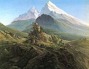
The Watzmann is the third highest mountain in Germany, and the highest peak standing entirely within Germany. Its three main peaks (arrayed on a N-S axis along a ridge line on the taller half of the mountain in the image at right) are Hocheck (2651 m), Mittelspitze (Middle Peak, 2,713m) and Südspitze (South Peak, 2,712m).
The Watzmann massive also includes the Watzmannfrau (Watzmann Wife, also known as Kleiner Watzmann or Small Watzmann), at 2307 m (leftmost peak in image), and the Watzmannkinder (Watzmann Children), five lower peaks in the recess between the main peaks and the Watzmannfrau.
is located below the famous east face of the Watzmann in the Watzmann cirque
and is surrounded by the Watzmanngrat arête
, the Watzmannkindern and the Kleiner Watzmann.
The size of the glacier reduced from around 30 hectares (74.1 acre) in 1820 until it split into a few fields of firn
, but between 1965 and 1980 it advanced significantly again and now has an area of 10.1 hectares (25 acre).
Above and to the west of the icefield lie the remains of a JU 52 transport-bomber that crashed in October 1940.
Amongst the other permanent snow and icefields the Eiskapelle ("Ice Chapel") is the best known due to its easy accessibility from St. Bartholomä. The Eiskapelle may well be the lowest lying permanent snowfield in the Alps. Its lower end is only 930 metres high in the upper Eisbach valley and is about an hour's walk from St. Bartholomä on the Königssee lake. The Eiskapelle is fed by mighty avalanche
s that slide down from the east face of the Watzmann in spring and accumulate in the angle of the rock face. Sometimes a gate-shaped vault forms in the ice at the point where the Eisbach emerges from the Eiskapelle. Before entering there is an urgent warning sig that others have been killed by falling ice.
In the east face itself is another icefield in the so-called Schöllhorn cirque, called the Schöllhorneis, which is crossed by the Kederbach Way (Kederbacher-Weg). The cirque and icefield are named after the Munich citizen, Christian Schöllhorn, who was the first victim on the east face. On 26 May 1890 he fell at the upper end of the icefield into the randkluft
and was fatally injured. Another small nameless snowfield is located several hundred metres below the Mittelspitze also in the east face.
near the small town of Berchtesgaden
up to the Watzmann Hut at 1,928 metres, such as hiking trail 441 from Wimbachbrücke. This is quoted as taking 4 hours, though an experienced hiker can do it in less than 3. One typically spends the night there and then climbs to the summit the next morning. The climb from the hut to the Hocheck peak (2651 m) is quite straightforward, though a "head for heights" is required on the peak. The Hocheck is around 2 hours from the Watzmann Hut. From the Hocheck, hikers can return to the hut or continue and traverse to the Mittelspitze and from there to the Südspitze. The traverse is more challenging, at the easier end of UIAA Class II, and very exposed - though permanent cables along the ridge makes the traverse safer. From the Südspitze, most hikers will not return to the Watzmann Hut but continue to descend into the Wimbachgrieß valley and from there back to Ramsau
. One should estimate 12 to 17 hours for the complete circuit, stable weather conditions are essential as drastic weather change on the ridge between the peaks can be fatal.
 A much more serious and challenging climb is the famous East Face (Watzmann-Ostwand), which rises from the Hirschau peninsula at lake Königssee
to the main peaks in a vertical ascent of around 1800m (the longest wall in the Eastern Alps
). While the easiest routes through the east wall is rated UIAA Class III, the wall has claimed almost 100 lives so far. Difficulties include the length of the climb, route-finding, and deteriorating weather conditions approaching from west, the predominant direction for weather change in the area, difficult to ascertain from the face. A simple emergency shelter has been erected in the wall. Even experienced climbers are advised to hire a local guide for the wall as finding the route can be challenging.
The Watzmann massive also includes the Watzmannfrau (Watzmann Wife, also known as Kleiner Watzmann or Small Watzmann), at 2307 m (leftmost peak in image), and the Watzmannkinder (Watzmann Children), five lower peaks in the recess between the main peaks and the Watzmannfrau.
Watzmann Glacier and other icefields
The Watzmann GlacierWatzmann Glacier
The Watzmann Glacier is one of the five recognised glaciers in Germany. It is located below the famous east face of the Watzmann in the Watzmann cirque and is surrounded by the Watzmanngrat arête, the Watzmannkindern and the Kleiner Watzmann....
is located below the famous east face of the Watzmann in the Watzmann cirque
Cirque
Cirque may refer to:* Cirque, a geological formation* Makhtesh, an erosional landform found in the Negev desert of Israel and Sinai of Egypt*Cirque , an album by Biosphere* Cirque Corporation, a company that makes touchpads...
and is surrounded by the Watzmanngrat arête
Arete
Areté is the term meaning "virtue" or "excellence", from Greek ἈρετήArete may also be used:*as a given name of persons or things:**Queen Arete , a character in Homer's Odyssey.***197 Arete, an asteroid....
, the Watzmannkindern and the Kleiner Watzmann.
The size of the glacier reduced from around 30 hectares (74.1 acre) in 1820 until it split into a few fields of firn
Firn
Firn is partially-compacted névé, a type of snow that has been left over from past seasons and has been recrystallized into a substance denser than névé. It is ice that is at an intermediate stage between snow and glacial ice...
, but between 1965 and 1980 it advanced significantly again and now has an area of 10.1 hectares (25 acre).
Above and to the west of the icefield lie the remains of a JU 52 transport-bomber that crashed in October 1940.
Amongst the other permanent snow and icefields the Eiskapelle ("Ice Chapel") is the best known due to its easy accessibility from St. Bartholomä. The Eiskapelle may well be the lowest lying permanent snowfield in the Alps. Its lower end is only 930 metres high in the upper Eisbach valley and is about an hour's walk from St. Bartholomä on the Königssee lake. The Eiskapelle is fed by mighty avalanche
Avalanche
An avalanche is a sudden rapid flow of snow down a slope, occurring when either natural triggers or human activity causes a critical escalating transition from the slow equilibrium evolution of the snow pack. Typically occurring in mountainous terrain, an avalanche can mix air and water with the...
s that slide down from the east face of the Watzmann in spring and accumulate in the angle of the rock face. Sometimes a gate-shaped vault forms in the ice at the point where the Eisbach emerges from the Eiskapelle. Before entering there is an urgent warning sig that others have been killed by falling ice.
In the east face itself is another icefield in the so-called Schöllhorn cirque, called the Schöllhorneis, which is crossed by the Kederbach Way (Kederbacher-Weg). The cirque and icefield are named after the Munich citizen, Christian Schöllhorn, who was the first victim on the east face. On 26 May 1890 he fell at the upper end of the icefield into the randkluft
Randkluft
A randkluft is the headwall gap between a glacier or snowfield and the adjacent rock face at the back of the cirque or, more loosely, between the rock face and the side of the glacier. It is formed by the melting of ice against warmer rock and may be very deep. During summer therefore, a randkluft...
and was fatally injured. Another small nameless snowfield is located several hundred metres below the Mittelspitze also in the east face.
Climbing
From the North
The best climbing period is June through September, in some years October. The easiest route is to follow hiking trails from the village of RamsauRamsau
Ramsau is the name of several municipalities and towns in Germany, Austria, Switzerland, as well as the traditional German name of the municipality of Ramzová in the Czech Republic.Municipalities named Ramsau include:*Ramsau bei Berchtesgaden, Germany...
near the small town of Berchtesgaden
Berchtesgaden
Berchtesgaden is a municipality in the German Bavarian Alps. It is located in the south district of Berchtesgadener Land in Bavaria, near the border with Austria, some 30 km south of Salzburg and 180 km southeast of Munich...
up to the Watzmann Hut at 1,928 metres, such as hiking trail 441 from Wimbachbrücke. This is quoted as taking 4 hours, though an experienced hiker can do it in less than 3. One typically spends the night there and then climbs to the summit the next morning. The climb from the hut to the Hocheck peak (2651 m) is quite straightforward, though a "head for heights" is required on the peak. The Hocheck is around 2 hours from the Watzmann Hut. From the Hocheck, hikers can return to the hut or continue and traverse to the Mittelspitze and from there to the Südspitze. The traverse is more challenging, at the easier end of UIAA Class II, and very exposed - though permanent cables along the ridge makes the traverse safer. From the Südspitze, most hikers will not return to the Watzmann Hut but continue to descend into the Wimbachgrieß valley and from there back to Ramsau
Ramsau
Ramsau is the name of several municipalities and towns in Germany, Austria, Switzerland, as well as the traditional German name of the municipality of Ramzová in the Czech Republic.Municipalities named Ramsau include:*Ramsau bei Berchtesgaden, Germany...
. One should estimate 12 to 17 hours for the complete circuit, stable weather conditions are essential as drastic weather change on the ridge between the peaks can be fatal.
East Face
Königssee
The Königssee is a lake located in the extreme southeast Berchtesgadener Land district of the German state of Bavaria, near the border with Austria...
to the main peaks in a vertical ascent of around 1800m (the longest wall in the Eastern Alps
Eastern Alps
Eastern Alps is the name given to the eastern half of the Alps, usually defined as the area east of the Splügen Pass in eastern Switzerland. North of the Splügen Pass, the Posterior Rhine forms the border, and south of the pass, the Liro river and Lake Como form the boundary line.-Geography:The...
). While the easiest routes through the east wall is rated UIAA Class III, the wall has claimed almost 100 lives so far. Difficulties include the length of the climb, route-finding, and deteriorating weather conditions approaching from west, the predominant direction for weather change in the area, difficult to ascertain from the face. A simple emergency shelter has been erected in the wall. Even experienced climbers are advised to hire a local guide for the wall as finding the route can be challenging.