
Washington State Route 271
Encyclopedia
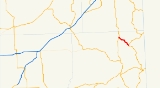
State Route 271 is a 8.48 miles (13.6 km) long state highway
located entirely in Whitman County, Washington
, Washington, United States. The highway begins at a y-intersection
with SR 27 in the northern outskirts of Oakesdale
north to an interchange
with U.S. Route 195 (US 195) southeast of Rosalia
. The highway listed as part of the Palouse Scenic Byway.
with SR 27 in north Oakesdale, traveling northwest past the Oakesdale Cemetery. The highway traverses rolling wheat fields through rural Whitman County, crossing over McCoy and Pine Creeks. The highway parallels a single track
, to the west of the highway, belonging to the Washington and Idaho Railway
, crossing over the line roughly half way to Rosalia. The rail line continues to parallel the highway after crossing it, just on the opposite side of the highway. SR 271 terminates at an interchange with US 195 southeast of Rosalia, however the roadway continues into the town as a county-maintained road. The entirety of the route has been named as part of the Palouse Scenic Byway.
Every year the Washington State Department of Transportation
(WSDOT) conducts a series of surveys on its highways in the state to measure traffic volume. This is expressed in terms of average annual daily traffic (AADT), which is a measure of traffic volume for any average day of the year. In 2009, WSDOT calculated that between 650 and 740 cars travel along the highway on an average day.
predates the road, and was in place since at least 1903. The first roadway to link the two cities first appeared on maps in 1912, and was named the eastern branch of the Inland Empire Highway by 1915. Between 1939 and the 1964 state highway renumbering
, SR 271 was part of Primary State Highway 3.
.
{| class="wikitable"
|-
!scope=col|Location
!scope=col|Mile
!scope=col|Destinations
!scope=col|Notes
|-
|Oakesdale
|0.00
|
|Southern terminus
|-
|
|8.38–8.48
|
|Interchange
, northern terminus
State highway
State highway, state road or state route can refer to one of three related concepts, two of them related to a state or provincial government in a country that is divided into states or provinces :#A...
located entirely in Whitman County, Washington
Whitman County, Washington
Whitman County is a county located in the U.S. state of Washington. As of the 2010 census, the population was 44,776, with the majority living in its largest city, Pullman, home to Washington State University, the state's land-grant university. The county seat is at Colfax.Whitman County was...
, Washington, United States. The highway begins at a y-intersection
3-way junction
A 3-way junction is a type of road junction with three arms. A Y junction generally has 3 arms of equal size...
with SR 27 in the northern outskirts of Oakesdale
Oakesdale, Washington
Oakesdale is a town in Whitman County, Washington, United States. The population was 422 at the 2010 census.-Historical population:* 1890...528* 1900...928* 1910...882* 1920...816* 1930...637* 1940...590* 1950...576* 1960...474* 1970...447...
north to an interchange
Interchange (road)
In the field of road transport, an interchange is a road junction that typically uses grade separation, and one or more ramps, to permit traffic on at least one highway to pass through the junction without directly crossing any other traffic stream. It differs from a standard intersection, at which...
with U.S. Route 195 (US 195) southeast of Rosalia
Rosalia, Washington
Rosalia is a town in Whitman County, Washington, U.S.A. It is an agricultural community in the Palouse region, at an elevation of 2238 feet above sea level. Its population was 550 at the 2010 census.-History:...
. The highway listed as part of the Palouse Scenic Byway.
Route description
SR 271 begins at a y-interchange3-way junction
A 3-way junction is a type of road junction with three arms. A Y junction generally has 3 arms of equal size...
with SR 27 in north Oakesdale, traveling northwest past the Oakesdale Cemetery. The highway traverses rolling wheat fields through rural Whitman County, crossing over McCoy and Pine Creeks. The highway parallels a single track
Single track (rail)
A single track railway is where trains in both directions share the same track. Single track is normally used on lesser used rail lines, often branch lines, where the traffic density is not high enough to justify the cost of building double tracks....
, to the west of the highway, belonging to the Washington and Idaho Railway
Washington and Idaho Railway
The Washington and Idaho Railway is a shortline railroad that operates in the area south of Spokane, Washington, connecting the BNSF Railway at Marshall to Palouse, Washington, Harvard, Idaho, and Moscow, Idaho...
, crossing over the line roughly half way to Rosalia. The rail line continues to parallel the highway after crossing it, just on the opposite side of the highway. SR 271 terminates at an interchange with US 195 southeast of Rosalia, however the roadway continues into the town as a county-maintained road. The entirety of the route has been named as part of the Palouse Scenic Byway.
Every year the Washington State Department of Transportation
Washington State Department of Transportation
The Washington State Department of Transportation , was established in 1905. The agency, led by a Secretary and overseen by the Governor, is a Washington governmental agency that constructs, maintains, and regulates the use of the state's transportation infrastructure...
(WSDOT) conducts a series of surveys on its highways in the state to measure traffic volume. This is expressed in terms of average annual daily traffic (AADT), which is a measure of traffic volume for any average day of the year. In 2009, WSDOT calculated that between 650 and 740 cars travel along the highway on an average day.
History
The rail line, originally belonging to the Northern Pacific RailwayNorthern Pacific Railway
The Northern Pacific Railway was a railway that operated in the west along the Canadian border of the United States. Construction began in 1870 and the main line opened all the way from the Great Lakes to the Pacific when former president Ulysses S. Grant drove in the final "golden spike" in...
predates the road, and was in place since at least 1903. The first roadway to link the two cities first appeared on maps in 1912, and was named the eastern branch of the Inland Empire Highway by 1915. Between 1939 and the 1964 state highway renumbering
1964 state highway renumbering (Washington)
In 1963, a law was passed authorizing a new numbering for sign routes. In 1970 the legislative definitions were changed to use the sign route numbers but renamed state routes...
, SR 271 was part of Primary State Highway 3.
Major intersections
The entire route is located in Whitman CountyWhitman County, Washington
Whitman County is a county located in the U.S. state of Washington. As of the 2010 census, the population was 44,776, with the majority living in its largest city, Pullman, home to Washington State University, the state's land-grant university. The county seat is at Colfax.Whitman County was...
.
{| class="wikitable"
|-
!scope=col|Location
!scope=col|Mile
!scope=col|Destinations
!scope=col|Notes
|-
|Oakesdale
Oakesdale, Washington
Oakesdale is a town in Whitman County, Washington, United States. The population was 422 at the 2010 census.-Historical population:* 1890...528* 1900...928* 1910...882* 1920...816* 1930...637* 1940...590* 1950...576* 1960...474* 1970...447...
|0.00
|
|Southern terminus
|-
|
|8.38–8.48
|
|Interchange
Interchange (road)
In the field of road transport, an interchange is a road junction that typically uses grade separation, and one or more ramps, to permit traffic on at least one highway to pass through the junction without directly crossing any other traffic stream. It differs from a standard intersection, at which...
, northern terminus