
Ware Shoals, South Carolina
Encyclopedia
Ware Shoals is a town in Abbeville
, Greenwood, and Laurens counties in the U.S. state
of South Carolina
, along the Saluda River
. The population was 2,363 at the 2000 census.
The Greenwood County portion of Ware Shoals is part of the Greenwood
Micropolitan Statistical Area, while the Laurens County portion is part of the Greenville
–Mauldin
–Easley
Metropolitan Statistical Area
.
According to the United States Census Bureau
, the town has a total area of 4.0 square miles (10.3 km²), of which, 3.9 square miles (10.0 km²) of it is land and 0.1 square miles (0.3 km²) of it (3.01%) is water.
of 2000, there were 2,363 people, 978 households, and 638 families residing in the town. The population density
was 610.1 people per square mile (235.8/km²). There were 1,126 housing units at an average density of 290.7 per square mile (112.3/km²). The racial makeup of the town was 78.33% White, 20.10% African American, 0.04% Native American, 0.13% Asian, 0.21% from other races
, and 1.18% from two or more races. Hispanic or Latino of any race were 0.38% of the population.
There were 978 households out of which 30.4% had children under the age of 18 living with them, 45.4% were married couples
living together, 16.3% had a female householder with no husband present, and 34.7% were non-families. 31.6% of all households were made up of individuals and 16.9% had someone living alone who was 65 years of age or older. The average household size was 2.37 and the average family size was 2.99.
In the town the population was spread out with 26.6% under the age of 18, 6.4% from 18 to 24, 25.8% from 25 to 44, 21.6% from 45 to 64, and 19.6% who were 65 years of age or older. The median age was 39 years. For every 100 females there were 84.5 males. For every 100 females age 18 and over, there were 80.4 males.
The median income for a household in the town was $29,531, and the median income for a family was $36,800. Males had a median income of $31,335 versus $21,058 for females. The per capita income
for the town was $14,813. About 12.8% of families and 15.5% of the population were below the poverty line, including 16.2% of those under age 18 and 14.4% of those age 65 or over.
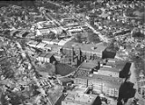
Nat Dial of Laurens County envisioned the possibility of damming this river to power a cotton plant. Dial started the project, but ran out of funds before the power plant was completed. Benjamin D. Riegel bought the project from Dial and founded both the Ware Shoals Manufacturing Company and the town of Ware Shoals in 1902.
The construction of a power plant was completed in 1904, as a prelude to the construction of a state-of-the-art textile mill in 1906. That power plant originally provided for 4,800 horse power. The mill contained 30,000 spindles. By 1916 a new mill was constructed, containing 70,200 spindles and 1,300 looms.
Between 1904 and 1916, the population of Ware Shoals had grown from 2 men employed to maintain the newly constructed power plant, to 2,000. By the 1960s the mill was employing 5,000 people.
The founders of the mill and the original officers of the Ware Shoals Manufacturing Corporation were Benjamin Riegel, president, Benj. D. Riegel, treasurer; James MacEnroe, assistant treasurer; and R. S. Oliver secretary.
MacEnroe was instrumental in the construction of the town's first school, at the cost of $20,000. The mill employed the school's eight teachers and required many of its employees and their children to attend classes.
In 1926 a large school building was constructed to accommodate the Caucasian students. This building is still used today as the Ware Shoals High School and remains one of the oldest school buildings in the use in the state of South Carolina.
In the 1950s, the Emma Maddox School was completed for African American Students. Maddox was a stern disciplinarian and much respected teacher and Principal. The Emma Maddox Building of the current Ware Shoals Elementary School was named in her honor, in recognition of her contributions to the educational, spiritual and civic lives of African Americans in the greater Ware Shoal's area. When public schools were integrated in 1969, Emma Maddox School became the Middle School for all students in the community.
Benjamin Riegel helped organize the town's first church when he brought a Presbyterian preacher, Rev. J. M. Dallas. That first church building was intended as a union church building and the Methodists and Presbyterians used it together, while the Baptists constructed their own facility.
By 1916, the town was as new and modern as any in South Carolina. In addition to the cotton mill and the school, the Ware Shoals Manufacturing Corporation, later known as Riegel Textile Corporation, helped give the town electric lights, water and sewerage and good streets. The mill operated a bank, a railway, an ice factory, a cotton gin and a cotton seed oil mill. A community center was built by the textile company at a cost of $40,000.
"The People's Amusement Hall" is what Benjamin Riegel set out to build, but was so proud of it that he named it the Katherine Hall, in honor of his daughter. Katherine Hall at various times housed or hosted a movie theater, the community library, a Masonic Lodge, a pool hall, a teen canteen as well as showers and dressing rooms for the adjacent public swimming pool.
The mill also operated a department store, or "company store" as was common in mill towns through the South. The store began as a one-room shanty in 1906. By 1920, a newly constructed store was on its way to becoming one of the best and most modern department stores in the state. Here one could find everything from a cradle to a casket. There was a soda fountain where the community members socialized, toy department, pharmacy, candy counter, men's shop, ladies' ready-to-wear section, furniture department, bargain basement, grocery store, and cloth shop. The store's motto was "You can buy in one store anything from a paper and pen to a Ford automobile, from a baby girl's rattle to her wedding dress."
Beginning in the 1940s, "The Big Friendly" began an early shopper loyalty program by conducting a drawing just before Christmas to award an automobile to one lucky patron. "The Big Friendly" remained a central part of life in Ware Shoals until its closing in 1963. It soon became the SEO, or Southern Executive Offices of the Riegel Textile Corporation. With the closing of the mill and the end of Riegel Textile, the town bought the building and located its City Hall in the now-historic building.
Riegel Stadium was built in 1931. The stadium was first used for football games in 1934. Lighting was installed a year later, allowing night games as well. Through the decades, Riegel Stadium has hosted high school teams, textile baseball leagues, and the Negro baseball leagues. In 1954, the stadium hosted an exhibition game between the Cincinnati Red Legs and The Washington Senators.
The town reached a peak in the early 1970s. However, gross mismanagement at the corporate level facilitated the rapid demise in this plant. The mill was then closed in 1985 and Riegel Textile was sold to Mount Vernon Mills.
Great efforts were made by the Administration of Mayor Ken Landreth to revitalize the Town and turn it into a regional Industrial corridor; but the plans were thwarted by the mismanagement of "Landreth Plan", by the succeeding "Rush" Administration. Mayor Sonny Fredericks resigned in May 2010 citing health issues coupled with imminent water and sewer rate increases for town residents.
Abbeville County, South Carolina
Abbeville County is a county located in the U.S. state of South Carolina. In 2010, its population was 25,147. Its county seat is Abbeville. It is the first county in the United States alphabetically.-History:...
, Greenwood, and Laurens counties in the U.S. state
U.S. state
A U.S. state is any one of the 50 federated states of the United States of America that share sovereignty with the federal government. Because of this shared sovereignty, an American is a citizen both of the federal entity and of his or her state of domicile. Four states use the official title of...
of South Carolina
South Carolina
South Carolina is a state in the Deep South of the United States that borders Georgia to the south, North Carolina to the north, and the Atlantic Ocean to the east. Originally part of the Province of Carolina, the Province of South Carolina was one of the 13 colonies that declared independence...
, along the Saluda River
Saluda River
The Saluda River is a principal tributary of the Congaree River, about 200 mi long, in northern and western South Carolina in the United States...
. The population was 2,363 at the 2000 census.
The Greenwood County portion of Ware Shoals is part of the Greenwood
Greenwood, South Carolina
Greenwood is a city in and the county seat of Greenwood County, South Carolina, United States. The population was 22,071 at the 2000 census and had slightly increased to 22,710 according to a 2009 estimate.-Geography:...
Micropolitan Statistical Area, while the Laurens County portion is part of the Greenville
Greenville, South Carolina
-Law and government:The city of Greenville adopted the Council-Manager form of municipal government in 1976.-History:The area was part of the Cherokee Nation's protected grounds after the Treaty of 1763, which ended the French and Indian War. No White man was allowed to enter, though some families...
–Mauldin
Mauldin, South Carolina
Mauldin is a city in Greenville County, South Carolina, United States. The population was 15,224 at the 2000 census. It is a principal city of the Greenville–Mauldin–Easley Metropolitan Statistical Area.-Geography:...
–Easley
Easley, South Carolina
Easley is a city in Pickens County in the U.S. state of South Carolina. It is a principal city of the Greenville–Mauldin–Easley Metropolitan Statistical Area. Most of the city lies in Pickens County, with only a very small portion of the city in Anderson County...
Metropolitan Statistical Area
Greenville-Mauldin-Easley metropolitan area
The Greenville–Mauldin–Easley Metropolitan Statistical Area, as defined by the United States Office of Management and Budget and used by the United States Census Bureau for statistical purpose only, is an area consisting of three counties in Upstate South Carolina, anchored mainly by...
.
Geography
Ware Shoals is located at 34°23′48"N 82°14′42"W (34.396714, -82.244948).According to the United States Census Bureau
United States Census Bureau
The United States Census Bureau is the government agency that is responsible for the United States Census. It also gathers other national demographic and economic data...
, the town has a total area of 4.0 square miles (10.3 km²), of which, 3.9 square miles (10.0 km²) of it is land and 0.1 square miles (0.3 km²) of it (3.01%) is water.
Demographics
As of the censusCensus
A census is the procedure of systematically acquiring and recording information about the members of a given population. It is a regularly occurring and official count of a particular population. The term is used mostly in connection with national population and housing censuses; other common...
of 2000, there were 2,363 people, 978 households, and 638 families residing in the town. The population density
Population density
Population density is a measurement of population per unit area or unit volume. It is frequently applied to living organisms, and particularly to humans...
was 610.1 people per square mile (235.8/km²). There were 1,126 housing units at an average density of 290.7 per square mile (112.3/km²). The racial makeup of the town was 78.33% White, 20.10% African American, 0.04% Native American, 0.13% Asian, 0.21% from other races
Race (United States Census)
Race and ethnicity in the United States Census, as defined by the Federal Office of Management and Budget and the United States Census Bureau, are self-identification data items in which residents choose the race or races with which they most closely identify, and indicate whether or not they are...
, and 1.18% from two or more races. Hispanic or Latino of any race were 0.38% of the population.
There were 978 households out of which 30.4% had children under the age of 18 living with them, 45.4% were married couples
Marriage
Marriage is a social union or legal contract between people that creates kinship. It is an institution in which interpersonal relationships, usually intimate and sexual, are acknowledged in a variety of ways, depending on the culture or subculture in which it is found...
living together, 16.3% had a female householder with no husband present, and 34.7% were non-families. 31.6% of all households were made up of individuals and 16.9% had someone living alone who was 65 years of age or older. The average household size was 2.37 and the average family size was 2.99.
In the town the population was spread out with 26.6% under the age of 18, 6.4% from 18 to 24, 25.8% from 25 to 44, 21.6% from 45 to 64, and 19.6% who were 65 years of age or older. The median age was 39 years. For every 100 females there were 84.5 males. For every 100 females age 18 and over, there were 80.4 males.
The median income for a household in the town was $29,531, and the median income for a family was $36,800. Males had a median income of $31,335 versus $21,058 for females. The per capita income
Per capita income
Per capita income or income per person is a measure of mean income within an economic aggregate, such as a country or city. It is calculated by taking a measure of all sources of income in the aggregate and dividing it by the total population...
for the town was $14,813. About 12.8% of families and 15.5% of the population were below the poverty line, including 16.2% of those under age 18 and 14.4% of those age 65 or over.
History
Ware Shoals is the site of an old water wheel grist mill operated in the early 19th century by William Ware at Rutledge Ford, on the Saluda River.Nat Dial of Laurens County envisioned the possibility of damming this river to power a cotton plant. Dial started the project, but ran out of funds before the power plant was completed. Benjamin D. Riegel bought the project from Dial and founded both the Ware Shoals Manufacturing Company and the town of Ware Shoals in 1902.
The construction of a power plant was completed in 1904, as a prelude to the construction of a state-of-the-art textile mill in 1906. That power plant originally provided for 4,800 horse power. The mill contained 30,000 spindles. By 1916 a new mill was constructed, containing 70,200 spindles and 1,300 looms.
Between 1904 and 1916, the population of Ware Shoals had grown from 2 men employed to maintain the newly constructed power plant, to 2,000. By the 1960s the mill was employing 5,000 people.
The founders of the mill and the original officers of the Ware Shoals Manufacturing Corporation were Benjamin Riegel, president, Benj. D. Riegel, treasurer; James MacEnroe, assistant treasurer; and R. S. Oliver secretary.
MacEnroe was instrumental in the construction of the town's first school, at the cost of $20,000. The mill employed the school's eight teachers and required many of its employees and their children to attend classes.
In 1926 a large school building was constructed to accommodate the Caucasian students. This building is still used today as the Ware Shoals High School and remains one of the oldest school buildings in the use in the state of South Carolina.
In the 1950s, the Emma Maddox School was completed for African American Students. Maddox was a stern disciplinarian and much respected teacher and Principal. The Emma Maddox Building of the current Ware Shoals Elementary School was named in her honor, in recognition of her contributions to the educational, spiritual and civic lives of African Americans in the greater Ware Shoal's area. When public schools were integrated in 1969, Emma Maddox School became the Middle School for all students in the community.
Benjamin Riegel helped organize the town's first church when he brought a Presbyterian preacher, Rev. J. M. Dallas. That first church building was intended as a union church building and the Methodists and Presbyterians used it together, while the Baptists constructed their own facility.
By 1916, the town was as new and modern as any in South Carolina. In addition to the cotton mill and the school, the Ware Shoals Manufacturing Corporation, later known as Riegel Textile Corporation, helped give the town electric lights, water and sewerage and good streets. The mill operated a bank, a railway, an ice factory, a cotton gin and a cotton seed oil mill. A community center was built by the textile company at a cost of $40,000.
"The People's Amusement Hall" is what Benjamin Riegel set out to build, but was so proud of it that he named it the Katherine Hall, in honor of his daughter. Katherine Hall at various times housed or hosted a movie theater, the community library, a Masonic Lodge, a pool hall, a teen canteen as well as showers and dressing rooms for the adjacent public swimming pool.
The mill also operated a department store, or "company store" as was common in mill towns through the South. The store began as a one-room shanty in 1906. By 1920, a newly constructed store was on its way to becoming one of the best and most modern department stores in the state. Here one could find everything from a cradle to a casket. There was a soda fountain where the community members socialized, toy department, pharmacy, candy counter, men's shop, ladies' ready-to-wear section, furniture department, bargain basement, grocery store, and cloth shop. The store's motto was "You can buy in one store anything from a paper and pen to a Ford automobile, from a baby girl's rattle to her wedding dress."
Beginning in the 1940s, "The Big Friendly" began an early shopper loyalty program by conducting a drawing just before Christmas to award an automobile to one lucky patron. "The Big Friendly" remained a central part of life in Ware Shoals until its closing in 1963. It soon became the SEO, or Southern Executive Offices of the Riegel Textile Corporation. With the closing of the mill and the end of Riegel Textile, the town bought the building and located its City Hall in the now-historic building.
Riegel Stadium was built in 1931. The stadium was first used for football games in 1934. Lighting was installed a year later, allowing night games as well. Through the decades, Riegel Stadium has hosted high school teams, textile baseball leagues, and the Negro baseball leagues. In 1954, the stadium hosted an exhibition game between the Cincinnati Red Legs and The Washington Senators.
The town reached a peak in the early 1970s. However, gross mismanagement at the corporate level facilitated the rapid demise in this plant. The mill was then closed in 1985 and Riegel Textile was sold to Mount Vernon Mills.
Great efforts were made by the Administration of Mayor Ken Landreth to revitalize the Town and turn it into a regional Industrial corridor; but the plans were thwarted by the mismanagement of "Landreth Plan", by the succeeding "Rush" Administration. Mayor Sonny Fredericks resigned in May 2010 citing health issues coupled with imminent water and sewer rate increases for town residents.
External links
- Town of Ware Shoals
- Access 15 TV, Laurens County Community Access Channel is the Public, educational, and government accessPublic, educational, and government accessPublic, educational, and government access television, refers to three different cable television specialty channels...
(PEG) cable tv station