
Wapack Range
Encyclopedia
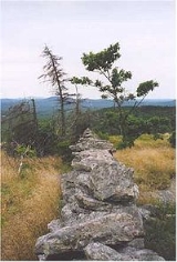
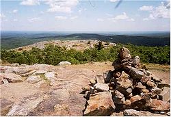
The Wapack Range, sometimes referred to as the Pack Monadnock Range, is a 20-mile range of mountains in south-central New Hampshire
and adjacent Massachusetts
. The range is considered very scenic and rugged with many bare summits and ledges ranging from 1,800 feet to 2,290 feet. The 22 mile Wapack Trail
, one of the oldest interstate hiking trails in the United States
, traverses it. The Wapack Range is also the northern terminus of the 90 mile Midstate Trail.
The range, composed of heavily metamorphosed
schist
and quartzite
, is oriented north-south and is located in the towns of New Ipswich
, Temple
, Sharon
, Peterborough
, and Greenfield, New Hampshire
; and in Massachusetts, the towns of Ashburnham
and Ashby
.
 Notable peaks include, from south to north, Mount Watatic
, Pratt Mountain
, New Ipswich Mountain
, Barrett Mountain
, Kidder Mountain
, Temple Mountain
, Pack Monadnock
and North Pack Monadnock
.
Significant parcels on the Wapack Range have been conserved as state parks, state forests, or properties managed by non-profit land conservation organizations. Miller State Park
, the oldest state park in New Hampshire, is located on Pack Monadnock. A defunct ski area on Temple Mountain was acquired by the state of New Hampshire in 2006 and is also slated for state park status. Conservation efforts on Mount Watatic
have resulted in the protection of the mountain from recent attempts to blast a communications tower road to the summit and open the mountain to housing development. The non-profit Friends of the Wapack have been involved in conservation of the range since 1985.
New Hampshire
New Hampshire is a state in the New England region of the northeastern United States of America. The state was named after the southern English county of Hampshire. It is bordered by Massachusetts to the south, Vermont to the west, Maine and the Atlantic Ocean to the east, and the Canadian...
and adjacent Massachusetts
Massachusetts
The Commonwealth of Massachusetts is a state in the New England region of the northeastern United States of America. It is bordered by Rhode Island and Connecticut to the south, New York to the west, and Vermont and New Hampshire to the north; at its east lies the Atlantic Ocean. As of the 2010...
. The range is considered very scenic and rugged with many bare summits and ledges ranging from 1,800 feet to 2,290 feet. The 22 mile Wapack Trail
Wapack Trail
The Wapack Trail is one of the oldest public, interstate hiking trails in the United States. Opened in 1923, it follows the Wapack Range north-south for , between Mount Watatic in Ashburnham, Massachusetts and North Pack Monadnock mountain in Greenfield, New Hampshire...
, one of the oldest interstate hiking trails in the United States
United States
The United States of America is a federal constitutional republic comprising fifty states and a federal district...
, traverses it. The Wapack Range is also the northern terminus of the 90 mile Midstate Trail.
The range, composed of heavily metamorphosed
Metamorphic rock
Metamorphic rock is the transformation of an existing rock type, the protolith, in a process called metamorphism, which means "change in form". The protolith is subjected to heat and pressure causing profound physical and/or chemical change...
schist
Schist
The schists constitute a group of medium-grade metamorphic rocks, chiefly notable for the preponderance of lamellar minerals such as micas, chlorite, talc, hornblende, graphite, and others. Quartz often occurs in drawn-out grains to such an extent that a particular form called quartz schist is...
and quartzite
Quartzite
Quartzite is a hard metamorphic rock which was originally sandstone. Sandstone is converted into quartzite through heating and pressure usually related to tectonic compression within orogenic belts. Pure quartzite is usually white to gray, though quartzites often occur in various shades of pink...
, is oriented north-south and is located in the towns of New Ipswich
New Ipswich, New Hampshire
New Ipswich is a town in Hillsborough County, New Hampshire, United States. The population was 5,099 at the 2010 census. New Ipswich, situated on the Massachusetts border, includes the villages of Bank, Davis, Gibson Four Corners, Highbridge, New Ipswich Center, Smithville, and Wilder, though these...
, Temple
Temple, New Hampshire
Temple is a town in Hillsborough County, New Hampshire, United States. The population was 1,366 at the 2010 census.- History :Incorporated in 1768, Temple takes its name from colonial governor John Wentworth's lieutenant governor, John Temple.- Geography :...
, Sharon
Sharon, New Hampshire
Sharon is a town in Hillsborough County, New Hampshire, United States. The population was 352 at the 2010 census.-History:Settled in 1738, Sharon was originally a part of Peterborough...
, Peterborough
Peterborough, New Hampshire
Peterborough is a town in Hillsborough County, New Hampshire, United States. The population was 6,284 at the 2010 census. Home to the MacDowell Art Colony, the town is a popular tourist destination....
, and Greenfield, New Hampshire
Greenfield, New Hampshire
Greenfield is a town in Hillsborough County, New Hampshire, United States. The population was 1,749 at the 2010 census. Greenfield is home to the Crotched Mountain Rehabilitation Center, to Greenfield State Park, and to part of the Wapack Trail.- History :...
; and in Massachusetts, the towns of Ashburnham
Ashburnham, Massachusetts
As of the census of 2000, there were 5,546 people, 1,929 households, and 1,541 families residing in the town. The population density was 143.4 people per square mile . There were 2,204 housing units at an average density of 57.0 per square mile...
and Ashby
Ashby, Massachusetts
Ashby is a town in Middlesex County, Massachusetts, United States. The population was 3,120 as of the 2010 census.-Geography:According to the United States Census Bureau, the town has a total area of , of which is land and is water....
.
Mount Watatic
Mount Watatic is a monadnock located on the Massachusetts-New Hampshire border, at the southern end of the Wapack Range of mountains. It lies within Ashburnham, Massachusetts, Ashby, Massachusetts, and New Ipswich, New Hampshire; the Wapack Trail and the Midstate Trail both cross the mountain...
, Pratt Mountain
Pratt Mountain
Pratt Mountain is a monadnock located in south-central New Hampshire within the Wapack Range of mountains. It lies within the town of New Ipswich and is traversed by the Wapack Trail. The subordinate peak, Stony Top, , forms the north shoulder of the mountain...
, New Ipswich Mountain
New Ipswich Mountain
New Ipswich Mountain is a monadnock located in south-central New Hampshire within the Wapack Range of mountains. It lies within the town of New Ipswich and is traversed by the Wapack Trail. Barrett Mountain is located directly to the north along the Wapack ridgeline; Stony Top, a subordinate peak...
, Barrett Mountain
Barrett Mountain
Barrett Mountain is a mountain located in south-central New Hampshire within the Wapack Range of mountains. It lies within the town of New Ipswich and is traversed by the Wapack Trail. Kidder Mountain is located directly to the north along the Wapack ridgeline; New Ipswich Mountain to the south....
, Kidder Mountain
Kidder Mountain
Kidder Mountain is a monadnock located in south-central New Hampshire within the Wapack Range of mountains. It lies within New Ipswich and Temple, New Hampshire just off the Wapack Trail on a side trail. Temple Mountain is located directly to the north along the Wapack ridgeline; Barrett...
, Temple Mountain
Temple Mountain
Temple Mountain is a monadnock located in south-central New Hampshire within the Wapack Range of mountains. It lies within Sharon and Temple, New Hampshire; the Wapack Trail traverses the mountain, and the northern face includes the Temple Mountain Reservation, owned by the state...
, Pack Monadnock
Pack Monadnock
Pack Monadnock or Pack Monadnock Mountain , is the highest peak of the Wapack Range of mountains and the highest point in Hillsborough County, New Hampshire. The mountain, a monadnock, is located in south-central New Hampshire within the towns of Peterborough and Temple. The Wapack Trail and a...
and North Pack Monadnock
North Pack Monadnock
North Pack Monadnock or North Pack Monadnock Mountain is a monadnock located in south-central New Hampshire, at the northern end of the Wapack Range of mountains. It lies within Greenfield and Temple, New Hampshire; the Wapack Trail traverses the mountain. Ledges on the summit offer long views...
.
Significant parcels on the Wapack Range have been conserved as state parks, state forests, or properties managed by non-profit land conservation organizations. Miller State Park
Miller State Park
Miller State Park is the oldest state-run park in New Hampshire, a state in the New England region of the United States. It is mostly located in Peterborough.The park is centered on Pack Monadnock, the 2,290 foot mountain...
, the oldest state park in New Hampshire, is located on Pack Monadnock. A defunct ski area on Temple Mountain was acquired by the state of New Hampshire in 2006 and is also slated for state park status. Conservation efforts on Mount Watatic
Mount Watatic
Mount Watatic is a monadnock located on the Massachusetts-New Hampshire border, at the southern end of the Wapack Range of mountains. It lies within Ashburnham, Massachusetts, Ashby, Massachusetts, and New Ipswich, New Hampshire; the Wapack Trail and the Midstate Trail both cross the mountain...
have resulted in the protection of the mountain from recent attempts to blast a communications tower road to the summit and open the mountain to housing development. The non-profit Friends of the Wapack have been involved in conservation of the range since 1985.