

Wall cloud
Encyclopedia
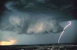
A wall cloud is a large, lowering, and rotating base of a cumulonimbus cloud that potentially forms tornadoes. It is typically beneath the rain-free base (RFB) portion of a deep cumulus cloud
Cumulus cloud
Cumulus clouds are a type of cloud with noticeable vertical development and clearly defined edges. Cumulus means "heap" or "pile" in Latin. They are often described as "puffy" or "cotton-like" in appearance. Cumulus clouds may appear alone, in lines, or in clusters...
(normally cumulonimbus
Cumulonimbus cloud
Cumulonimbus is a towering vertical cloud that is very tall, dense, and involved in thunderstorms and other inclement weather. Cumulonimbus originates from Latin: Cumulus "Heap" and nimbus "rain". It is a result of atmospheric instability. These clouds can form alone, in clusters, or along a cold...
but on rare occasion cumulus congestus), and indicates the area of primary and strongest updraft which condenses into cloud at altitudes lower than that of the ambient cloud base
Cloud base
This article refers to meteorology. For the airborne base of the TV series Captain Scarlet and the Mysterons, see Cloudbase.The cloud base is the lowest altitude of the visible portion of the cloud...
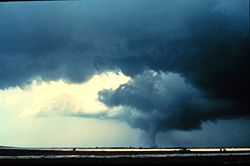
. Most strong tornado
Tornado
A tornado is a violent, dangerous, rotating column of air that is in contact with both the surface of the earth and a cumulonimbus cloud or, in rare cases, the base of a cumulus cloud. They are often referred to as a twister or a cyclone, although the word cyclone is used in meteorology in a wider...
es form from wall clouds.
Genesis
Wall clouds are caused by the ascending and converging inflowInflow (meteorology)
Inflow is the flow of a fluid into a large collection of that fluid. Within meteorology, inflow normally refers to the influx of warmth and moisture from air within the Earth's atmosphere into storm systems. Extratropical cyclones are fed by inflow focused along their cold front and warm fronts...
air of the updraft ingesting moist, rain
Rain
Rain is liquid precipitation, as opposed to non-liquid kinds of precipitation such as snow, hail and sleet. Rain requires the presence of a thick layer of the atmosphere to have temperatures above the melting point of water near and above the Earth's surface...
cooled air from the normally downwind downdraft. In supercell
Supercell
A supercell is a thunderstorm that is characterized by the presence of a mesocyclone: a deep, continuously-rotating updraft. For this reason, these storms are sometimes referred to as rotating thunderstorms...
s, this is the forward flank downdraft (FFD). Since temperature tends to decrease and dew point
Dew point
The dew point is the temperature to which a given parcel of humid air must be cooled, at constant barometric pressure, for water vapor to condense into liquid water. The condensed water is called dew when it forms on a solid surface. The dew point is a saturation temperature.The dew point is...
(moisture content) to increase as the updraft entrains
Entrainment (meteorology)
Entrainment is a phenomenon of the atmosphere which occurs when a turbulent flow captures a non-turbulent flow. It is typically used to refer to the capture of a wind flow of high moisture content, or in the case of tropical cyclones, the capture of drier air....
this air, saturation occurs sooner as the air rises. Wall clouds may form as a descending of the cloud base or may form as rising scud
Scud (cloud)
Scud clouds, a type of fractus cloud, are low, detached, irregular clouds found beneath nimbostratus or cumulonimbus clouds. These clouds are often ragged or wispy in appearance. When caught in the outflow beneath a thunderstorm, scud clouds will often move faster than the storm clouds themselves...
consolidates and organizes.
Structure
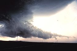
Wall clouds can be anywhere from a fraction of a mile (0.25 km) wide to over five miles (8 km) across, and in the Northern Hemisphere typically form at the south or southwest end of a supercell. Wall clouds form in the inflow region, on the side of the storm coinciding with the direction of the steering winds (deep layer winds through the height of the storm). Rotating wall clouds are visual evidence of a mesocycloneMesocyclone
A mesocyclone is a vortex of air, approximately 2 to 10 miles in diameter , within a convective storm....
.
Associated features
Wall cloud vs. shelf cloud
Occasionally people see a shelf cloud and think they have seen a wall cloud, which is an easy mistake, since an approaching shelf cloud appears to form a wall made of cloud. Generally, a shelf cloud appears on the leading edge of a storm, and a wall cloud will usually be at the rear of the storm, though small rotating wall clouds associated with mesovorticesMesovortices
Mesovortices are small scale rotational features found in convective storms, such as those found in bow echos, supercell thunderstorms and the eyewall of tropical cyclones.-Eyewall mesovortices:...
can occur within the leading edge on rare occasion. Wall clouds will tend to slope in, or toward the precipitation area, whereas shelf clouds as outflow
Outflow
Outflow may refer to:*Capital outflow - an economic term describing capital flowing out of a particular economy.*Bipolar outflow in astronomy represents two continuous flows of gas from the poles of a star....
clouds will jut outward from the storm. Wall clouds are inflow features with (often warm) air moving towards them whereas shelf clouds are an outflow feature with cool air moving away from the storm, often as a gust front.
Supercell and tornado significance
Ted Fujita
was a prominent severe storms researcher. His research at the University of Chicago on severe thunderstorms, tornadoes, hurricanes and typhoons revolutionized knowledge of each.- Biography :Fujita was born in Kitakyūshū, Fukuoka Prefecture, Japan...
associated with tornadoes in tornadic storms. In the special case of a supercell
Supercell
A supercell is a thunderstorm that is characterized by the presence of a mesocyclone: a deep, continuously-rotating updraft. For this reason, these storms are sometimes referred to as rotating thunderstorms...
thunderstorm but also occasionally with intense multicellular thunderstorm
Multicellular thunderstorm
A multicellular thunderstorm cluster is a thunderstorm that is composed of multiple cells, each being at a different stage in the life cycle of a thunderstorm. It looks like several anvils clustered together. A cell is an updraft/downdraft couplet...
s, the wall cloud will often be seen to be rotating. A rotating wall cloud is the area of the thunderstorm that is most likely to produce tornado
Tornado
A tornado is a violent, dangerous, rotating column of air that is in contact with both the surface of the earth and a cumulonimbus cloud or, in rare cases, the base of a cumulus cloud. They are often referred to as a twister or a cyclone, although the word cyclone is used in meteorology in a wider...
es, and the vast majority of intense tornadoes.
Tornadogenesis
Tornadogenesis
Tornadogenesis is the process by which a tornado forms. There are many types of tornadoes, and each type of tornado can have several different methods of formation. Scientific study is ongoing, as some aspects of tornado formation remain a mystery....
is most likely when the wall cloud is persistent with rapid ascension and rotation. The wall cloud typically precedes tornadogenesis by ten to twenty minutes but may be as little as one minute or more than an hour. Often, the degree of ascension and rotation increase markedly shortly before tornadogenesis, and sometimes the wall cloud will descend and "bulk" or "tighten". Tornadic wall clouds tend to have strong, persistent, and warm inflow air. This should be sensible at the surface if one is in the inflow region; in the Northern Hemisphere, this is typically to the south and southeast of the wall cloud. Large tornadoes tend to come from larger, lower wall clouds closer to the back of the rain curtain (providing less visual warning time if you're in the path of an organized storm).
Although it is rotating wall clouds that contain most strong tornadoes, many rotating wall clouds do not produce tornadoes. Absent a low-level boundary, tornadoes very rarely occur without a rear flank downdraft
Rear flank downdraft
The rear flank downdraft or RFD is a region of dry air wrapping around the back of a mesocyclone in a supercell thunderstorm. These areas of descending air are thought to be essential in the production of many supercellular tornadoes...
(RFD), which usually manifests itself visually as a drying out of clouds, called a clear slot or notch. The RFD initiates the tornado, occludes
Occluded front
An occluded front is formed during the process of cyclogenesis when a cold front overtakes a warm front. When this occurs, the warm air is separated from the cyclone center at the Earth's surface...
around the mesocyclone, and when it wraps completely around, cuts off the inflow causing death of the low-level mesocyclone and tornadolysis. Therefore, in most cases, the RFD is responsible for both the birth and the death of a tornado.
Usually, but not always, the dry slot occlusion is visible (assuming one's line of sight is not blocked by precipitation) throughout the tornado life cycle. The wall cloud withers and will often be gone by the time the tornado lifts. If conditions are favorable, then, often even before the original tornado lifts, another wall cloud and occasionally a tornado may form downwind of the old wall cloud, typically to the east or the southeast in the Northern Hemisphere (vice versa in the Southern Hemisphere).
External links
- Wall cloud - AMS Glossary of Meteorology