

Wakakusa, Yamanashi
Encyclopedia
is an area located within the city of Minami-Alps in Yamanashi Prefecture
, Japan
. As of 2003 it has a population of 11,671. The Japanese kanji can be translated as "Young" - "Grass".
and longitude 138° east
. Wakakusa is a relatively flat area with many rice fields and orchards. The Kamanashi River (釜無川)forms its Eastern boundary.
three hamlets—Tōkaichiba (十日市場), Kagami (加賀美), and Terabe (寺部) merged to form a new village called Mitsue (三枝).
After World War II
, Mistue merged with Tōda (籐田), Asabara, and Kagaminakajō (鏡中條) to form the village of Wakakusa.
Wakakusa was independent until 2003 when the city leaders decided to merge with the towns of Shirane, Wakakusa, Kushigata and Kōsai, and the villages of Hatta and Ashiyasu, all from Nakakoma District
, to form the city of Minami-Alps.
- Founded in 806 A.D., this temple follows the Nichiren
sect of Japanese Buddhism
.
Anyoji- This temple follows the Shingon sect of Buddhism. It was founded in 1234 A.D.
760 years ago in the Kamakura
-era, a distinguished priest, Saint Kakuou, was living in this area. Before he was invited to live here, he had belonged to the famous Koyason temple in Kii region. On January 10, according to the lunar calendar, he heard an oracle that suggested he carve a statue. He made the statue, and it was deified. People prayed to it day and night.
One day, during the rice-planting season in the same year, a rampaging horse was causing great trouble to the farmers. From nowhere, a boy of 15 or 16 suddenly appeared and grabbed the bit of the horse. Miraculously, the horse was calmed down, and then the farmers could do the rice-planting peacefully.
A little after this incident, some people happened to notice that the statue had some mud attached to its feet. People believed that the statue had transformed into the boy and helped the farmers; the guardian deity got the mud when he was dealing with the horse. This mythical story was told from mouth to mouth and people deepened their belief in the statue.
Since then, people have started to call it "Hana-tori Statue" which means, "A statue that leads horses and cows by their noses". They have also started to hold an annual festival on January 10, the day when the priest received the oracle. It is said that people from all over Yamanashi came to visit the festival en masse as the rumor of the mythic statue in Tokaichi spread.
Geologically speaking, located at the end of the Midai river alluvial fan, this region around Tokaichi is suitable for both rice cultivation and dry field farming. In addition to this, the region is close to key agricultural and forestry places: Takata, a paddy region in former Tatomi and Kosai towns; Genkata, a dry field farming region in former Shirane town; and Nekata, a forestry region in Masuho town. All of these geological conditions of Tokaichi made it become a big market place where farm products and agricultural machines were exchanged or sold. They say that the history of the market dates back to the Edo era.
Now, you can see various things showcased at the Tokaichi market: Darumas-round, red-painted good luck dolls in the shape of Bodhidharma; objects that will bring good fortune; wooden products such as ladders, mallets, mortars and mauls; garden plants and prepared food.
Yamanashi Prefecture
is a prefecture of Japan located in the Chūbu region of the island of Honshū. The capital is the city of Kōfu.-Pre-history to the 14th century:People have been living in the Yamanashi area for about 30,000 years...
, Japan
Japan
Japan is an island nation in East Asia. Located in the Pacific Ocean, it lies to the east of the Sea of Japan, China, North Korea, South Korea and Russia, stretching from the Sea of Okhotsk in the north to the East China Sea and Taiwan in the south...
. As of 2003 it has a population of 11,671. The Japanese kanji can be translated as "Young" - "Grass".
Geography
Wakakusa is located approximately 12 kilometers from Kofu. It covers an area of 10.29 square kilometers and lies on latitude 35° north35th parallel north
The 35th parallel north is a circle of latitude that is 35 degrees north of the Earth's equatorial plane. It crosses Africa, the Mediterranean Sea, Asia, the Pacific Ocean, North America and the Atlantic Ocean....
and longitude 138° east
138th meridian east
The meridian 138° east of Greenwich is a line of longitude that extends from the North Pole across the Arctic Ocean, Asia, the Pacific Ocean, Australasia, the Indian Ocean, the Southern Ocean, and Antarctica to the South Pole....
. Wakakusa is a relatively flat area with many rice fields and orchards. The Kamanashi River (釜無川)forms its Eastern boundary.
History
Long ago there were many independent hamlets between the Kamanashi River and the Japan Alps. At the beginning of the Meiji RestorationMeiji Restoration
The , also known as the Meiji Ishin, Revolution, Reform or Renewal, was a chain of events that restored imperial rule to Japan in 1868...
three hamlets—Tōkaichiba (十日市場), Kagami (加賀美), and Terabe (寺部) merged to form a new village called Mitsue (三枝).
After World War II
World War II
World War II, or the Second World War , was a global conflict lasting from 1939 to 1945, involving most of the world's nations—including all of the great powers—eventually forming two opposing military alliances: the Allies and the Axis...
, Mistue merged with Tōda (籐田), Asabara, and Kagaminakajō (鏡中條) to form the village of Wakakusa.
Wakakusa was independent until 2003 when the city leaders decided to merge with the towns of Shirane, Wakakusa, Kushigata and Kōsai, and the villages of Hatta and Ashiyasu, all from Nakakoma District
Nakakoma District, Yamanashi
is a district located in Yamanashi, Japan.As of 2006, the district has an estimated population of 16,273. The total area is 9.15 km².The district has only one town.*Shōwa-District Timeline:...
, to form the city of Minami-Alps.
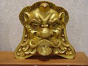
Devil's Head Tile
Wakakusa has a long tradition of tilemaking. Long ago the Devil's Head adorned the cornices of many houses in the village. It said that face kept the evil spirits away.Education
Wakakusa contains four schools:- Wakakusa Elementary School (若草小学校)
- South Wakakusa Elementary School (若草南小学校)
- Wakakusa Junior High School (若草中学校)
- Pitagoras International School (Brazilian)
Temples
Hōzen-jiHozen-ji
was founded in 806 AD in Wakakusa, Nakakoma District, Japan . This temple follows the Shingon sect of Japanese Buddhism.- See also :...
- Founded in 806 A.D., this temple follows the Nichiren
Nichiren
Nichiren was a Buddhist monk who lived during the Kamakura period in Japan. Nichiren taught devotion to the Lotus Sutra, entitled Myōhō-Renge-Kyō in Japanese, as the exclusive means to attain enlightenment and the chanting of Nam-Myōhō-Renge-Kyō as the essential practice of the teaching...
sect of Japanese Buddhism
Buddhism
Buddhism is a religion and philosophy encompassing a variety of traditions, beliefs and practices, largely based on teachings attributed to Siddhartha Gautama, commonly known as the Buddha . The Buddha lived and taught in the northeastern Indian subcontinent some time between the 6th and 4th...
.
Anyoji- This temple follows the Shingon sect of Buddhism. It was founded in 1234 A.D.
Hot Springs
Yu-Yu Furei Park is located in east-central Wakakusa. In addition to a large municipal park the area also contains a Hot Spring.Tōkaichi Festival
The Tōkaichi festival (十日市) is the most famous festival in Wakakusa. It occurs every year on 10 February.760 years ago in the Kamakura
Kamakura period
The is a period of Japanese history that marks the governance by the Kamakura Shogunate, officially established in 1192 in Kamakura by the first shogun Minamoto no Yoritomo....
-era, a distinguished priest, Saint Kakuou, was living in this area. Before he was invited to live here, he had belonged to the famous Koyason temple in Kii region. On January 10, according to the lunar calendar, he heard an oracle that suggested he carve a statue. He made the statue, and it was deified. People prayed to it day and night.
One day, during the rice-planting season in the same year, a rampaging horse was causing great trouble to the farmers. From nowhere, a boy of 15 or 16 suddenly appeared and grabbed the bit of the horse. Miraculously, the horse was calmed down, and then the farmers could do the rice-planting peacefully.
A little after this incident, some people happened to notice that the statue had some mud attached to its feet. People believed that the statue had transformed into the boy and helped the farmers; the guardian deity got the mud when he was dealing with the horse. This mythical story was told from mouth to mouth and people deepened their belief in the statue.
Since then, people have started to call it "Hana-tori Statue" which means, "A statue that leads horses and cows by their noses". They have also started to hold an annual festival on January 10, the day when the priest received the oracle. It is said that people from all over Yamanashi came to visit the festival en masse as the rumor of the mythic statue in Tokaichi spread.
Geologically speaking, located at the end of the Midai river alluvial fan, this region around Tokaichi is suitable for both rice cultivation and dry field farming. In addition to this, the region is close to key agricultural and forestry places: Takata, a paddy region in former Tatomi and Kosai towns; Genkata, a dry field farming region in former Shirane town; and Nekata, a forestry region in Masuho town. All of these geological conditions of Tokaichi made it become a big market place where farm products and agricultural machines were exchanged or sold. They say that the history of the market dates back to the Edo era.
Now, you can see various things showcased at the Tokaichi market: Darumas-round, red-painted good luck dolls in the shape of Bodhidharma; objects that will bring good fortune; wooden products such as ladders, mallets, mortars and mauls; garden plants and prepared food.