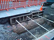
Waihorotiu Stream
Encyclopedia

Auckland City
Auckland City was the city and local authority covering the Auckland isthmus and most of the islands of the Hauraki Gulf, in the North Island of New Zealand. On 1 November 2010 it was amalgamated into the wider Auckland Region under the authority of the new Auckland Council...
, New Zealand
New Zealand
New Zealand is an island country in the south-western Pacific Ocean comprising two main landmasses and numerous smaller islands. The country is situated some east of Australia across the Tasman Sea, and roughly south of the Pacific island nations of New Caledonia, Fiji, and Tonga...
, which has long since been covered over and made to disappear by the increasing urbanisation of the area.
History
Originally, it was an open stream starting out in a gully (now Myers ParkMyers Park (Auckland)
Myers Park is a narrow park in central Auckland, New Zealand, running parallel to the upper part of Queen Street. It is characterised by steep, grassed slopes and canopied with a mixture of large exotic and native trees, including an alley of large palm trees...
) before flowing through a swampy area (now Aotea Square
Aotea Square
Aotea Square is a large paved public area in the CBD, of Auckland, New Zealand. Officially opened in 1979 by Sir Dove-Myer Robinson next to Queen Street, it is used for open-air concerts and gatherings, and markets and political rallies....
) and then down the centre of what was to become Queen Street
Queen Street, Auckland
Queen Street is the major commercial thoroughfare in the Auckland CBD, Auckland, New Zealand's main population centre. It starts at Queens Wharf on the Auckland waterfront, adjacent to the Britomart Transport Centre and the Downtown Ferry Terminal, and runs uphill for almost three kilometres in a...
. Children used the tidal creek to fish for eels, and it provided drinking water for both Maori villages and the first European colonists of Auckland.
With increasing settlement in Auckland, much of which relocated to the stream after a fire in the Shortland Street area, it became little more than an open sewer before being first canalised and then bricked over around the middle of the 19th century by a city engineer, Mr Ligar, after the 'Ligar Canal' threatened to collapse from the flows. Because of its unsanitary conditions, it had been called "an abomination, a pestiferous ditch, and the receptacle of every imaginable filth".
Water percolating through the soil under Myers Park still runs into the old sewers under Queen Street
Queen Street, Auckland
Queen Street is the major commercial thoroughfare in the Auckland CBD, Auckland, New Zealand's main population centre. It starts at Queens Wharf on the Auckland waterfront, adjacent to the Britomart Transport Centre and the Downtown Ferry Terminal, and runs uphill for almost three kilometres in a...
to the sea, discharging under the Ferry Building.
In 2011, a local artist proposed that, as part of the Council's city centre masterplan, the stream be uncovered and become a centrepiece of a more people-friendly inner city.
In Maori mythology, the stream is the home of Horotiu, a local Taniwha
Taniwha
In Māori mythology, taniwha are beings that live in deep pools in rivers, dark caves, or in the sea, especially in places with dangerous currents or deceptive breakers...
(roughly speaking, a local nature spirit).
External links
- From stream to sewer (from the Auckland CityAuckland CityAuckland City was the city and local authority covering the Auckland isthmus and most of the islands of the Hauraki Gulf, in the North Island of New Zealand. On 1 November 2010 it was amalgamated into the wider Auckland Region under the authority of the new Auckland Council...
Council website)

