

Vrcin
Encyclopedia
| Врчин Vrčin |
|
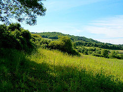 Only 20km from the capital center, Vrčin is a peaceful village with stunning countryside |
|
| Country Country A country is a region legally identified as a distinct entity in political geography. A country may be an independent sovereign state or one that is occupied by another state, as a non-sovereign or formerly sovereign political division, or a geographic region associated with a previously... : |
|
| Subdivision Subdivisions of Serbia The territorial organization of Serbia is regulated by the Law on Territorial Organization, adopted by the National Assembly of Serbia on 29 December 2007... : |
City of Belgrade Belgrade Belgrade is the capital and largest city of Serbia. It is located at the confluence of the Sava and Danube rivers, where the Pannonian Plain meets the Balkans. According to official results of Census 2011, the city has a population of 1,639,121. It is one of the 15 largest cities in Europe... , Grocka Grocka Grocka is a suburban neighborhood and one of 17 municipalities which constitute the City of Belgrade, the capital of Serbia.- Location :... |
| Location Location (geography) The terms location and place in geography are used to identify a point or an area on the Earth's surface or elsewhere. The term 'location' generally implies a higher degree of can certainty than "place" which often has an ambiguous boundary relying more on human/social attributes of place identity... : |
40|N|20|36|E |
| Population Population A population is all the organisms that both belong to the same group or species and live in the same geographical area. The area that is used to define a sexual population is such that inter-breeding is possible between any pair within the area and more probable than cross-breeding with individuals... : 2002 |
9,328 |
| Area code: | +381(0)11 |
| Postal code Postal code A postal code is a series of letters and/or digits appended to a postal address for the purpose of sorting mail. Once postal codes were introduced, other applications became possible.In February 2005, 117 of the 190 member countries of the Universal Postal Union had postal code systems... : |
11224 |
| License plates: | BG |
Vrčin (Serbian
Serbian language
Serbian is a form of Serbo-Croatian, a South Slavic language, spoken by Serbs in Serbia, Bosnia and Herzegovina, Montenegro, Croatia and neighbouring countries....
Cyrillic: Врчин) is a suburban settlement of Belgrade
Belgrade
Belgrade is the capital and largest city of Serbia. It is located at the confluence of the Sava and Danube rivers, where the Pannonian Plain meets the Balkans. According to official results of Census 2011, the city has a population of 1,639,121. It is one of the 15 largest cities in Europe...
, the capital of Serbia
Serbia
Serbia , officially the Republic of Serbia , is a landlocked country located at the crossroads of Central and Southeast Europe, covering the southern part of the Carpathian basin and the central part of the Balkans...
. It is located in Belgrade's municipality of Grocka
Grocka
Grocka is a suburban neighborhood and one of 17 municipalities which constitute the City of Belgrade, the capital of Serbia.- Location :...
.
Geography
Vrčin is located southeast of the AvalaAvala
Avala is a mountain in Serbia, overlooking Belgrade. It is situated in the south-eastern corner of the city and provides a great panoramic view to Belgrade, Vojvodina and Šumadija, as the surrounding area on all sides is mostly a lowlands...
mountain, in the central-eastern part of the municipality, 20 km southeast of Belgrade and 14 km west of the municipal seat of Grocka. It is situated in the spring area of the Bolečica
Bolecica
The Bolečica is a short river in north-central Serbia, a 12 km-long right tributary to the Danube. During its entire flow it runs through the suburban section of Belgrade and despite being short it flows through the three Belgrade's municipalities, next to the half dozen of suburbs of Belgrade ...
river and it is a major crossroad being located on the railway Belgrade-Požarevac
Požarevac
Požarevac is a city and municipality in eastern Serbia. It is the administrative center of the Braničevo District of Serbia...
, the highway Belgrade-Niš
Niš
Niš is the largest city of southern Serbia and third-largest city in Serbia . According to the data from 2011, the city of Niš has a population of 177,972 inhabitants, while the city municipality has a population of 257,867. The city covers an area of about 597 km2, including the urban area,...
, regional road connecting the highway and the road of Smederevski put (through Zaklopača) and another one connecting the highway and the Belgrade-Kragujevac
Kragujevac
Kragujevac is the fourth largest city in Serbia, the main city of the Šumadija region and the administrative centre of Šumadija District. It is situated on the banks of the Lepenica River...
road.
Neighborhoods
Vrčin has several neighborhoods of its own. They can be roughly divided in two sections, north and south of the highway.North section:
- Cerje (Церје), southernmost extension of this section, not connected to the rest of Vrčin in urban sense. It is named after cer, Turkey oakTurkey OakQuercus cerris, the Turkey oak is an oak native to southern Europe and Asia Minor. It is the type species of Quercus sect. Cerris, a section of the genus characterised by shoot buds surrounded by soft bristles, bristle-tipped leaf lobes, and acorns that usually mature in 18...
. - Donja Mala (Доња Мала, "lower alley"), constitutes bulk of the northern section.
- Jankovići (Јанковићи), easternmost section, which makes urban connection to Zaklopača. Named after a family surname.
- Tranšped (Траншпед), northern extension, closest to Belgrade, named after "Tranšped" company.
South section:
- Avramovići (Аврамовићи), northern section, named after a family surname.
- Bajića Kraj (Бајића Крај), eastern section, named after a family surname.
- Carino Naselje (Царино Насеље), south-eastern extension, along the highway.
- Feroplast (Феропласт), after the "Feroplast" company.
- Gornja Mala (Горња Мала, "upper alley"), central part of the entire neighborhood.
- Malo Polje (Мало Поље, "little field"), south-western extension.
- Orlovica (Орловица, "eagle hill").
- Pobrđani (Побрђани, "hilly places"), central-south extension.
- Ravnine (Равнине, "flat fields"), southernmost extension.
Economy
Despite recent development of workshops and the commercial sector (including building of a shopping mall in the center of the settlement), the economy is mostly based on agriculture.Politics
Vrčin was the seat of its own municipality which was disbanded and incorporated into the municipality of Grocka. From time to time, a motions of separating Vrčin from Grocka again appear in the public, due to the distance from its municipal seat and a fact that it is more populous than Grocka. Most recent idea is that Vrčin and several settlement from the VoždovacVoždovac
Voždovac is an urban neighborhood and one of 17 municipalities which constitute the City of Belgrade, the capital of Serbia.- Location :...
municipality (Zuce
Zuce
Zuce is a suburban settlement of Belgrade, the capital of Serbia. It is located in Belgrade's municipality of Voždovac.- Location and geography :...
, Pinosava
Pinosava
Pinosava is a small town and a suburban settlement of Belgrade, the capital of Serbia. It is located in Belgrade's municipality of Voždovac.- Location :...
, Ripanj
Ripanj
Ripanj is a suburban settlement of Belgrade, the capital of Serbia. It is located in Belgrade's municipality of Voždovac...
, Beli Potok
Beli Potok
Beli Potok is a small town and a suburban settlement of Belgrade, the capital of Serbia. It is located in Belgrade's municipality of Voždovac.- Location :...
) create a new, sub-Avala
Avala
Avala is a mountain in Serbia, overlooking Belgrade. It is situated in the south-eastern corner of the city and provides a great panoramic view to Belgrade, Vojvodina and Šumadija, as the surrounding area on all sides is mostly a lowlands...
n municipality of Avalski Venac
Avalski Venac
Avalski Venac is a proposed municipality of the City of Belgrade, the capital of Serbia.- Movement :Movement for creation of the municipality began in 1996 and was enhanced since 2002 and successful campaigning for the re-creation of the municipality of Surčin, which split from the municipality of...
.
Population
Vrčin is statistically classified as a rural settlement (village) and officially is the second most populous settlement in the municipality (Census 2002; after Kaluđerica but before municipal seat of Grocka). However, unofficial estimates including number of refugees (not counted in the official censusCensus
A census is the procedure of systematically acquiring and recording information about the members of a given population. It is a regularly occurring and official count of a particular population. The term is used mostly in connection with national population and housing censuses; other common...
reports) also put Leštane
Leštane
Leštane is a suburban settlement of Belgrade, the capital of Serbia. It is located in the municipality of Grocka.- Location :Leštane is located 15 km east of Belgrade, originally further away from the major roads...
before Vrčin.
Vrčin extends on both sides of the highway (originally developed from the western side), the eastern extension colloquially being named Tranšped (Cyrillic: Траншпед). This area forms a continuous build-up area with Zaklopača. Vrčin experiences a steady growth of population:
- 1921 - 3,470
- 1948 - 5,040
- 1953 - 5,342
- 1961 - 6,042
- 1971 - 6,263
- 1981 - 7,327
- 1991 - 7,589 (de facto)
- 1991 - 8,034 (de jure)
- 2002 - 8,667 (de facto)
- 2002 - 9,328 (de jure)
Sources
- Jovan Đ. Marković (1990): Enciklopedijski geografski leksikon Jugoslavije; Svjetlost-Sarajevo; ISBN 86-01-02651-6