
Uxbridge Road tube station
Encyclopedia
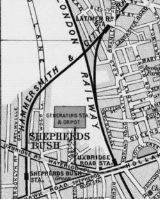
Uxbridge Road was a London Underground
station on a branch of the Metropolitan Line
. It was located at the eastern end of the Uxbridge Road
in Shepherd's Bush, west London
, UK
, just before the start of Holland Park Avenue
, a short distance from Shepherd's Bush
station on the Central Line
. The station entrance was situated on the site of the present-day Holland Park Roundabout
.
Uxbridge Road station – and the branch line – closed on 21 October 1940 during World War II
, when the West London Line
was put out of service by German bombs
.
northwards and joined the Metropolitan Line branch from Hammersmith (today's Hammersmith & City Line
) just south of Latimer Road
station.
Southbound Metropolitan Line services from Uxbridge Road usually terminated at Addison Road as did northbound District Line
services from Earl's Court
station; however, some services ran through from Latimer Road to Earl's Court, thus forming the so-called Middle Circle
.
Although Uxbridge Road station and its branch were closed in 1940, they continued to appear on the Underground map
until 1947. The track formation towards Latimer Road was obliterated by the construction of the M41 motorway in the late 1960s.
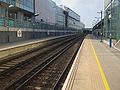
, a new mainline and London Overground
station named Shepherd's Bush
opened in 2008, on part of the site of the original Uxbridge Road station site as an interchange with Shepherd's Bush Central Line station.
London Underground
The London Underground is a rapid transit system serving a large part of Greater London and some parts of Buckinghamshire, Hertfordshire and Essex in England...
station on a branch of the Metropolitan Line
Metropolitan Line
The Metropolitan line is part of the London Underground. It is coloured in Transport for London's Corporate Magenta on the Tube map and in other branding. It was the first underground railway in the world, opening as the Metropolitan Railway on 10 January 1863...
. It was located at the eastern end of the Uxbridge Road
Uxbridge Road
Uxbridge Road is the name of the A4020 road in London. It starts at Shepherd's Bush Green and goes west towards Uxbridge. It passes through Acton, Ealing Broadway and Hanwell....
in Shepherd's Bush, west London
London
London is the capital city of :England and the :United Kingdom, the largest metropolitan area in the United Kingdom, and the largest urban zone in the European Union by most measures. Located on the River Thames, London has been a major settlement for two millennia, its history going back to its...
, UK
United Kingdom
The United Kingdom of Great Britain and Northern IrelandIn the United Kingdom and Dependencies, other languages have been officially recognised as legitimate autochthonous languages under the European Charter for Regional or Minority Languages...
, just before the start of Holland Park Avenue
Holland Park Avenue
Holland Park Avenue is a street located in the Royal Borough of Kensington and Chelsea, in west central London in England. The street runs from Notting Hill Gate in the east to the Holland Park Roundabout in the west, and forms a part of the old west road connecting London with Oxford and the west...
, a short distance from Shepherd's Bush
Shepherd's Bush tube station (Central Line)
Shepherd's Bush is a London Underground station in the district of Shepherd's Bush, which is located in west London, England, United Kingdom. The station is on the Central Line, between and stations, and it lies in Travelcard Zone 2....
station on the Central Line
Central Line
The Central line is a London Underground line, coloured red on the tube map. It is a deep-level "tube" line, running east-west across London, and, at , has the greatest total length of track of any line on the Underground. Of the 49 stations served, 20 are below ground...
. The station entrance was situated on the site of the present-day Holland Park Roundabout
Roundabout
A roundabout is the name for a road junction in which traffic moves in one direction around a central island. The word dates from the early 20th century. Roundabouts are common in many countries around the world...
.
Uxbridge Road station – and the branch line – closed on 21 October 1940 during World War II
World War II
World War II, or the Second World War , was a global conflict lasting from 1939 to 1945, involving most of the world's nations—including all of the great powers—eventually forming two opposing military alliances: the Allies and the Axis...
, when the West London Line
West London Line
The West London Line is a short railway in inner West London which links lines at in the south to lines near Willesden Junction in the north. It has always been an important cross-London link especially for freight services...
was put out of service by German bombs
The Blitz
The Blitz was the sustained strategic bombing of Britain by Nazi Germany between 7 September 1940 and 10 May 1941, during the Second World War. The city of London was bombed by the Luftwaffe for 76 consecutive nights and many towns and cities across the country followed...
.
History
This branch of the Metropolitan Line opened in 1864 and ran north from Addison Road (now Kensington (Olympia)) station following the mainline tracks of the West London RailwayWest London Line
The West London Line is a short railway in inner West London which links lines at in the south to lines near Willesden Junction in the north. It has always been an important cross-London link especially for freight services...
northwards and joined the Metropolitan Line branch from Hammersmith (today's Hammersmith & City Line
Hammersmith & City Line
The Hammersmith & City line is a subsurface London Underground line. It connects Hammersmith in the west with Barking in the east, running through the northern part of central London. It is coloured salmon pink on the Tube map...
) just south of Latimer Road
Latimer Road tube station
Latimer Road Station is a London Underground station in North Kensington on the Circle and Hammersmith & City lines between Wood Lane and Ladbroke Grove stations...
station.
Southbound Metropolitan Line services from Uxbridge Road usually terminated at Addison Road as did northbound District Line
District Line
The District line is a line of the London Underground, coloured green on the Tube map. It is a "sub-surface" line, running through the central area in shallow cut-and-cover tunnels. It is the busiest of the sub-surface lines. Out of the 60 stations served, 25 are underground...
services from Earl's Court
Earl's Court tube station
Earl's Court tube station is a London Underground station in Earls Court. The station is located between Earls Court Road and Warwick Road . It is on the boundary of Travelcard Zone 1 and 2 and is in both zones....
station; however, some services ran through from Latimer Road to Earl's Court, thus forming the so-called Middle Circle
Middle Circle
The Middle Circle was a railway route in London which operated in the late 19th and early 20th centuries over tracks which are now mainly part of the London Underground...
.
Although Uxbridge Road station and its branch were closed in 1940, they continued to appear on the Underground map
Tube map
The Tube map is a schematic transit map representing the lines and stations of London's rapid transit railway systems, namely the London Underground , the Docklands Light Railway and London Overground....
until 1947. The track formation towards Latimer Road was obliterated by the construction of the M41 motorway in the late 1960s.
Resurrection of station
As part of the redevelopment of the White City siteWestfield London
Westfield London is a shopping centre in White City in the London Borough of Hammersmith and Fulham. The centre was developed by the Westfield Group at a cost of £1.6bn,...
, a new mainline and London Overground
London Overground
London Overground is a suburban rail network in London and Hertfordshire. It has been operated by London Overground Rail Operations since 2007 as part of the National Rail network, under the franchise control and branding of Transport for London...
station named Shepherd's Bush
Shepherd's Bush railway station
Shepherd's Bush station is a railway station located in the district of Shepherd's Bush in west London, England, UK. It opened in 2008 on the West London Line and is served by London Overground and Southern rail services...
opened in 2008, on part of the site of the original Uxbridge Road station site as an interchange with Shepherd's Bush Central Line station.
See also
- Shepherd's Bush stationsShepherd's Bush stationsShepherd's Bush is an area of west London, United Kingdom, which has been served by a number of London Underground and commuter rail stations over past 150 years, many of which have had similar names...
External links
- Uxbridge Road, SubBrit disused stations project
- Shepherd's Bush 1st site and 2nd site. Sites of predecessor stations, 1844 and 1864-9. SubBrit disused stations project.
- Details of new transport infrastructure