
Uvac
Encyclopedia
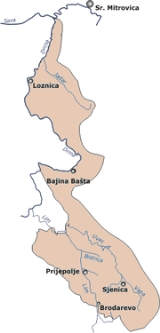
The Uvac is the river in southwestern Serbia
and Republika Srpska
, 119 km long right and major tributary of the Lim
, loosely making the northern border of the Sandžak
/Raška
region. Before it empties into the Lim, for a 10 kilometers it forms the border between Serbia and Bosnia and Herzegovina.
 The Uvac originates in the Pešter
plateau from the Ninaja mountain, as Rasanska reka (Cyrillic: Расанска река). The stream curves around the Ninaja and Pometenik mountains, next to the villages of Tuzinje, Rasno, Dragojloviće and Gradac, where it meets Brnjička reka (Cyrillic: Брњичка река), enters the Sjenica
depression and continues on depression eastern border as the Vapa (Cyrillic: Вапа), which is 25 kilometers long and drains an area of 496 km².
The river passes next to the villages of Gornja Vapa, Donja Vapa, Čedovo and Krstac, where the Vapa receives from the left the short river Uvac, which originates on the Ozren
mountain, and gives name to the downstream course of the river.
region where it flows in a deep, canyon-like valley, where it receives the Kladnica river from the right and generates lots of power, which is used for three powerful hydroelectric power stations, each one with big artificial lake: Bistrica with Lake Radoinja, Kokin Brod with Lake Zlatar (7,3 km², altitude 400 m, depth 40 m) and Sjenica with Lake Sjenica.
In the lowest part of its course, The Uvac flows between the Zlatar and Zlatibor
mountains, next to the villages of Kokin Brod and Radoinja until it reaches the Bosnian border and Varda mountain, makes a sharp, elbow turn to the south and after a short flow next to the villages of Bjelušine and Uvac (both on Bosnian side), the Uvac empties into the Lim, north of the city of Priboj
.
The Uvac drains an area of 1,310 km², belongs to the Black Sea
drainage basin
, and its not navigable. Its average discharge at the mouth is 18 m³/s.
Serbia
Serbia , officially the Republic of Serbia , is a landlocked country located at the crossroads of Central and Southeast Europe, covering the southern part of the Carpathian basin and the central part of the Balkans...
and Republika Srpska
Republika Srpska
Republika Srpska is one of two main political entities of Bosnia and Herzegovina, the other being the Federation of Bosnia and Herzegovina...
, 119 km long right and major tributary of the Lim
Lim River
The Lim is a river flowing through Montenegro, Albania, Serbia and Bosnia and Herzegovina. long, it's the right and the longest tributary of the Drina.- Montenegro and Serbia :...
, loosely making the northern border of the Sandžak
Sandžak
Sandžak also known as Raška is a historical region lying along the border between Serbia and Montenegro...
/Raška
Raška (region)
Raška is a region in south-central Serbia and northern Montenegro. It is mostly situated in the Raška District. The southern part of Raška is also known as Sandžak and is divided between Serbia and Montenegro....
region. Before it empties into the Lim, for a 10 kilometers it forms the border between Serbia and Bosnia and Herzegovina.
Upper course
Pešter
thumb|right|[[Northern Lapwing]]Pešter or Pešterska visoravan is a karst plateau in southwestern Serbia, in the Raška region. It lies at the altitude of 900–1200 meters. The territory of the plateau is mostly located in the municipality of Sjenica, with parts belonging to Novi Pazar and Tutin...
plateau from the Ninaja mountain, as Rasanska reka (Cyrillic: Расанска река). The stream curves around the Ninaja and Pometenik mountains, next to the villages of Tuzinje, Rasno, Dragojloviće and Gradac, where it meets Brnjička reka (Cyrillic: Брњичка река), enters the Sjenica
Sjenica
Sjenica , is a town and municipality in the Zlatibor District of Serbia. The population of the town, according to 2011 census, is 13,056 inhabitants, while the municipality has 25,448.-History:...
depression and continues on depression eastern border as the Vapa (Cyrillic: Вапа), which is 25 kilometers long and drains an area of 496 km².
The river passes next to the villages of Gornja Vapa, Donja Vapa, Čedovo and Krstac, where the Vapa receives from the left the short river Uvac, which originates on the Ozren
Ozren (Pešter)
Ozren is a mountain in southwestern Serbia, near the town of Sjenica. Its highest peak Orlovača has an altitude of 1693 meters above sea level. It is one of the mountains which surround the Pešter plateau. Spring of the Uvac river is located at the foothills of Ozren....
mountain, and gives name to the downstream course of the river.
Lower course
The Uvac continues to the northwest, enters the Stari VlahStari Vlah
Stari Vlah is a historic and geographical region in Southwestern Serbia.-Geography:Stari Vlah contains 7 municipalities of Serbia: Priboj, Nova Varoš, Prijepolje, Užice, Ivanjica, Čajetina, and Arilje...
region where it flows in a deep, canyon-like valley, where it receives the Kladnica river from the right and generates lots of power, which is used for three powerful hydroelectric power stations, each one with big artificial lake: Bistrica with Lake Radoinja, Kokin Brod with Lake Zlatar (7,3 km², altitude 400 m, depth 40 m) and Sjenica with Lake Sjenica.
In the lowest part of its course, The Uvac flows between the Zlatar and Zlatibor
Zlatibor
Zlatibor is a mountain region situated in the western part of Serbia, a part of the Dinaric Alps.The mountain range spreads over an area of 300 km², 27 miles in length, southeast to northwest, and up to 23 miles in width. The highest peak is Tornik at 1496 m...
mountains, next to the villages of Kokin Brod and Radoinja until it reaches the Bosnian border and Varda mountain, makes a sharp, elbow turn to the south and after a short flow next to the villages of Bjelušine and Uvac (both on Bosnian side), the Uvac empties into the Lim, north of the city of Priboj
Priboj
Priboj is a town and municipality located in the Zlatibor District of Serbia at 43.59° North, 19.54° East. In 2011, the town has a total population of 14,015, while population of the municipality is 27,127.- History :...
.
The Uvac drains an area of 1,310 km², belongs to the Black Sea
Black Sea
The Black Sea is bounded by Europe, Anatolia and the Caucasus and is ultimately connected to the Atlantic Ocean via the Mediterranean and the Aegean seas and various straits. The Bosphorus strait connects it to the Sea of Marmara, and the strait of the Dardanelles connects that sea to the Aegean...
drainage basin
Drainage basin
A drainage basin is an extent or an area of land where surface water from rain and melting snow or ice converges to a single point, usually the exit of the basin, where the waters join another waterbody, such as a river, lake, reservoir, estuary, wetland, sea, or ocean...
, and its not navigable. Its average discharge at the mouth is 18 m³/s.