

Uunartoq Qeqertoq
Encyclopedia
Dennis Schmitt
Dennis Schmitt , is a veteran explorer from UC Berkeley who, in 2005, discovered a new island formed by the retreat of an ice shelf in East Greenland...
off the east central coast of Greenland
Greenland
Greenland is an autonomous country within the Kingdom of Denmark, located between the Arctic and Atlantic Oceans, east of the Canadian Arctic Archipelago. Though physiographically a part of the continent of North America, Greenland has been politically and culturally associated with Europe for...
, 550 km (341.8 mi) north of the Arctic Circle
Arctic Circle
The Arctic Circle is one of the five major circles of latitude that mark maps of the Earth. For Epoch 2011, it is the parallel of latitude that runs north of the Equator....
. It was attached to the mainland of Liverpool Land
Liverpool Land
Liverpool Land is a peninsula in eastern Greenland.- Geography :The peninsula is bounded by Scoresby Sund in the south, Carlsberg Fjord in the northwest, Kangerterajiva in the southwest, the Greenland Sea in the east, and Jameson Land in the west...
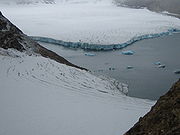
by glacial ice even in 2002, when the ice shelves began retreating rapidly in this area, so that by 2005 it was no longer attached to the mainland. Members of the scientific community believe this newly discovered island is a direct result of global warming
Global warming
Global warming refers to the rising average temperature of Earth's atmosphere and oceans and its projected continuation. In the last 100 years, Earth's average surface temperature increased by about with about two thirds of the increase occurring over just the last three decades...
. The island has three large peninsulas, and thus resembles the letter W.
Controversy

Patrick Michaels
Patrick J. Michaels is an American climatologist. Michaels is a senior research fellow for Research and Economic Development at George Mason University, and a senior fellow in environmental studies at the Cato Institute...
, a climatologist and prominent climate change skeptic, created a controversy over the history of Warming Island in a post on his website, World Climate Report
World Climate Report
World Climate Report, a newsletter edited by Patrick Michaels, was produced by the Greening Earth Society, a non-profit organization created by the Western Fuels Association....
, in which he argued that the island had been previously uncovered in the 1950s toward the end of a brief warm period in Greenland.
Despite a general lack of suitably detailed maps, Michaels found a map published by Ernst Hofer, a photographer who did aerial surveys of the area in the early 1950s, which showed the Warming Island landmass unconnected to Greenland. Michaels concluded, therefore that Warming Island was also a separate island when observed by Hofer in the 1950s, and more broadly that Warming Island is an example of unjustified concern about the future outcomes of global warming.
Dennis Schmitt countered Michaels' theory in an article by New York Times reporter Andy Revkin, contending that Hofer's map is inaccurate. Citing discrepancies such as the absence on Hofer's map of nearby Reynolds Island, he suggested that the discrepant features are consistent with an aerial view of the area when covered with fog, which has often obscured low-lying areas like Reynold's Island and the ice-bridge connecting Warming Island to the Greenlandic mainland. He further observed, "I see by the markings of the 1957 document that it is to be construed as indeed only schematic, that it is explicitly incomplete."
Michaels explained that Hofer included the map in his book "so as to place his pictures and stories in context."
No photographic evidence is available that would resolve the issue.
The island was also part of a 2011 controversy when it was included in the Times Atlas of the World
Times Atlas of the World
The Times Atlas of the World, rebranded The Times Atlas of the World: Comprehensive Edition in its 11th edition and The Times Comprehensive Atlas of the World from its 12th edition, is a world atlas currently published by HarperCollins...
, along with a revised depiction of the Greenland ice sheet
Greenland ice sheet
The Greenland ice sheet is a vast body of ice covering , roughly 80% of the surface of Greenland. It is the second largest ice body in the world, after the Antarctic Ice Sheet. The ice sheet is almost long in a north-south direction, and its greatest width is at a latitude of 77°N, near its...
that showed a 15% reduction. After being alerted through the media, the U.S. National Snow and Ice Data Center
National Snow and Ice Data Center
The National Snow and Ice Data Center, or NSIDC, is a United States information and referral center in support of polar and cryospheric research...
reported that the atlas editors must have used a 2001 map showing only the thickest segment of the ice sheet.
External links
- The Independent: An island made by global warming, 24 April 2007
- USGS Landsat Project: Warming Island, comparison of satellite pictures between 1985 and 2005