
Uppingham Rural District
Encyclopedia
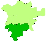
Uppingham was a rural district
in Rutland
, England
from 1894 to 1974, covering the south-west of the county.
The rural district was formed by the Local Government Act 1894
from the part of the Uppingham rural sanitary district
in Rutland. At the same time, the remainder of Uppingham RSD, which lay in Leicestershire
and Northamptonshire
became Hallaton Rural District
and Gretton Rural District
respectively.
The only town in the district was Uppingham
.
The rural district was abolished in 1974 by the Local Government Act 1972
. Oakham RD was merged with three other authorities to become the non-metropolitan district
of Rutland.
es:
Rural district
Rural districts were a type of local government area – now superseded – established at the end of the 19th century in England, Wales, and Ireland for the administration of predominantly rural areas at a level lower than that of the administrative counties.-England and Wales:In England...
in Rutland
Rutland
Rutland is a landlocked county in central England, bounded on the west and north by Leicestershire, northeast by Lincolnshire and southeast by Peterborough and Northamptonshire....
, England
England
England is a country that is part of the United Kingdom. It shares land borders with Scotland to the north and Wales to the west; the Irish Sea is to the north west, the Celtic Sea to the south west, with the North Sea to the east and the English Channel to the south separating it from continental...
from 1894 to 1974, covering the south-west of the county.
The rural district was formed by the Local Government Act 1894
Local Government Act 1894
The Local Government Act 1894 was an Act of the Parliament of the United Kingdom that reformed local government in England and Wales outside the County of London. The Act followed the reforms carried out at county level under the Local Government Act 1888...
from the part of the Uppingham rural sanitary district
Sanitary district
Sanitary districts were established in England and Wales in 1875 and in Ireland in 1878. The districts were of two types, based on existing structures:*Urban sanitary districts in towns with existing local government bodies...
in Rutland. At the same time, the remainder of Uppingham RSD, which lay in Leicestershire
Leicestershire
Leicestershire is a landlocked county in the English Midlands. It takes its name from the heavily populated City of Leicester, traditionally its administrative centre, although the City of Leicester unitary authority is today administered separately from the rest of Leicestershire...
and Northamptonshire
Northamptonshire
Northamptonshire is a landlocked county in the English East Midlands, with a population of 629,676 as at the 2001 census. It has boundaries with the ceremonial counties of Warwickshire to the west, Leicestershire and Rutland to the north, Cambridgeshire to the east, Bedfordshire to the south-east,...
became Hallaton Rural District
Hallaton Rural District
The rural district of Hallaton existed in Leicestershire, England from 1894 to 1935. It included the following civil parishes, which were the parts of the Uppingham Rural Sanitary District in Leicestershire.*Blaston*Bringhurst*Drayton*Great Easton...
and Gretton Rural District
Gretton Rural District
Gretton was a rural district in Northamptonshire, England from 1894 to 1935. It was formed from the Northamptonshire part of the Uppingham rural sanitary district .It consisted of the following...
respectively.
The only town in the district was Uppingham
Uppingham
Disambiguation: "Uppingham" is the colloquial name for Uppingham SchoolUppingham is a market town in the county of Rutland in the East Midlands of England, located on the A47 between Leicester and Peterborough, about 6 miles south of the county town, Oakham.- History :A little over a mile to the...
.
The rural district was abolished in 1974 by the Local Government Act 1972
Local Government Act 1972
The Local Government Act 1972 is an Act of Parliament in the United Kingdom that reformed local government in England and Wales on 1 April 1974....
. Oakham RD was merged with three other authorities to become the non-metropolitan district
Non-metropolitan district
Non-metropolitan districts, or colloquially shire districts, are a type of local government district in England. As created, they are sub-divisions of non-metropolitan counties in a so-called "two-tier" arrangement...
of Rutland.
Parishes
The rural district consisted of twenty civil parishCivil parish
In England, a civil parish is a territorial designation and, where they are found, the lowest tier of local government below districts and counties...
es:
- AystonAystonAyston is a village and civil parish in the county of Rutland in the East Midlands of England. It is located about one mile north-west of Uppingham close to the junction of the A47 and A6003....
- BarrowdenBarrowdenBarrowden is a village and civil parish in the county of Rutland in the East Midlands of England. It is often considered to be one of the more picturesque villages in Rutland due to its beautiful setting amongst hills and rivers, and also because of the open village greens and the village...
- Beaumont ChaseBeaumont ChaseBeaumont Chase is a civil parish in the county of Rutland in the East Midlands of England. It is situated to the west of Uppingham and north of Stoke Dry on a steep hillside overlooking Leicestershire. Formerly an extra-parochial area, it was created a separate parish in 1858.There is one...
- Belton
- BisbrookeBisbrookeBisbrooke is a village and civil parish in the county of Rutland in the East Midlands of England. It is located about two miles east of Uppingham close to the A47. In 2001, it had a population of 219....
- CaldecottCaldecott, RutlandCaldecott is a village in the county of Rutland in the East Midlands of England. It is located about four miles south of Uppingham and is the most southerly village in Rutland....
- GlastonGlastonGlaston is a village in the county of Rutland in the East Midlands of England.Glaston is about four miles south of Rutland Water and is on the A47 two miles east of Uppingham. There are approximately 80 houses in total with one public house 'The Old Pheasant' on Main Road , and a flooring...
- Liddington
- North LuffenhamNorth LuffenhamNorth Luffenham is a village in Rutland, in the East Midlands of England. It lies to the north of the River Chater, east of Uppingham and west of Stamford.Located to the north of the village is St George's Barracks, formerly RAF North Luffenham....
- MorcottMorcottMorcott is a village in the county of Rutland in the East Midlands of England. It is located about seven miles south-east of Oakham on the A47 and A6121 roads.The village railway station on the branch line between Seaton and Luffenham closed in 1966...
- PiltonPilton, RutlandPilton is a small village and civil parish in the county of Rutland in the East Midlands of England.It is a mile or two south of Rutland Water, and near North Luffenham, Wing and Lyndon...
- PrestonPreston, RutlandPreston is a village and civil parish in the county of Rutland in the East Midlands of England. It lies north of Uppingham on the A6003 to Oakham....
- RidlingtonRidlingtonRidlington is a village and civil parish in Rutland in the East Midlands of England.The Church of England parish church is Saint Mary Magdalene and Saint Andrew.-External links:*...
- SeatonSeaton, RutlandSeaton is a village and civil parish in the county of Rutland in the East Midlands of England.Nearby is the large Seaton Viaduct, on the Oakham to Kettering railway line. It is three quarters of a mile long and took four years to build. It has 82 arches which are up to high. The railway is now...
- South LuffenhamSouth LuffenhamSouth Luffenham is a village in the county of Rutland in the East Midlands of England.The village lies largely on the north side of the A6121 road from Uppingham to Stamford. It is divided into two by a small stream, the Foss, which is a tributary of the River Chater...
- Stoke DryStoke DryStoke Dry is a village in the county of Rutland in the East Midlands of England, about three miles southwest of Uppingham.In 2007 it had a population of 39. With only 14 homes this is a quiet village with its mediaeval church dedicated to Saint Andrew...
- Thorpe by WaterThorpe by WaterThorpe by Water is a village and civil parish in the county of Rutland in the East Midlands of England....
- UppinghamUppinghamDisambiguation: "Uppingham" is the colloquial name for Uppingham SchoolUppingham is a market town in the county of Rutland in the East Midlands of England, located on the A47 between Leicester and Peterborough, about 6 miles south of the county town, Oakham.- History :A little over a mile to the...
- WardleyWardley, RutlandWardley is a village and civil parish in the county of Rutland in the East Midlands of England. It is located about two miles west of Uppingham, close to the A47. The two-mile £1.9 million Wardley Hill Improvement opened in October 1987 when the road through the village became a dead end...
- WingWing, RutlandWing is a small village and civil parish in the county of Rutland in the East Midlands of England.-Architecture:The 17th-century houses in Wing were built from stone quarried at nearby Barnack and Clipsham. Many are roofed with Collyweston stone slate....