

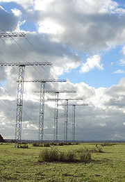
Unwin Radar
Encyclopedia
Awarua Plain
thumb|Awarua Plain , [[Tiwai Point]] and [[Bluff, New Zealand|Bluff]] viewed from the [[International Space Station]] in 2008....
, near Invercargill
Invercargill
Invercargill is the southernmost and westernmost city in New Zealand, and one of the southernmost cities in the world. It is the commercial centre of the Southland region. It lies in the heart of the wide expanse of the Southland Plains on the Oreti or New River some 18 km north of Bluff,...
, New Zealand
New Zealand
New Zealand is an island country in the south-western Pacific Ocean comprising two main landmasses and numerous smaller islands. The country is situated some east of Australia across the Tasman Sea, and roughly south of the Pacific island nations of New Caledonia, Fiji, and Tonga...
46.51°S 168.38°E. It is part of the Super Dual Auroral Radar Network
Super Dual Auroral Radar Network
The Super Dual Auroral Radar Network is an international radar network for studying the upper atmosphere and ionosphere, comprising eleven radars in the northern hemisphere and seven in the southern hemisphere that operate in the High Frequency bands between 8 and 22 MHz...
(SuperDARN), an international radar network for studying the upper atmosphere and ionosphere that operates in the High Frequency
High frequency
High frequency radio frequencies are between 3 and 30 MHz. Also known as the decameter band or decameter wave as the wavelengths range from one to ten decameters . Frequencies immediately below HF are denoted Medium-frequency , and the next higher frequencies are known as Very high frequency...
(HF) bands between 8 and 22 MHz. The radar and associated research provides greater understanding of atmospheric weather, to assist with weather prediction, prediction of telecommunication interference and provide a better understanding of the effects of atmospheric magnetic fields on power grid management.
The facility is operated by La Trobe University
La Trobe University
La Trobe University is a multi-campus university in Victoria, Australia. It was established in 1964 by an Act of Parliament to become the third oldest university in the state of Victoria. The main campus of La Trobe is located in the Melbourne suburb of Bundoora; two other major campuses are...
and was named after Bob Unwin, a pioneer in auroral radar research, who first proposed the concept behind the project in the 1960's
Operation
Bursts of short-wave radio pulses are transmitted from the radar in a southern arc that includes the South Magnetic PoleSouth Magnetic Pole
The Earth's South Magnetic Pole is the wandering point on the Earth's surface where the geomagnetic field lines are directed vertically upwards...
. The ensuing reflections from micro-meteorites, the ionosphere
Ionosphere
The ionosphere is a part of the upper atmosphere, comprising portions of the mesosphere, thermosphere and exosphere, distinguished because it is ionized by solar radiation. It plays an important part in atmospheric electricity and forms the inner edge of the magnetosphere...
, ocean
Ocean
An ocean is a major body of saline water, and a principal component of the hydrosphere. Approximately 71% of the Earth's surface is covered by ocean, a continuous body of water that is customarily divided into several principal oceans and smaller seas.More than half of this area is over 3,000...
and aurora
Aurora (astronomy)
An aurora is a natural light display in the sky particularly in the high latitude regions, caused by the collision of energetic charged particles with atoms in the high altitude atmosphere...
are detected at the station and resolved there. The data from Unwin is transmitted back to La Trobe University
La Trobe University
La Trobe University is a multi-campus university in Victoria, Australia. It was established in 1964 by an Act of Parliament to become the third oldest university in the state of Victoria. The main campus of La Trobe is located in the Melbourne suburb of Bundoora; two other major campuses are...
where it is made available over the Internet to users. The Unwin Radar and its counterpart at Bruny Island in Tasmania
Tasmania
Tasmania is an Australian island and state. It is south of the continent, separated by Bass Strait. The state includes the island of Tasmania—the 26th largest island in the world—and the surrounding islands. The state has a population of 507,626 , of whom almost half reside in the greater Hobart...
form the Tasman International Geospace Environment Radar (TIGER).
Southland is regarded as an ideal location for such a facility because of the southerly aspect, low radio noise and unobstructed horizon.