
University Metro station
Encyclopedia
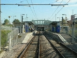
University Metro Station on the Tyne and Wear Metro
is located on the western fringe of Sunderland City Centre, and is the nearest station to the University of Sunderland
's City Campus.
It opened as part of the Sunderland extension in 2002 and is one of the three stations serving the city centre of Sunderland, the others being Park Lane and Sunderland (Central).
The station can be accessed by footpaths from the A183
Chester Road and the A690
New Durham Road.
Tyne and Wear Metro
The Tyne and Wear Metro, also known as the Metro, is a light rail system in North East England, serving Newcastle upon Tyne, Gateshead, South Tyneside, North Tyneside and Sunderland. It opened in 1980 and in 2007–2008 provided 40 million public journeys on its network of nearly...
is located on the western fringe of Sunderland City Centre, and is the nearest station to the University of Sunderland
University of Sunderland
The University of Sunderland is located in Sunderland, north east England. The university has more than 17,500 students, including 7,000-plus international students from some 70 countries....
's City Campus.
It opened as part of the Sunderland extension in 2002 and is one of the three stations serving the city centre of Sunderland, the others being Park Lane and Sunderland (Central).
The station can be accessed by footpaths from the A183
A183 road
The A183 road runs from South Shields in Tyne and Wear, through Sunderland and ends at Chester-le-Street in County Durham. It is a major route in South Tyneside, Sunderland and Chester-le-Street serving many areas and landmarks along its route....
Chester Road and the A690
A690 road
The A690 is a road in County Durham running from Sunderland in the east through Durham to Crook.-Sunderland section:Throughout the Sunderland section it is known as either Durham Road or New Durham Road, and is one of the major routes in and out of the city. A single carriageway section runs from...
New Durham Road.
External links
- Train times and station information for University Metro station from NexusTyne and Wear Passenger Transport ExecutiveThe Tyne and Wear Passenger Transport Executive using the brandname of Nexus, is the Passenger Transport Executive for the Tyne and Wear region of North East England....