

Udumalaipettai
Encyclopedia
Udumalai also known as Udumalpet is a town and a municipality
in Tirupur district
, India
n state
of Tamil Nadu
.
Poor Man's Ooty, as it is called, the Udumalpet town is one of the famous summer resorts of Tamil Nadu, surrounded by Mountains on three sides.
Its name in the ancient days was "UDUMALAI" and due to its rural atmosphere, it was also named as Pettai. In latter period it was changed as "UDUMALAIPETTAI" in Tamil.
The city was previously under Coimbatore district but was moved under the newly formed Tirupur district in October 2008. The change was opposed by many of the residents but it was not reverted back. In short known as Udumalai, the city is surrounded by the high mountains of Western Ghats on three sides. This Municipal town has a population of about 60,000. Udumalpet is an industrial town with number of textile, paper and farming related industries established here. Famous landmarks and monuments in and around the town includes Thirumoorthy Hills
,which has the Thirumurthi water reservoir that provides water supply to the town, Mariamman Temple, an old worshiping place in the town center and Amaravathi Reservoir
, across Amaravathi River which provides irrigation to the agricultural lands around the town. Both Thirumoorthy Hills
and Amaravathi Reservoir provide recreational activities such as boating, fishing and hiking and attract tourists from other parts of the state. Udumalpet lies between the famous temple town of Palani (35 km)and Pollachi (28 km)on the National Highway No.209. Udumalpet is also connected by a metre gauge railway line.
Udumalpet assembly constituency is part of Pollachi (Lok Sabha constituency)
.
, in Udumalaipettai, there are 14,889 households. The total population is 59,668 with 29,330 males and 30,338 females. Males constitute 49% of the population and females 51%. Udumalaipettai has an average literacy rate of 81%, higher than the national average of 59.5%: male literacy is 85%, and female literacy is 77%. Interestingly, 8% of the population is under 6 years of age. The town is known for its moderate climate ( Max 36 degree - Min 15 Degree), cultured people, good food and good water from Thirumoorthy Hills.
of Tamil Nadu is located at Amaravathinagar
which is 21 km from Udumalpet. Other schools in the town are Sri Kanniga Parameswari higher secondary school, Srinivasa Vidhyalaya, RGMHSS, Stella Maris and a few others. Over the years, schools in Udumalpet have consistently produced students who have scored top ranks in State examinations.
The colleges in the town include Government Arts College, which is a state funded college, Sri GVG Visalakhi College founded by late Sri G.V.Govindasamy Naidu is one of the renowned women's college in the area and the privately owned Vidhysagar College of Arts and Science located on the National Highway 209. Rudhraveni Muthusamy Polytechnic is one of the famous polytechnics in the area which provides technical education. Its located between palani and udumalpet NH 209.
The town, in the 1980s and 1990s, had a well-developed spinning industry but it has since declined due to labor shortages and other labor related issues. One of the biggest poultry companies in India, Suguna Poultry Ltd, was founded in this town. There are many paper manufacturing plants located alongside the Amaravathi River. Recently, surrounding areas of the town has seen a huge rise in windmill installations. The location of the town across the Palghat Gap, aids tunneling of the wind flow through the region and aids in wind power generation..
 The town is surrounded by hills and has a good weather throughout the year. Waterfalls in Thirumoorthy hills draw quite a few tourists. It takes half an hour to reach the falls by trekking from the Thirumoorthy temple. The Thirumoorthy temple is a scenic place with Amanalingeshwarar Thirukkoil at the foot hills. The way atop the hill is pretty exciting up to some 1 km and extremely challenging to go beyond that. It is said if you bend and crawl for about 40 meters beneath a rock behind Panchalingam, you could reach the next layer of Western Ghats
, i.e., the plain between two adjacent hills and it is said that even tigers exist there.
A drive from Udumalpet to Munnar gives one unforgettable views of the Western Ghats. Chinnar is 25 km from Udumalpet and is home to the Indra Gandhi wildlife sanctuary which is famous for known for the elephants that inhabit the area. Chinnar is also the border between Tamil Nadu and Kerala. As you cross the Tamil Nadu border and enter Kerala, you can see a distinct change in the vegetation. While the Tamil Nadu areas have vegetation dominated by shrubs and thorny trees, the vegetation in Kerala is lush green with tall trees. Marayur is 20 km from Chinnar, famous for its sandalwood forests which often fall prey to poachers.
As you drive past Marayur towards Munnar
, you can see Anamudi
, the highest mountain peak in south part of India to your right. This area also houses the Eravikulam National Park famous for its population of the Nilgiri Tahr, a mountain goat. This area offers abundant scope for mountain trekking. On the trekking route to the Anamudi peak, you can see a Trout farm. The rest of the drive towards Munnar
is through neatly manicured tea estates owned by Tata Tea Limited and Waterfall Estate. The landscape is also dotted by tea factories and labour lines.
There is also a trekking route from Amaravathi Dam
to Kodaikanal
which is frequented by the students of the Amaravathi Sainik School(only one sainik school in Tamil nadu). The villages surrounding Udumalpet are well known for their beauty. Villages are criss-crossed by Amaravathi River and various irrigation canals. Coconut tree farms are common sight and this area is one of the leading producer of coconuts in the region. The countryside is a popular film shooting spot, providing scenic backgrounds and greenery. Thirumoorthy hills houses a beautiful dam which is a very famous shooting spot for Tamil movies and Malayalam movies.
famous temples:
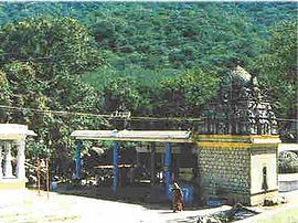
1.Prasanna Vinaayagar Temple,Udumalpet town
2.Maariyamman temple,Udumalpet town
3.kottai mariyamman temple ,sangrama nalloor
4.Ezhumalayaan temple,sevenhills
5.Ujjaini Mahakaalitemple,Chinnaveerampatti
Dams
1.Tirumoorthidam (Thoniyaaru or thirumoorthi falls)
(this dam supplies water to Udumalai for drinking purpose,this water is famouse for its
sweetness)
2.Amaravathi dam (Amaravathi river & paambaaru)
3.Kaadambaarai dam
main source of income:
Agriculture is prominent here .coconut is cultivating in more than 22000 hectres.
nearest towns
1.Pollachi 27 km
2.Palani 38 km
3.Coimbatore 65 km
4.Tiruppur 70 km
5.munnar 90 km
6.Trissur 135 km
Transport :
bus service:
frequent buses to
1.pollachi
2.Coimbatore (through Pollachi and also Palladam )
3.Palani
4.Palladam
5.Tiruppur (through Palladam )
6.Munnar ( Jeep service also available from here)
Train route:
in Dindugal to Palakkad route
, the most famous Kollywood comedian (Comedy Kadavul)
Udumalai Narayana Kavi
, a renowned poet was from this town,actor vaiyaapuri
Mr.B.Sabarirajan, a growing tamil poet writer in Pallapalayam,Udumalpet.
Mr.Kavignar Kaarko allias Ananth ,a growing tamil poet,cinema song writer,assistant director from Udumalpet town
*Assembly constituency:
2.Madathukkulam
*Revenue divisions
i)Udumalpet Taluk
ii)Madathukulam Taluk
*Municipalities
*Village Panchayats
Municipality
A municipality is essentially an urban administrative division having corporate status and usually powers of self-government. It can also be used to mean the governing body of a municipality. A municipality is a general-purpose administrative subdivision, as opposed to a special-purpose district...
in Tirupur district
Tirupur district
Tiruppur District is a district of the Indian state Tamil Nadu, formed in October 2008. This district is formed with these taluks from Coimbatore district and Erode district: Tirupur, Avinashi, Palladam, Dharapuram, Kangeyam, Madathukulam and Udumalpet. Tirupur district is a well-developed and...
, India
India
India , officially the Republic of India , is a country in South Asia. It is the seventh-largest country by geographical area, the second-most populous country with over 1.2 billion people, and the most populous democracy in the world...
n state
States and territories of India
India is a federal union of states comprising twenty-eight states and seven union territories. The states and territories are further subdivided into districts and so on.-List of states and territories:...
of Tamil Nadu
Tamil Nadu
Tamil Nadu is one of the 28 states of India. Its capital and largest city is Chennai. Tamil Nadu lies in the southernmost part of the Indian Peninsula and is bordered by the union territory of Pondicherry, and the states of Kerala, Karnataka, and Andhra Pradesh...
.
Poor Man's Ooty, as it is called, the Udumalpet town is one of the famous summer resorts of Tamil Nadu, surrounded by Mountains on three sides.
Its name in the ancient days was "UDUMALAI" and due to its rural atmosphere, it was also named as Pettai. In latter period it was changed as "UDUMALAIPETTAI" in Tamil.
The city was previously under Coimbatore district but was moved under the newly formed Tirupur district in October 2008. The change was opposed by many of the residents but it was not reverted back. In short known as Udumalai, the city is surrounded by the high mountains of Western Ghats on three sides. This Municipal town has a population of about 60,000. Udumalpet is an industrial town with number of textile, paper and farming related industries established here. Famous landmarks and monuments in and around the town includes Thirumoorthy Hills
Thirumoorthy Hills
Thirumoorthy Temple is situated at the foot of the Thirumoorthy hills or Thirumoorthi hills adjoining the Thirumoorthy dam. The scenic beauty of the Anamalai hill range of Western Ghats, includes the cascading water to the Thirumoorthy reservoir from the Panchalingam Falls. A perennial stream flows...
,which has the Thirumurthi water reservoir that provides water supply to the town, Mariamman Temple, an old worshiping place in the town center and Amaravathi Reservoir
Amaravathi Reservoir
Amaravathi Reservoir at Amaravathinagar, south on SH 17 from Udumalpet, is located in Indira Gandhi Wildlife Sanctuary and National Park in Tirupur district, Tamil Nadu, India. The reservoir was created by the steep Amaravathi Dam built across the Amaravathi River. Amaravathi river is tributary...
, across Amaravathi River which provides irrigation to the agricultural lands around the town. Both Thirumoorthy Hills
Thirumoorthy Hills
Thirumoorthy Temple is situated at the foot of the Thirumoorthy hills or Thirumoorthi hills adjoining the Thirumoorthy dam. The scenic beauty of the Anamalai hill range of Western Ghats, includes the cascading water to the Thirumoorthy reservoir from the Panchalingam Falls. A perennial stream flows...
and Amaravathi Reservoir provide recreational activities such as boating, fishing and hiking and attract tourists from other parts of the state. Udumalpet lies between the famous temple town of Palani (35 km)and Pollachi (28 km)on the National Highway No.209. Udumalpet is also connected by a metre gauge railway line.
Udumalpet assembly constituency is part of Pollachi (Lok Sabha constituency)
Pollachi (Lok Sabha constituency)
-Before 2009:#Kinathukkadavu#Pollachi#Valparai #Udumalpet#Pongalur#Dharapuram -2009-present:#Thondamuthur#Kinathukadavu#Pollachi#Valparai #Udumalpet#Madathukulam-Members of Parliament:...
.
Demographics
India censusCensus
A census is the procedure of systematically acquiring and recording information about the members of a given population. It is a regularly occurring and official count of a particular population. The term is used mostly in connection with national population and housing censuses; other common...
, in Udumalaipettai, there are 14,889 households. The total population is 59,668 with 29,330 males and 30,338 females. Males constitute 49% of the population and females 51%. Udumalaipettai has an average literacy rate of 81%, higher than the national average of 59.5%: male literacy is 85%, and female literacy is 77%. Interestingly, 8% of the population is under 6 years of age. The town is known for its moderate climate ( Max 36 degree - Min 15 Degree), cultured people, good food and good water from Thirumoorthy Hills.
Education
Udumalpet is well known for its schools and educational institutes. There are about eleven higher secondary schools and three colleges. The Government Higher Secondary School was established during British rule and is a model for best performing schools in the government sector. The only Sainik SchoolSainik School
The Sainik Schools are a system of schools in India established and managed by the Sainik Schools Society. They were conceived in 1961 by V. K. Krishna Menon, the then Defence Minister of India, to rectify the regional and class imbalance amongst the Officer cadre of the Indian Military, and to...
of Tamil Nadu is located at Amaravathinagar
Amaravathinagar
Amaravathinagar is a village in the foothills of Annamalai Hills in Coimbatore district, Tamil Nadu, India; 17.6 km south on SH 17 from Udumalpet and around 90 km from Coimbatore city...
which is 21 km from Udumalpet. Other schools in the town are Sri Kanniga Parameswari higher secondary school, Srinivasa Vidhyalaya, RGMHSS, Stella Maris and a few others. Over the years, schools in Udumalpet have consistently produced students who have scored top ranks in State examinations.
The colleges in the town include Government Arts College, which is a state funded college, Sri GVG Visalakhi College founded by late Sri G.V.Govindasamy Naidu is one of the renowned women's college in the area and the privately owned Vidhysagar College of Arts and Science located on the National Highway 209. Rudhraveni Muthusamy Polytechnic is one of the famous polytechnics in the area which provides technical education. Its located between palani and udumalpet NH 209.
Economy
Up until 1980s, the town was blessed with good rains from both the South West and North East monsoons and formed a rich agricultural belt cultivating seasonal/annual crops such as groundnut, cotton, maize, sugarcane etc. However, since then, the area has become part of the tail end of both the monsoons. Shortage of farm labor led to conversion of seasonal cropping areas into coconut groves which require heavy irrigation round the year. Both this and the scarcity of the monsoon rains rapidly led to depletion of ground water resources and to a lower water table. The scarcity of ground water resulted in several non-agricultural activities springing up in the town like poultry farms etc.The town, in the 1980s and 1990s, had a well-developed spinning industry but it has since declined due to labor shortages and other labor related issues. One of the biggest poultry companies in India, Suguna Poultry Ltd, was founded in this town. There are many paper manufacturing plants located alongside the Amaravathi River. Recently, surrounding areas of the town has seen a huge rise in windmill installations. The location of the town across the Palghat Gap, aids tunneling of the wind flow through the region and aids in wind power generation..
Tourism and natural beauty
Western Ghats
The Western Ghats, Western Ghauts or the Sahyādri is a mountain range along the western side of India. It runs north to south along the western edge of the Deccan Plateau, and separates the plateau from a narrow coastal plain along the Arabian Sea. The Western Ghats block rainfall to the Deccan...
, i.e., the plain between two adjacent hills and it is said that even tigers exist there.
A drive from Udumalpet to Munnar gives one unforgettable views of the Western Ghats. Chinnar is 25 km from Udumalpet and is home to the Indra Gandhi wildlife sanctuary which is famous for known for the elephants that inhabit the area. Chinnar is also the border between Tamil Nadu and Kerala. As you cross the Tamil Nadu border and enter Kerala, you can see a distinct change in the vegetation. While the Tamil Nadu areas have vegetation dominated by shrubs and thorny trees, the vegetation in Kerala is lush green with tall trees. Marayur is 20 km from Chinnar, famous for its sandalwood forests which often fall prey to poachers.
As you drive past Marayur towards Munnar
Munnar
Munnar is one of the most popular hill station in Kerala and in southern India. Munnar is located on the Western Ghats, situated in the Idukki district....
, you can see Anamudi
Anamudi
Anamudi is located in the Indian state Kerala. It is the highest peak in the Western Ghats and South India, at an elevation of , and a topographic prominence of...
, the highest mountain peak in south part of India to your right. This area also houses the Eravikulam National Park famous for its population of the Nilgiri Tahr, a mountain goat. This area offers abundant scope for mountain trekking. On the trekking route to the Anamudi peak, you can see a Trout farm. The rest of the drive towards Munnar
Munnar
Munnar is one of the most popular hill station in Kerala and in southern India. Munnar is located on the Western Ghats, situated in the Idukki district....
is through neatly manicured tea estates owned by Tata Tea Limited and Waterfall Estate. The landscape is also dotted by tea factories and labour lines.
There is also a trekking route from Amaravathi Dam
Amaravathi Dam
Amaravathi Dam at Amaravathinagar, 25 km south on NH 17 from Udumalpet, is located in Indira Gandhi Wildlife Sanctuary in Coimbatore district, Tamil Nadu, India. The 9.31 km², 33.53 m deep Amaravathi Reservoir was created by this steep dam. It was built primarily for irrigation and flood...
to Kodaikanal
Kodaikanal
-Climate:Kodaikanal has a monsoon-influenced subtropical highland climate . The temperatures are cool throughout the year due to the high elevation of the city.-Economy:...
which is frequented by the students of the Amaravathi Sainik School(only one sainik school in Tamil nadu). The villages surrounding Udumalpet are well known for their beauty. Villages are criss-crossed by Amaravathi River and various irrigation canals. Coconut tree farms are common sight and this area is one of the leading producer of coconuts in the region. The countryside is a popular film shooting spot, providing scenic backgrounds and greenery. Thirumoorthy hills houses a beautiful dam which is a very famous shooting spot for Tamil movies and Malayalam movies.
famous temples:
1.Prasanna Vinaayagar Temple,Udumalpet town
2.Maariyamman temple,Udumalpet town
3.kottai mariyamman temple ,sangrama nalloor
4.Ezhumalayaan temple,sevenhills
5.Ujjaini Mahakaalitemple,Chinnaveerampatti
Dams
1.Tirumoorthidam (Thoniyaaru or thirumoorthi falls)
(this dam supplies water to Udumalai for drinking purpose,this water is famouse for its
sweetness)
2.Amaravathi dam (Amaravathi river & paambaaru)
3.Kaadambaarai dam
main source of income:
Agriculture is prominent here .coconut is cultivating in more than 22000 hectres.
nearest towns
1.Pollachi 27 km
2.Palani 38 km
3.Coimbatore 65 km
4.Tiruppur 70 km
5.munnar 90 km
6.Trissur 135 km
Transport :
bus service:
frequent buses to
1.pollachi
2.Coimbatore (through Pollachi and also Palladam )
3.Palani
4.Palladam
5.Tiruppur (through Palladam )
6.Munnar ( Jeep service also available from here)
Train route:
in Dindugal to Palakkad route
Notable people
GoundamaniGoundamani
Goundamani is a Tamil film actor, comedian and screen icon. He is considered as the greatest comic actor in Kollywood and is renowned for his alliance with fellow actor Senthil.-Early Life:...
, the most famous Kollywood comedian (Comedy Kadavul)
Udumalai Narayana Kavi
Udumalai Narayana Kavi
Udumalai Narayana Kavi was an Indian poet.He was born to a poor family in Poolavadi, a small village in Udumalpet taluk, Coimbatore district, Tamil Nadu, India...
, a renowned poet was from this town,actor vaiyaapuri
Mr.B.Sabarirajan, a growing tamil poet writer in Pallapalayam,Udumalpet.
Mr.Kavignar Kaarko allias Ananth ,a growing tamil poet,cinema song writer,assistant director from Udumalpet town
Administration and politics
*Parliamentary constituency:- 1.Pollachi
*Assembly constituency:
- 1.Udumalpet
2.Madathukkulam
*Revenue divisions
- 1.Dharapuram:
i)Udumalpet Taluk
ii)Madathukulam Taluk
*Municipalities
- 1.Udumalpet
*Village Panchayats
- 1. MoongiltholuvuMoongiltholuvuMoongiltholuv is a village and Village Panchayat in Madathukulam Taluk, Tirupur Distirict , Tamil Nadu, India.Moongiltholuvu gets its name from once abundant presence of bambooin this...
- 2. Kandiagoundanpudur
- 3. Periyakottai
- 4. AndiagoundanoorAndiagoundanoorAndiagoundanoor village panchayat is one of the largest geographical area panchayat in Udumalpet, Tamil Nadu, India. The village panchayat office is situated in Uralpatty. The panchayat comprises the following villages:1. Uralpatty2. Jakkampalayam...
- 5. Bodipatti
- 6. Kuralkuttai
- 7. Pulankinar
- 8. Kanakampalayam
- 9. chinna veeram patti
- 10.kurunjeri