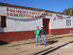
Tuxpan de Bolaños
Encyclopedia

Bolaños
The municipality of Bolaños is located in the north of the Mexican state of Jalisco.The municipality shares its border on the north with the municipalities of Mezquitic and Villa Guerrero and to the southeast with the municipality of Chimaltitán...
, Jalisco
Jalisco
Jalisco officially Estado Libre y Soberano de Jalisco is one of the 31 states which, with the Federal District, comprise the 32 Federal Entities of Mexico. It is located in Western Mexico and divided in 125 municipalities and its capital city is Guadalajara.It is one of the more important states...
, Mexico
Mexico
The United Mexican States , commonly known as Mexico , is a federal constitutional republic in North America. It is bordered on the north by the United States; on the south and west by the Pacific Ocean; on the southeast by Guatemala, Belize, and the Caribbean Sea; and on the east by the Gulf of...
. The village is called Tutsipa in the native Wixárika language
Huichol language
The Huichol language is an indigenous language of Mexico which belongs to the Uto-Aztecan language family. It is spoken by the ethnic group widely known as the Huichol , whose mountainous territory extends over portions of the Mexican states of Jalisco, Nayarit, and Durango, mostly in Jalisco...
. The village is located at 21.5229 degrees latitude North and 104.0047 degrees longitude West. It rests at an altitude of 1,120 meters (3,674 feet)above sea level.
According to the 2005 census, the village had a population of 944 inhabitants.

San Andrés Cohamiata
San Andrés Cohamiata is an autonomously governed Wixárika village located in Mezquitic, Jalisco, Mexico. The village is called Tatei Kié in the native Wixárika language....
(Tatei Kié) which are all in the state of Jalisco, and Guadalupe Ocotán (Xatsitsarie) in the state of Nayarit
Nayarit
Nayarit officially Estado Libre y Soberano de Nayarit is one of the 31 states which, with the Federal District, comprise the 32 Federal Entities of Mexico. It is divided in 20 municipalities and its capital city is Tepic.It is located in Western Mexico...
.

