

Tutong District
Encyclopedia
Districts of Brunei
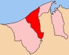
Brunei is divided into four districts :The districts are subdivided into thirty-eight mukim .-See also:*ISO 3166-2:BN*...
(daerah
Daerah
Daerah or Daïra |circle]]; plural dawaïr) is an Arabic language subdivision term.- Arab countries :* subdivisions of Algeria: below wilayah , see Daïra of Algeria...
) in Brunei
Brunei
Brunei , officially the State of Brunei Darussalam or the Nation of Brunei, the Abode of Peace , is a sovereign state located on the north coast of the island of Borneo, in Southeast Asia...
and its capital is Pekan Tutong
Pekan Tutong
This article refers to the town of Tutong. For the mukim of the same name, please refer to Pekan Tutong, Tutong. For other uses, please see Tutong....
or Tutong Town
Pekan Tutong
This article refers to the town of Tutong. For the mukim of the same name, please refer to Pekan Tutong, Tutong. For other uses, please see Tutong....
(in English). The district borders the South China Sea
South China Sea
The South China Sea is a marginal sea that is part of the Pacific Ocean, encompassing an area from the Singapore and Malacca Straits to the Strait of Taiwan of around...
to the north, the Bruneian district of Brunei and Muara and the Malaysian state of Sarawak
Sarawak
Sarawak is one of two Malaysian states on the island of Borneo. Known as Bumi Kenyalang , Sarawak is situated on the north-west of the island. It is the largest state in Malaysia followed by Sabah, the second largest state located to the North- East.The administrative capital is Kuching, which...
to the east and the Bruneian district of Belait
Belait District
Belait is the largest district in Brunei, as well as the western-most. The word 'Belait' is taken from the name of the native inhabitants of Belait, the Belait People. The district is administered from the town of Kuala Belait, its capital. Belait is governed by an appointed District Officer. The...
to the west. It has a population of 35,200, and covers 1,303 km² (503 mi²). The Sungai Tutong river flows through Tutong. A half-hour drive southwest from Bandar along Brunei's coastal highway will propel you from the Brunei-Muara District into the gradually more rural landscapes of Tutong District, and towards its namesake town of Tutong. Although bigger size than Brunei-Muara District with 1,166 km2 of territory, Tutong has a population of only around 34,100 including members of Borneo's ethnic tribes such as Tutong, Kedayan, Murut, Malay, Chinese and Dusun.
Mukim
In Brunei, a mukim is a subdivision of a daerah . The equivalent of the word 'mukim' in English would be 'sub-district'.In Malaysia, a mukim can either be a subdivision of a daerah or a subdivision of sub-district, In Singapore, a mukim is one of two varieties of survey...
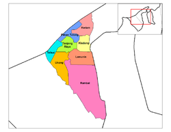
), namely:
- KeriamKeriamKeriam is a mukim in the Tutong District of Brunei. It is located in the north-east of the Tutong District facing the South China Sea, bordering Mukim Sengkurong to the south-east, Mukim Pengkalan Batu to the south-west, Mukim Kiudang to the south and Mukim Pekan Tutong to the west.-Areas and...
- KiudangKiudangKiudang is a mukim in the Tutong District of Brunei. It is located in the east of the Tutong District, bordering Mukim Keriam in the north, Mukim Pengkalan Batu to the north-east, Limbang, Sarawak to the south-east, Mukim Lamunin to the south and Mukim Tanjong Maya to the west and Mukim Pekan...
- LamuninLamuninLamunin is a mukim in the Tutong District of Brunei. It is located in the east, centre of the Tutong District, bordering Mukim Kiudang to the north, Limbang, Sarawak to the east, Mukim Rambai to the south and south-west, Mukim Ukong to the west and Mukim Tanjong Maya to north-west.-Areas and...
- Pekan TutongPekan Tutong, MukimPekan Tutong is a mukim in the Tutong District of Brunei. It is located in the north-west of the Tutong District facing the South China Sea, bordering Mukim Keriam to the north-east, Mukim Kiudang to the south-east, Mukim Tanjong Maya to the south and Mukim Telisai to the south-west...
- RambaiRambaiRambai is a mukim in the Tutong District of Brunei. It is located in the south bordering Mukim Lamunin to the north, Limbang, Sarawak to the east and south, Mukim Sukang to the south-west, Mukim Bukit Sawat to the west and Mukim Ukong to the north-west...
- Tanjong MayaTanjong MayaTanjang Maya is a mukim in the Tutong District of Brunei. It is located in the central north of the Tutong District bordering Mukim Pekan Tutong to the north, Mukim Kiudang to the east, Mukim Lamunin to the south-east, Mukim Ukong to the south-west and Mukim Telisai to the west.-Areas and...
- TelisaiTelisaiTelisai is a mukim in the Tutong District of Brunei. It is located in the west facing the South China Sea to the north, Mukim Pekan Tutong to the north-east, Mukim Tanjong Maya to the east, Mukim Ukong to the south-east, Mukim Bukit Sawat to the south and Mukim Liang to the south-west...
- UkongUkongUkong is a mukim in the Tutong District of Brunei. It is located in the south-west bordering Mukim Tanjong Maya to the north-east, Mukim Lamunin to the east, Mukim Rambai to the south-east, Mukim Bukit Sawat to the south-west and Mukim Telisai to the north-west.-Areas and divisions:Mukim Ukong...
It has the largest lake in Brunei, Tasek Merimbun, which is declared as an ASEAN Heritage Park.