

Topography of Phitsanulok Province
Encyclopedia
Topographical features within the Phitsanulok Province
of Thailand
include the Phetchabun Mountains
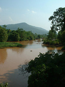
, the Nan River
and several of its tributaries, waterfalls, swamps, forests, grasslands, caves, a reservoir and an extensive network of canals. Populated areas of the province are largely cleared of natural vegetation and adapted for farming. The land within the province is situated in the Greater Nan Basin, which is part of the Chao Phraya Watershed. The province includes land within both of the Greater Nan Basin's sub-basins, i.e. the Nan Basin and Yom Basin. The provincial capital of Phitsanulok is sometimes called Song Kwae, the city of two rivers, an ancient name dating to a time centuries ago when the Nan
and Khwae Noi
rivers met near the city. These two rivers of the Phitsanulok Province are still of major significance to the residents of the region.
run through the province, and provide the source of several of the rivers and streams flowing through the region.
.
.
 The principal rivers that flow through the province belong to the Nan River System
. The following tree indicates the positions of the province's rivers in the Nan tributary tree:
. Kaeng Wang Nam Yen Rapids lie within Thung Salaeng Luang National Park
.
, which connect the farms to the Nan River
and its tributaries.
Phitsanulok Province
Phitsanulok is a provinces of Thailand, located in the north. Neighboring provinces are Loei, Phetchabun, Phichit, Kamphaeng Phet, Sukhothai, Uttaradit. In the north-east it also has a short border with Xaignabouli of Laos....
of Thailand
Thailand
Thailand , officially the Kingdom of Thailand , formerly known as Siam , is a country located at the centre of the Indochina peninsula and Southeast Asia. It is bordered to the north by Burma and Laos, to the east by Laos and Cambodia, to the south by the Gulf of Thailand and Malaysia, and to the...
include the Phetchabun Mountains
Phetchabun Mountains
The Phetchabun mountains are a mountain range in Thailand.-Geography:It extends in a roughly north-south direction, and separates the broad Chao Phraya river valley of central Thailand from the Khorat Plateau of northeast Thailand...
, the Nan River
Nan River
The Nan River is a river in Thailand. It is one of the most important tributaries of the Chao Phraya River.-Geography:The Nan River originates in Nan Province. The provinces along the river after Nan Province are Uttaradit, Phitsanulok and Phichit. The Yom River joins the Nan River at Chum Saeng...
and several of its tributaries, waterfalls, swamps, forests, grasslands, caves, a reservoir and an extensive network of canals. Populated areas of the province are largely cleared of natural vegetation and adapted for farming. The land within the province is situated in the Greater Nan Basin, which is part of the Chao Phraya Watershed. The province includes land within both of the Greater Nan Basin's sub-basins, i.e. the Nan Basin and Yom Basin. The provincial capital of Phitsanulok is sometimes called Song Kwae, the city of two rivers, an ancient name dating to a time centuries ago when the Nan
Nan River
The Nan River is a river in Thailand. It is one of the most important tributaries of the Chao Phraya River.-Geography:The Nan River originates in Nan Province. The provinces along the river after Nan Province are Uttaradit, Phitsanulok and Phichit. The Yom River joins the Nan River at Chum Saeng...
and Khwae Noi
Khwae Noi River, Phitsanulok
The Khwae Noi River is a river in northern Thailand. It shares the same name as another river in Thailand, the popular tourist attraction also known as "The River Kwai." These are two distinct bodies of water.-Etymology:...
rivers met near the city. These two rivers of the Phitsanulok Province are still of major significance to the residents of the region.
Mountains
The Phetchabun MountainsPhetchabun Mountains
The Phetchabun mountains are a mountain range in Thailand.-Geography:It extends in a roughly north-south direction, and separates the broad Chao Phraya river valley of central Thailand from the Khorat Plateau of northeast Thailand...
run through the province, and provide the source of several of the rivers and streams flowing through the region.
Forest
Most of Phitsanulok's forested areas are in the east of the province within Phitsanulok's national parks.Grasslands
There are several natural meadows or thung preserved in the province's Thung Salaeng Luang National ParkThung Salaeng Luang National Park
Thung Salaeng Luang National Park is a national park located in the Phitsanulok and Phetchabun Provinces of Thailand. It encompasses substantial portions of Amphoe Wang Thong and Amphoe Lom Sak.-Topography:...
.
Lands Adapted for Agricultural Use
The majority of inhabited lands in Phitsanulok (i.e., outside the National Parks) have been largely cleared of their natural vegetation and adapted for agricultural use, primarily rice farming. As a result, several of the indigenous species of plant life in the region have become endangeredEndangered species
An endangered species is a population of organisms which is at risk of becoming extinct because it is either few in numbers, or threatened by changing environmental or predation parameters...
.
Major Rivers
Nan River
The Nan River is a river in Thailand. It is one of the most important tributaries of the Chao Phraya River.-Geography:The Nan River originates in Nan Province. The provinces along the river after Nan Province are Uttaradit, Phitsanulok and Phichit. The Yom River joins the Nan River at Chum Saeng...
. The following tree indicates the positions of the province's rivers in the Nan tributary tree:
- Nan RiverNan RiverThe Nan River is a river in Thailand. It is one of the most important tributaries of the Chao Phraya River.-Geography:The Nan River originates in Nan Province. The provinces along the river after Nan Province are Uttaradit, Phitsanulok and Phichit. The Yom River joins the Nan River at Chum Saeng...
- Yom RiverYom RiverThe Yom River is the dime main tributary of the Nan River . The Yom originates in Pong district, Phayao Province, Thailand...
- Wat Ta Yom RiverWat Ta Yom River-Geography:This river of many names originates in the mountains of the Noen Maprang District of Phitsanulok Province where it is referred to as the Chomphu River ,...
- Tha Muen Ram RiverWat Ta Yom River-Geography:This river of many names originates in the mountains of the Noen Maprang District of Phitsanulok Province where it is referred to as the Chomphu River ,...
- Chomphu RiverWat Ta Yom River-Geography:This river of many names originates in the mountains of the Noen Maprang District of Phitsanulok Province where it is referred to as the Chomphu River ,...
- Chomphu River
- Tha Muen Ram River
- Wang Thong RiverWang Thong RiverThe Wang Thong River is a river in Thailand. Its source lies in the Phetchabun Mountains in the Khao Kho District, Thailand.It flows through Thung Salaeng Luang National Park and forms Namtok Sri Dit and Namtok Kaeng Sopha in the Wang Thong District of Phitsanulok Province, and finally flows...
- Khwae Noi RiverKhwae Noi River, PhitsanulokThe Khwae Noi River is a river in northern Thailand. It shares the same name as another river in Thailand, the popular tourist attraction also known as "The River Kwai." These are two distinct bodies of water.-Etymology:...
- Yom River
Streams
The minor rivers and streams which flow through Phitsanulok Province include the Fia, Kaem, Kap, Pak, Kleung, Bang Kaeo, Grung Grak, Ban Mung, and Tarai Yoi.Waterfalls
At least 9 waterfalls or namtok lie within the borders of the province:- Kaeng Song WaterfallNamtok Kaeng SongNamtok Kaeng Song is a waterfall and tourist attraction in the Wang Thong district of Phitsanulok Province in Thailand. This waterfall is situated on the Wang Thong River off Lomsak Road at kilometer 45. The falls have small pavilions to accommodate tourists, and concessions are sold on the...
- Kaeng Sopha WaterfallNamtok Kaeng SophaNamtok Kaeng Sopha is a waterfall and tourist attraction in Wang Thong district of Phitsanulok Province in Thailand. Situated in Thung Salaeng Luang National Park on the Wang Thong River off of Lomsak Road , between kilometers 71 and 72, it is the largest waterfall in Phitsanulok...
- Na Hin Waterfall
- Najan Waterfall
- Pakrong Waterfall (a.k.a. Chat Trakan Waterfall)
- Pha Ku Ka Waterfall
- Poi Waterfall
- Sri Dit WaterfallNamtok Sri DitNamtok Sri Dit is a waterfall and tourist attraction in Thailand. This waterfall is situated on the Wang Thong River and it runs throughout the year. At the falls, there is a rice mortar using power generated from the waterfall, built by the Communist Party of Thailand....
- Wang Nok Aen Waterfall
Rapids
Most rapids within the province are along the Wang Thong RiverWang Thong River
The Wang Thong River is a river in Thailand. Its source lies in the Phetchabun Mountains in the Khao Kho District, Thailand.It flows through Thung Salaeng Luang National Park and forms Namtok Sri Dit and Namtok Kaeng Sopha in the Wang Thong District of Phitsanulok Province, and finally flows...
. Kaeng Wang Nam Yen Rapids lie within Thung Salaeng Luang National Park
Thung Salaeng Luang National Park
Thung Salaeng Luang National Park is a national park located in the Phitsanulok and Phetchabun Provinces of Thailand. It encompasses substantial portions of Amphoe Wang Thong and Amphoe Lom Sak.-Topography:...
.
Canals
The farming industry of Phitsanulok is supported by an extensive network of irrigation canals called khlongKhlong
A khlong is the general name for a canal in the central plain of Thailand. These canals are spawned by the Chao Phraya, the Tha Chin, the Mae Klong Rivers and their tributaries...
, which connect the farms to the Nan River
Nan River
The Nan River is a river in Thailand. It is one of the most important tributaries of the Chao Phraya River.-Geography:The Nan River originates in Nan Province. The provinces along the river after Nan Province are Uttaradit, Phitsanulok and Phichit. The Yom River joins the Nan River at Chum Saeng...
and its tributaries.
Swamps
There are a number of swamps or bueng in Phitsanulok province. The most significant of these swamps are as follows:- Bueng Thakreng (Thai: บึงตะเคร็ง)
- Bueng Laman (Thai: บึงละมาน)
- Bueng Kee Raeng (Thai: บึงขี้แร้ง)
- Bueng Rachanok