
Toongabbie, New South Wales
Encyclopedia
Toongabbie is a suburb
of Sydney
, in the state of New South Wales
, Australia
. Toongabbie is located 30 kilometres west of the Sydney central business district
and is part of the Greater Western Sydney
region. Toongabbie is split between the local government areas of the City of Parramatta
, the City of Blacktown
and the City of Holroyd
.
; to the east is Old Toongabbie
; to the south-east, the next suburb (and railway station) is Pendle Hill
; to the south is Girraween
; to the south-west is Prospect
; and to the west the next suburb (and railway station) is Seven Hills
.
Arthur Phillip
asked the local Aborigines what they called the place.
 Toongabbie is noted for being the third mainland settlement (after Sydney and Parramatta) set up after the British
occupation of Australia began in 1788, although the site of the settlement is actually in the separate suburb of Old Toongabbie
.
Governor Phillip established a government farm and convict station on 640 acres (259 ha) in 1791 to grow food for the colony. It was supplement to the farms already established at Rose Hill. By December 1791 there were 500 men working at clearing the land. After eleven years, the government farm was closed and the land was given as grants to settlers and convicts who had done their time.
In 1860, the railway was extended to Blacktown but it took 20 years before any arrangements were made for trains to stop at Toongabbie. The first school in Toongabbie - Toongabbie Public School, opened on the 3rd of May 1886. By April 1911, the school closed due to low enrolments. The school reopened February the next year and has stayed open ever since.
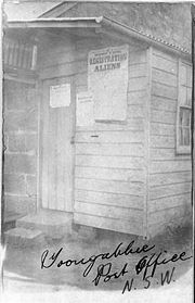
The first post office in the area was opened after many years of campaigning by local residents in 1887 in a private house on Old Windsor Road and this arrangement continued until the 1960s. The first post master was a Mr Birks and he was paid 25 pounds a year to manage the office and bring the mail bag over from Seven Hills on horseback each day. By 1922 the number of residents and businesses had grown sufficiently to support a second office in a weatherboard cottage in Wentworth Avenue, known as Toongabbie West. A purpose built office was opened in the main shopping area in Portico Parade in 1960 becoming Toongabbie Post Office whilst the old Toongabbie Post Office was renamed Old Toongabbie.
The Emu and Prospect Gravel and Road Metal Company Limited opened a private railway line from Toongabbie to Prospect Quarry on 7 April 1902. Following the inability of the Government railway to supply rail wagons, trains stopped running on the line in 1945, however the rails remained in situ until the early 1960s.
In 1908, what was probably the second scout group formed in Australia, 1st Toongabbie Scout Group was organised by Errol Knox (later knighted for his services to journalism). The first scout hall was a barn on his parents' property, "Montargis" in Binalong Road. Later, in 1934, the Group moved to its present location in Bungaree Road on donated land which had also once been part of the Knox landholdings.
The first bank branch in Toongabbie, The Commonwealth Bank, opened in 1957 although bank agencies had operated in the area.
Toongabbie was connected to electricity in the mid-1920s and to town gas and mains sewerage in the mid-1960s. The biggest increase in population occurred after World War II. A sizable area west of the shopping centre, which had previously been farmland and orchards, was subdivided into a housing development called "The Old Roman Estate"; several streets in the area have Roman names, including Marcia St, Lavinia St, Portia St, Lucretia Rd and Portico Parade.
, which includes the sites of the original colonial settlement. In the 1990s this area was reduced, with the part immediately north of Wentworthville, which is also known unofficially as the locality of Constitution Hill, being reclassified as Wentworthville. In 2006, Constitution Hill officially returned, but only as a small area between Bogalara Road and the Cumberland Highway.
in the late 1960s. Originally this was simply the name of a large housing development in the area, but a large section of what was once Old Toongabbie was officially renamed Winston Hills in the 1970s, a trend that has been echoed in many other areas of the western suburbs.
, a shopping centre with a Woolworths supermarket and over 40 specialty shops.
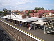 Toongabbie railway station is on the Western line of the CityRail
network. The original unstaffed station opened on 26 April 1880 and was upgraded over the years with additional platforms and loading facilities. In the late 1880s the first rail official was appointed to manage the station, a Miss Amy Arnold. The current station was opened in 1946 and the line was electrified in 1955. The overhead road bridge was opened in 1947 (before that there was a level crossing where the western end of the station platforms are now).
To the west, the next station on the line is Seven Hills and to the east Pendle Hill.
Toongabbie is also served by private buses with connections to Blacktown via Blacktown Road
, Seven Hills via the Prospect Highway, Sydney
, and both Parramatta
and Westmead
via the Great Western Highway
.
In addition to this, Toongabbie is also served by the T-Way bus service.
; the area west of Greystanes or Girraween Creek and south-west of the railway is in the City of Blacktown
; and the remaining part south of the railway is in the City of Holroyd
.
Suburb
The word suburb mostly refers to a residential area, either existing as part of a city or as a separate residential community within commuting distance of a city . Some suburbs have a degree of administrative autonomy, and most have lower population density than inner city neighborhoods...
of Sydney
Sydney
Sydney is the most populous city in Australia and the state capital of New South Wales. Sydney is located on Australia's south-east coast of the Tasman Sea. As of June 2010, the greater metropolitan area had an approximate population of 4.6 million people...
, in the state of New South Wales
New South Wales
New South Wales is a state of :Australia, located in the east of the country. It is bordered by Queensland, Victoria and South Australia to the north, south and west respectively. To the east, the state is bordered by the Tasman Sea, which forms part of the Pacific Ocean. New South Wales...
, Australia
Australia
Australia , officially the Commonwealth of Australia, is a country in the Southern Hemisphere comprising the mainland of the Australian continent, the island of Tasmania, and numerous smaller islands in the Indian and Pacific Oceans. It is the world's sixth-largest country by total area...
. Toongabbie is located 30 kilometres west of the Sydney central business district
Sydney central business district
The Sydney central business district is the main commercial centre of Sydney, New South Wales, Australia. It extends southwards for about 3 kilometres from Sydney Cove, the point of first European settlement. Its north–south axis runs from Circular Quay in the north to Central railway station in...
and is part of the Greater Western Sydney
Greater Western Sydney
Greater Western Sydney is a term used to describe the western region of the metropolitan area of Sydney, Australia. The University of Western Sydney defines Greater Western Sydney as comprising 14 local government areas...
region. Toongabbie is split between the local government areas of the City of Parramatta
City of Parramatta
The City of Parramatta is a Local Government Area in western Sydney, in the state of New South Wales, Australia.Initially in 1861 it was formed as Municipality of Parramatta...
, the City of Blacktown
City of Blacktown
The City of Blacktown is a Local Government Area in the heart of Western Sydney, situated on the Cumberland Plain, approximately 35 km from Sydney CBD. It is bounded by the Local Government Areas of Penrith, Parramatta, Fairfield, Holroyd, Hawkesbury and The Hills Shire. It occupies an area...
and the City of Holroyd
City of Holroyd
Holroyd is a Local Government Area and suburb of Sydney, New South Wales, Australia, located in the Western Sydney region. Originally known as the Municipality of Prospect and Sherwood it was incorporated in February 1872, in 1927 it was renamed the Municipality of Holroyd after Arthur Holroyd,...
.
Geography
To the north across Old Windsor Road the next suburb is Winston HillsWinston Hills, New South Wales
Winston Hills is a suburb of Sydney, in the state of New South Wales, Australia. Winston Hills is located 28 kilometres west of the Sydney central business district in the local government area of the City of Parramatta and the Greater Western Sydney region....
; to the east is Old Toongabbie
Old Toongabbie, New South Wales
Old Toongabbie is a suburb of Sydney, in the state of New South Wales, Australia. Old Toongabbie is located 29 kilometres west of the Sydney central business district in the local government area of the City of Parramatta and is part of the Greater Western Sydney region.- History:Toongabbie is...
; to the south-east, the next suburb (and railway station) is Pendle Hill
Pendle Hill, New South Wales
Pendle Hill is a suburb of Sydney, in the state of New South Wales, Australia. Pendle Hill is located 30 kilometres west of the Sydney central business district, in the local government area of the City of Holroyd and is part of the Greater Western Sydney region.-History:George Bond , an American...
; to the south is Girraween
Girraween, New South Wales
Girraween is a suburb of Sydney, in the state of New South Wales, Australia. Girraween is located 30 km west of the Sydney central business district, in the local government area of the City of Holroyd and is part of the Greater Western Sydney region....
; to the south-west is Prospect
Prospect, New South Wales
Prospect is a suburb of Sydney, in the state of New South Wales, Australia. Prospect is located 32 kilometres west of the Sydney central business district in the local government area of the City of Blacktown and is part of the Greater Western Sydney region....
; and to the west the next suburb (and railway station) is Seven Hills
Seven Hills, New South Wales
Seven Hills is a suburb of Sydney, in the state of New South Wales, Australia. Seven Hills is located 34 kilometres west of the Sydney central business district in the local government area of the City of Blacktown. Seven Hills is part of the Greater Western Sydney region...
.
History
Toongabbie is derived from an Aboriginal word, reported as meaning place by the water or the meeting of the waters. It was named in June 1792 after GovernorGovernor
A governor is a governing official, usually the executive of a non-sovereign level of government, ranking under the head of state...
Arthur Phillip
Arthur Phillip
Admiral Arthur Phillip RN was a British admiral and colonial administrator. Phillip was appointed Governor of New South Wales, the first European colony on the Australian continent, and was the founder of the settlement which is now the city of Sydney.-Early life and naval career:Arthur Phillip...
asked the local Aborigines what they called the place.
European settlement
United Kingdom
The United Kingdom of Great Britain and Northern IrelandIn the United Kingdom and Dependencies, other languages have been officially recognised as legitimate autochthonous languages under the European Charter for Regional or Minority Languages...
occupation of Australia began in 1788, although the site of the settlement is actually in the separate suburb of Old Toongabbie
Old Toongabbie, New South Wales
Old Toongabbie is a suburb of Sydney, in the state of New South Wales, Australia. Old Toongabbie is located 29 kilometres west of the Sydney central business district in the local government area of the City of Parramatta and is part of the Greater Western Sydney region.- History:Toongabbie is...
.
Governor Phillip established a government farm and convict station on 640 acres (259 ha) in 1791 to grow food for the colony. It was supplement to the farms already established at Rose Hill. By December 1791 there were 500 men working at clearing the land. After eleven years, the government farm was closed and the land was given as grants to settlers and convicts who had done their time.
In 1860, the railway was extended to Blacktown but it took 20 years before any arrangements were made for trains to stop at Toongabbie. The first school in Toongabbie - Toongabbie Public School, opened on the 3rd of May 1886. By April 1911, the school closed due to low enrolments. The school reopened February the next year and has stayed open ever since.
The first post office in the area was opened after many years of campaigning by local residents in 1887 in a private house on Old Windsor Road and this arrangement continued until the 1960s. The first post master was a Mr Birks and he was paid 25 pounds a year to manage the office and bring the mail bag over from Seven Hills on horseback each day. By 1922 the number of residents and businesses had grown sufficiently to support a second office in a weatherboard cottage in Wentworth Avenue, known as Toongabbie West. A purpose built office was opened in the main shopping area in Portico Parade in 1960 becoming Toongabbie Post Office whilst the old Toongabbie Post Office was renamed Old Toongabbie.
The Emu and Prospect Gravel and Road Metal Company Limited opened a private railway line from Toongabbie to Prospect Quarry on 7 April 1902. Following the inability of the Government railway to supply rail wagons, trains stopped running on the line in 1945, however the rails remained in situ until the early 1960s.
In 1908, what was probably the second scout group formed in Australia, 1st Toongabbie Scout Group was organised by Errol Knox (later knighted for his services to journalism). The first scout hall was a barn on his parents' property, "Montargis" in Binalong Road. Later, in 1934, the Group moved to its present location in Bungaree Road on donated land which had also once been part of the Knox landholdings.
The first bank branch in Toongabbie, The Commonwealth Bank, opened in 1957 although bank agencies had operated in the area.
Toongabbie was connected to electricity in the mid-1920s and to town gas and mains sewerage in the mid-1960s. The biggest increase in population occurred after World War II. A sizable area west of the shopping centre, which had previously been farmland and orchards, was subdivided into a housing development called "The Old Roman Estate"; several streets in the area have Roman names, including Marcia St, Lavinia St, Portia St, Lucretia Rd and Portico Parade.
Old Toongabbie
To the east of Binalong Road is the small suburb known as Old ToongabbieOld Toongabbie, New South Wales
Old Toongabbie is a suburb of Sydney, in the state of New South Wales, Australia. Old Toongabbie is located 29 kilometres west of the Sydney central business district in the local government area of the City of Parramatta and is part of the Greater Western Sydney region.- History:Toongabbie is...
, which includes the sites of the original colonial settlement. In the 1990s this area was reduced, with the part immediately north of Wentworthville, which is also known unofficially as the locality of Constitution Hill, being reclassified as Wentworthville. In 2006, Constitution Hill officially returned, but only as a small area between Bogalara Road and the Cumberland Highway.
Winston Hills
The more northerly parts, north of Toongabbie Creek, became known as Winston HillsWinston Hills, New South Wales
Winston Hills is a suburb of Sydney, in the state of New South Wales, Australia. Winston Hills is located 28 kilometres west of the Sydney central business district in the local government area of the City of Parramatta and the Greater Western Sydney region....
in the late 1960s. Originally this was simply the name of a large housing development in the area, but a large section of what was once Old Toongabbie was officially renamed Winston Hills in the 1970s, a trend that has been echoed in many other areas of the western suburbs.
Commercial area
Toongabbie's shopping precinct is located in Aurelia Street to the south of the railway line next to the station. The shopping precinct for many years included a small suburban cinema, the "Rocket", located opposite the railway line, next to the overhead road bridge. It operated from the late 1950s until the early 1970s, when it was demolished and replaced by a row of shops. A small shopping centre and supermarket, the Piccadilly Centre, was built in the 1960s in the area bounded by the Toongabbie Hotel and the Catholic Church. This operated until 2004 when the Piccadilly shopping centre and surrounding properties were purchased by a developer to eventually build Portico PlazaPortico Plaza
Portico Plaza, a shopping centre located in Toongabbie, Australia, when fully leased, will host over 40 specialty shops. At around 8,000 square metres, Portico Plaza is larger than a typical Australian supermarket based neighbourhood shopping centre with a higher proportion of retail and non-retail...
, a shopping centre with a Woolworths supermarket and over 40 specialty shops.
Transport
CityRail
CityRail is an operating brand of RailCorp, a corporation owned by the state government of New South Wales, Australia. It is responsible for providing commuter rail services, and some coach services, in and around Sydney, Newcastle and Wollongong, the three largest cities of New South Wales. It is...
network. The original unstaffed station opened on 26 April 1880 and was upgraded over the years with additional platforms and loading facilities. In the late 1880s the first rail official was appointed to manage the station, a Miss Amy Arnold. The current station was opened in 1946 and the line was electrified in 1955. The overhead road bridge was opened in 1947 (before that there was a level crossing where the western end of the station platforms are now).
To the west, the next station on the line is Seven Hills and to the east Pendle Hill.
Toongabbie is also served by private buses with connections to Blacktown via Blacktown Road
Blacktown Road, Sydney
Blacktown Road is a secondary road which links the City of Blacktown to the M4 motorway in Sydney, Australia adjacent to the Great Western Highway....
, Seven Hills via the Prospect Highway, Sydney
Prospect Highway, Sydney
The Prospect Highway is now a secondary link road in the Sydney, Australia road network. It provides a free alternative link from the M4 Western to the M2 Hills Motorways, the Westlink M7 being a toll road....
, and both Parramatta
Parramatta, New South Wales
Parramatta is a suburb of Sydney, in the state of New South Wales, Australia. It is located in Greater Western Sydney west of the Sydney central business district on the banks of the Parramatta River. Parramatta is the administrative seat of the Local Government Area of the City of Parramatta...
and Westmead
Westmead, New South Wales
Westmead is a suburb of Sydney, in the state of New South Wales, Australia. Westmead is located 26 kilometres west of the Sydney central business district, in the local government area of the City of Parramatta and is part of the Greater Western Sydney region....
via the Great Western Highway
Great Western Highway
The Great Western Highway is a highway in New South Wales, Australia. It runs 210 km from Sydney to Bathurst.Starting as Broadway at the intersection of City Road near the fringe of the Sydney CBD, and becoming Parramatta Road to Parramatta itself, the Great Western Highway heads due west from...
.
In addition to this, Toongabbie is also served by the T-Way bus service.
Landmarks
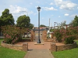
Although Toongabbie is relatively densely settled, in recent years programmes of bushland regeneration, and pollution control in local waterways have improved the few and small pockets of vegetation in the suburb. The main waterway is Greystanes or Girraween Creek which flows the length of the suburb from Fox Hills Golf Course in the south to join Blacktown Creek in the north. A one kilometre section of Greystanes Creek has been channelised as part of a flood-mitigation project.Notable residents
- Bruce BeresfordBruce BeresfordBruce Beresford is an Australian film director who has made more than 30 feature films over a 40-year career.-Early life:...
- film director, writer, and producer spent his childhood here - John LarkinJohn LarkinJohn Larkin may refer to:*John Larkin , Belfast-born legal scholar*John Paul Larkin , American jazz musician known as Scatman John...
- author, grew up in Toongabbie and detailed this in his childhood memoir The Pacifist's Guide to Self-Flagellation - Karl FiligaKarl FiligaKarlos Filiga is a rugby league player for the Parramatta Eels in the National Rugby League competition. Filiga primarily plays at centre or in second row...
- Former NRL player for the Cronulla Sharks - Matthew Lyle Smith - Australian musical solo artist now based in Melbourne, lived in Toongabbie from birth in 1970 before leaving in 2000.
- Christopher Robert Smith - Reconciliation activist, Guru/Mentor to 1000s
Politics
Toongabbie is split between three Local Government Areas - the area north-east of the Western Railway line is in the City of ParramattaCity of Parramatta
The City of Parramatta is a Local Government Area in western Sydney, in the state of New South Wales, Australia.Initially in 1861 it was formed as Municipality of Parramatta...
; the area west of Greystanes or Girraween Creek and south-west of the railway is in the City of Blacktown
City of Blacktown
The City of Blacktown is a Local Government Area in the heart of Western Sydney, situated on the Cumberland Plain, approximately 35 km from Sydney CBD. It is bounded by the Local Government Areas of Penrith, Parramatta, Fairfield, Holroyd, Hawkesbury and The Hills Shire. It occupies an area...
; and the remaining part south of the railway is in the City of Holroyd
City of Holroyd
Holroyd is a Local Government Area and suburb of Sydney, New South Wales, Australia, located in the Western Sydney region. Originally known as the Municipality of Prospect and Sherwood it was incorporated in February 1872, in 1927 it was renamed the Municipality of Holroyd after Arthur Holroyd,...
.