

Tokyo Bay Aqua-Line
Encyclopedia
Bridge-tunnel
A fixed link, fixed crossing, or bridge-tunnel is a persistent, unbroken road or rail connection across water that uses some combination of bridges, tunnels, and causeways and does not involve intermittent connections such as drawbridges or ferries.The Confederation Bridge was commonly referred to...
combination across Tokyo Bay
Tokyo Bay
is a bay in the southern Kantō region of Japan. Its old name was .-Geography:Tokyo Bay is surrounded by the Bōsō Peninsula to the east and the Miura Peninsula to the west. In a narrow sense, Tokyo Bay is the area north of the straight line formed by the on the Miura Peninsula on one end and on...
in Japan
Japan
Japan is an island nation in East Asia. Located in the Pacific Ocean, it lies to the east of the Sea of Japan, China, North Korea, South Korea and Russia, stretching from the Sea of Okhotsk in the north to the East China Sea and Taiwan in the south...
.
It connects the city of Kawasaki
Kawasaki, Kanagawa
is a city located in Kanagawa Prefecture, Japan, between Tokyo and Yokohama. It is the 9th most populated city in Japan and one of the main cities forming the Greater Tokyo Area and Keihin Industrial Area....
in Kanagawa Prefecture
Kanagawa Prefecture
is a prefecture located in the southern Kantō region of Japan. The capital is Yokohama. Kanagawa is part of the Greater Tokyo Area.-History:The prefecture has some archaeological sites going back to the Jōmon period...
with the city of Kisarazu
Kisarazu, Chiba
is a city located in Chiba, Japan. As of September 2010, Kisarazu has an estimated population of 126,906 and a density of 915 persons per km². The total area was 138.73 km²....
in Chiba Prefecture
Chiba Prefecture
is a prefecture of Japan located in the Kantō region and the Greater Tokyo Area. Its capital is Chiba City.- History :Chiba Prefecture was established on June 15, 1873 with the merger of Kisarazu Prefecture and Inba Prefecture...
, and forms part of National Route 409
Route 409 (Japan)
National Route 409 is a national highway of Japan connecting Takatsu-ku, Kawasaki and Narita, Chiba in Japan, with a total length of 119.3 km ....
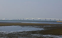
. With an overall length of 14 km, it includes a 4.4 km bridge and 9.6 km tunnel underneath the bay—the fourth-longest underwater tunnel in the world.
Overview
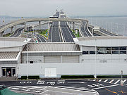
Artificial island
An artificial island or man-made island is an island or archipelago that has been constructed by people rather than formed by natural means...
called with a rest area consisting of restaurants, shops and amusement facilities. Air is supplied to the tunnel by a distinctive tower in the middle of the tunnel, called the Kaze no Tō (風の塔, "the tower of wind"), which uses the bay's almost-constant winds as a power source.
The road opened on December 18, 1997 after 31 years of construction at a cost of 1.44 trillion yen (11.2 billion USD at the time of opening).
The Tokyo Bay Aqua-Line reduced the drive between Chiba and Kanagawa, two important industrial regions, from 90 to 15 minutes, and also contributed to cut the travel time to the sea leisure area in the southern part of the Bōsō Peninsula
Boso Peninsula
thumb|Locationthumb|Landsat image with high-resolution data from Space Shuttle is a peninsula in Chiba prefecture on Honshū, the largest island of Japan. It forms the eastern edge of Tokyo Bay, separating it from the Pacific Ocean....
from Tokyo and Kanagawa. Before the tunnel opened, one had to drive a roundabout 100 km along the shores of Tokyo Bay
Tokyo Bay
is a bay in the southern Kantō region of Japan. Its old name was .-Geography:Tokyo Bay is surrounded by the Bōsō Peninsula to the east and the Miura Peninsula to the west. In a narrow sense, Tokyo Bay is the area north of the straight line formed by the on the Miura Peninsula on one end and on...
and pass through downtown Tokyo.
One goal expressed during the planning of the Aqua-Line was to reduce the traffic through downtown Tokyo, but as the highway toll is quite high, the reduction in Tokyo traffic has not been as great as expected.
Many highway bus services now use the Tokyo Bay Aqua-Line, including lines from Tokyo Station
Tokyo Station
is a train station located in the Marunouchi business district of Chiyoda, Tokyo, Japan, near the Imperial Palace grounds and the Ginza commercial district....
, Yokohama Station
Yokohama Station
is a main interchange station located in Nishi-ku, Yokohama, Japan. It is the busiest station in Kanagawa Prefecture and the 5th busiest in Japan as of 2004, serving 2.05 million passengers daily.-Lines:Yokohama Station is served by the following lines:...
and Haneda Airport to Kisarazu, Kimitsu
Kimitsu, Chiba
is a city located in Chiba, Japan. As of September 2010, the city had an estimated population of 88,661 and a population density of 278 persons per km². The total area was 318.83 km².-Geography:...
, Kamogawa
Kamogawa, Chiba
is a city located in Chiba Prefecture, Japan.As of 2010, the city had an estimated population of 35,257 and a population density of 184 persons per km². The total area was 191.30 km²...
, Katsuura
Katsuura, Chiba
is a city located in southern part of Chiba Prefecture, Japan. Katsuura city is famous for Katsuura Fishing Port, which features one of the top three largest morning markets in Japan. As of February 2010, the city has an estimated population of 20,570 and the density of 218 persons per km²...
and Tateyama
Tateyama, Chiba
is a city located in Chiba Prefecture, Japan. As of September 2010, the city had an estimated population of 49,315 and the population density of 447 persons per km². The total area was 110.21 km²...
.
Tolls and U-turns
The cash toll for a single trip on the Aqua-Line is ¥3000 (about $32.86USD) for ordinary-size cars (¥2400 for kei carKei car
Kei cars, K-cars, or , are a Japanese category of small vehicles, including passenger cars, vans, and pickup trucks. They are designed to comply with Japanese government tax and insurance regulations, and in most rural areas are exempted from the requirement to certify that adequate parking is...
s); however, using the ETC
ETC
The abbreviation etc or ETC may stand for:* et cetera, a Latin expression meaning "and other things" or "and so on"In economics and finance:* Early Termination Chargers, a type of penalty chargers if break the contract...
(electronic toll collection) system, the fare is ¥2320 (¥1860 for kei cars). The ETC toll is reduced to ¥1000 on Saturdays, Sundays and Holidays. In general, tolls for usage of the Aqua-Line in either direction are collected at the mainline toll plaza on the Kisarazu end.
NOTE: From August 1, 2009 to March 31, 2011, the regular ETC toll will be reduced to ¥800 for ordinary-size cars (¥640 for kei cars) for a trial period aimed at increasing usage.