Togwotee Pass
Encyclopedia
Togwotee Pass (el. 9658 ft/2944 m) is a mountain pass
located on the continental divide
in the Absaroka Mountains of the United States
, between the towns of Dubois
and Moran Junction, Wyoming in the Jackson Hole
valley.
U.S. Highway 287 and U.S. Highway 26 cross the pass, which is located approximately 25 miles (40 km) east of Moran Junction. The pass provides the most direct access to Grand Teton National Park
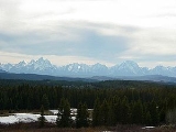
from eastern Wyoming. Sweeping vistas of the Teton Range
are visible from the western slopes of the pass.
The pass is located in the Bridger-Teton National Forest
and adjacent to Shoshone National Forest
. The pass receives heavy winter snowfall and is a top destination for snowmobiling and cross-country skiing
. Snowfall at the pass often exceeds 25 feet (760 cm) (reports of over 50 feet (15 m) of snow are also known) in any given winter and the road can be shut down for days at a time during blizzard
s. The Continental Divide Snowmobile Trail passes through the immediate area.
The pass is named for Togwotee, a subchief under Chief Washakie of the Sheepeater tribe, a branch of the Shoshone
s. Togwotee led a U.S. government exploratory expedition over this pass in 1873.
A ski run (mainly a traverse) at the Jackson Hole ski resort is also named Togwotee Pass. http://www.jacksonhole.com/info/mtn.trailinfo.asp
Mountain pass
A mountain pass is a route through a mountain range or over a ridge. If following the lowest possible route, a pass is locally the highest point on that route...
located on the continental divide
Continental divide
A continental divide is a drainage divide on a continent such that the drainage basin on one side of the divide feeds into one ocean or sea, and the basin on the other side either feeds into a different ocean or sea, or else is endorheic, not connected to the open sea...
in the Absaroka Mountains of the United States
United States
The United States of America is a federal constitutional republic comprising fifty states and a federal district...
, between the towns of Dubois
Dubois, Wyoming
Dubois is a town in Fremont County, Wyoming. The population was 962 at the 2000 census, although it nearly doubles in the summer with many part-time residents.-Geography:...
and Moran Junction, Wyoming in the Jackson Hole
Jackson Hole
Jackson Hole, originally called Jackson's Hole, is a valley located in the U.S. state of Wyoming, near the western border with Idaho. The name "hole" derives from language used by early trappers or mountain men, who primarily entered the valley from the north and east and had to descend along...
valley.
U.S. Highway 287 and U.S. Highway 26 cross the pass, which is located approximately 25 miles (40 km) east of Moran Junction. The pass provides the most direct access to Grand Teton National Park
Grand Teton National Park
Grand Teton National Park is a United States National Park located in northwestern Wyoming, U.S. The Park consists of approximately and includes the major peaks of the long Teton Range as well as most of the northern sections of the valley known as Jackson Hole. Only south of Yellowstone...
from eastern Wyoming. Sweeping vistas of the Teton Range
Teton Range
The Teton Range is a mountain range of the Rocky Mountains in North America. A north-south range, it is on the Wyoming side of the state's border with Idaho, just south of Yellowstone National Park. Most of the range is in Grand Teton National Park....
are visible from the western slopes of the pass.
The pass is located in the Bridger-Teton National Forest
Bridger-Teton National Forest
Bridger-Teton National Forest is located in western Wyoming, United States. The forest consists of , making it the second largest National Forest outside of Alaska. The forest stretches from Yellowstone National Park, along the eastern boundary of Grand Teton National Park and from there rides...
and adjacent to Shoshone National Forest
Shoshone National Forest
Shoshone National Forest is the first federally protected National Forest in the United States and covers nearly 2.5 million acres in the state of Wyoming. Originally a part of the Yellowstone Timberland Reserve, the forest was created by an act of Congress and signed into law by U.S....
. The pass receives heavy winter snowfall and is a top destination for snowmobiling and cross-country skiing
Cross-country skiing
Cross-country skiing is a winter sport in which participants propel themselves across snow-covered terrain using skis and poles...
. Snowfall at the pass often exceeds 25 feet (760 cm) (reports of over 50 feet (15 m) of snow are also known) in any given winter and the road can be shut down for days at a time during blizzard
Blizzard
A blizzard is a severe snowstorm characterized by strong winds. By definition, the difference between blizzard and a snowstorm is the strength of the wind. To be a blizzard, a snow storm must have winds in excess of with blowing or drifting snow which reduces visibility to 400 meters or ¼ mile or...
s. The Continental Divide Snowmobile Trail passes through the immediate area.
The pass is named for Togwotee, a subchief under Chief Washakie of the Sheepeater tribe, a branch of the Shoshone
Shoshone
The Shoshone or Shoshoni are a Native American tribe in the United States with three large divisions: the Northern, the Western and the Eastern....
s. Togwotee led a U.S. government exploratory expedition over this pass in 1873.
A ski run (mainly a traverse) at the Jackson Hole ski resort is also named Togwotee Pass. http://www.jacksonhole.com/info/mtn.trailinfo.asp

